
Browse "Places"
-
Article
Colonial Building
The Colonial Building, in St John's, NL, was declared a provincial historical site by an act of the legislature of Newfoundland in 1974.
"https://d3d0lqu00lnqvz.cloudfront.net/media/media/7ef97226-7c00-45f3-a406-be37c48cf23c.jpg" // resources/views/front/categories/view.blade.php
https://d3d0lqu00lnqvz.cloudfront.net/media/media/7ef97226-7c00-45f3-a406-be37c48cf23c.jpg
-
Article
Columbia Icefield
The Columbia Icefield is a mass of ice covering a high plateau between Mount Columbia (3747 m), the highest point in Alberta, and Mount Athabasca (3491 m), located between Banff and Jasper national parks, along the BC-Alberta border.
"https://d3d0lqu00lnqvz.cloudfront.net/media/media/4f68d2f4-7717-496d-a427-bbafb71196fd.jpg" // resources/views/front/categories/view.blade.php
https://d3d0lqu00lnqvz.cloudfront.net/media/media/4f68d2f4-7717-496d-a427-bbafb71196fd.jpg
-
Article
Columbia Mountains
The Columbia Mountains are a block of mountains 608 km long and 256 km wide that dominate the landscape of southeastern British Columbia. The Monashee, Selkirk and Purcell mountains form parallel lines extending North-South from the United States to the Rocky Mountain Trench.
"https://d3d0lqu00lnqvz.cloudfront.net/media/media/9b6a1cce-c95d-4cf8-ab82-694169a097f7.jpg" // resources/views/front/categories/view.blade.php
https://d3d0lqu00lnqvz.cloudfront.net/media/media/9b6a1cce-c95d-4cf8-ab82-694169a097f7.jpg
-
Article
Columbia River
The Columbia River runs from the southeast corner of British Columbia through Washington and Oregon states to the Pacific Ocean.
"https://d3d0lqu00lnqvz.cloudfront.net/media/media/f6484519-d20a-4287-b03f-bbe3bc2519fd.png" // resources/views/front/categories/view.blade.php
https://d3d0lqu00lnqvz.cloudfront.net/media/media/f6484519-d20a-4287-b03f-bbe3bc2519fd.png
-
Article
Colwood
Colwood, BC, incorporated as a city in 1985, population 16 093 (2011c), 14 687 (2006c). The City of Colwood is part of Greater Victoria and located ten kilometres west of downtown VICTORIA. Colwood takes its name from the farm run by Captain Edward E.
"https://d3d0lqu00lnqvz.cloudfront.net/media/media/f9d724d8-4cdb-41f1-a12e-cbff359501cd.jpg" // resources/views/front/categories/view.blade.php
https://d3d0lqu00lnqvz.cloudfront.net/media/media/f9d724d8-4cdb-41f1-a12e-cbff359501cd.jpg
-
Article
Come by Chance
Come By Chance, Newfoundland and Labrador, incorporated as a town in 1969, population 208 (2021 census), 228 (2016 census). The town of Come by Chance is located at the head of Placentia Bay on the Isthmus of Avalon.
"https://d3d0lqu00lnqvz.cloudfront.net/media/media/29533281-0a15-48be-ab25-8c86277c7732.jpg" // resources/views/front/categories/view.blade.php
https://d3d0lqu00lnqvz.cloudfront.net/media/media/29533281-0a15-48be-ab25-8c86277c7732.jpg
-
Article
Commissariat House
Commissariat House is a provincial HISTORIC SITE (designated in1977) located in ST JOHN'S, NL, and is an excellent example of Georgian architecture. Constructed between 1818 and 1820, it was built to house the Commissariat
"https://d3d0lqu00lnqvz.cloudfront.net/media/media/60f97f93-5637-43c2-986f-dc001ec68466.jpg" // resources/views/front/categories/view.blade.php
https://d3d0lqu00lnqvz.cloudfront.net/media/media/60f97f93-5637-43c2-986f-dc001ec68466.jpg
-
Article
Comox
Comox, British Columbia, incorporated as a town in 1967, population 14,806 (2021 census), 14,028 (2016 census). The Town of Comox is located on the east coast of Vancouver Island, 223 km north of Victoria, overlooking Comox Harbour.
"https://d3d0lqu00lnqvz.cloudfront.net/Comox/Comox.jpg" // resources/views/front/categories/view.blade.php
https://d3d0lqu00lnqvz.cloudfront.net/Comox/Comox.jpg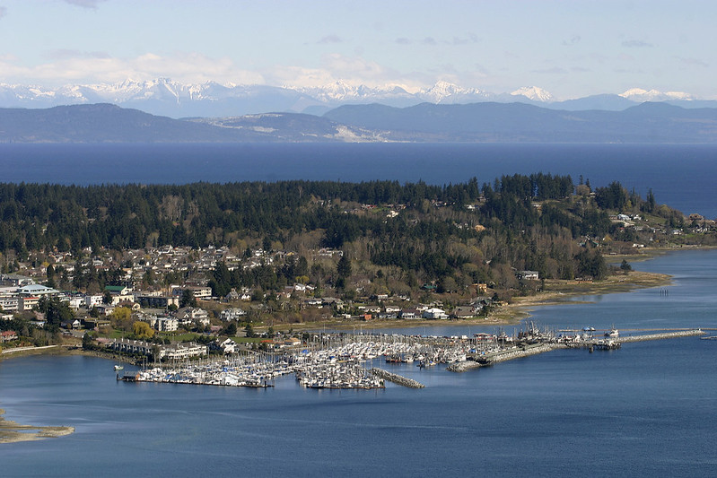
-
Article
Comox Valley Youth Music Centre
Comox Valley Youth Music Centre (formerly Courtenay Youth Music Camp).
"https://thecanadianencyclopedia.ca/images/tce_placeholder.jpg?v=e9dca980c9bdb3aa11e832e7ea94f5d9" // resources/views/front/categories/view.blade.php
https://thecanadianencyclopedia.ca/images/tce_placeholder.jpg?v=e9dca980c9bdb3aa11e832e7ea94f5d9
-
Article
Conception Bay
Conception Bay is one of the principal bays of Newfoundland, formed by 2 north-reaching arms of the Avalon Peninsula.
"https://d3d0lqu00lnqvz.cloudfront.net/media/media/10880883-dae5-469a-b120-3fae8e4d17c2.jpg" // resources/views/front/categories/view.blade.php
https://d3d0lqu00lnqvz.cloudfront.net/media/media/10880883-dae5-469a-b120-3fae8e4d17c2.jpg
-
Article
Conception Bay South
Conception Bay South, NL, incorporated as a town in 1973, population 24 848 (2011c), 21 966 (2006c). The town of Conception Bay South is located on the southeast shore of Conception Bay on the Avalon Peninsula.
"https://thecanadianencyclopedia.ca/images/tce_placeholder.jpg?v=e9dca980c9bdb3aa11e832e7ea94f5d9" // resources/views/front/categories/view.blade.php
https://thecanadianencyclopedia.ca/images/tce_placeholder.jpg?v=e9dca980c9bdb3aa11e832e7ea94f5d9
-
Article
Concert Halls and Opera Houses
Most 18th- and 19th-century structures have not survived fires and demolition. However, some travellers and residents left brief descriptions of these early buildings.
"https://d3d0lqu00lnqvz.cloudfront.net/media/media/166703c4-0f01-4a62-b6f8-055b0dea552a.jpg" // resources/views/front/categories/view.blade.php
https://d3d0lqu00lnqvz.cloudfront.net/media/media/166703c4-0f01-4a62-b6f8-055b0dea552a.jpg
-
Article
Concert Halls and Opera Houses
Concert halls and opera houses. Perhaps the oldest references to a venue for musical performance are the ones found in the Quebec Gazette of 29 Nov and 24 Dec 1764 which advertise dances to be held at the Concert Hall.
"https://thecanadianencyclopedia.ca/images/tce_placeholder.jpg?v=e9dca980c9bdb3aa11e832e7ea94f5d9" // resources/views/front/categories/view.blade.php
https://thecanadianencyclopedia.ca/images/tce_placeholder.jpg?v=e9dca980c9bdb3aa11e832e7ea94f5d9
-
Article
Condominium
Owners in a condominium project are responsible for all expenses relating to their own individual unit, but in addition the condominium owners must pay their share of the expenses relating to the common areas.
"https://d3d0lqu00lnqvz.cloudfront.net/media/media/0f0cb5c6-72a1-44ab-93be-c5bf3c959f89.jpg" // resources/views/front/categories/view.blade.php
https://d3d0lqu00lnqvz.cloudfront.net/media/media/0f0cb5c6-72a1-44ab-93be-c5bf3c959f89.jpg
-
Article
Confederation Bridge
The Confederation Bridge is the longest bridge in the world crossing ice-covered water. The toll bridge spans a 12.9 km stretch of the Northumberland Strait connecting Borden-Carleton, Prince Edward Island, to Cape Jourimain, New Brunswick. Although the bridge would provide a faster and more reliable link to the mainland, the decision to proceed sparked heated debate on the Island. The $840-million bridge opened on 31 May 1997.
"https://d3d0lqu00lnqvz.cloudfront.net/media/media/23f11b74-72ab-4917-9c7f-53a5eaa76eb1.jpg" // resources/views/front/categories/view.blade.php
https://d3d0lqu00lnqvz.cloudfront.net/media/media/23f11b74-72ab-4917-9c7f-53a5eaa76eb1.jpg