
Browse "Cities & Populated Places"
-
Article
100 Mile House
100 Mile House, British Columbia, incorporated as a district municipality in 1991, population 1,980 (2016 census), 1,886 (2011 census). The district of 100 Mile House is located in the South Cariboo region of south-central British Columbia on Highway 97. It is 456 km northeast of Vancouver.
"https://d3d0lqu00lnqvz.cloudfront.net/media/new_article_images/100MileHouse/100_mile_house_1928.jpg" // resources/views/front/categories/view.blade.php
https://d3d0lqu00lnqvz.cloudfront.net/media/new_article_images/100MileHouse/100_mile_house_1928.jpg
-
Article
Abbotsford
Abbotsford, British Columbia, incorporated as a city in 1995, population 153,524 (2021 census), 141,397 (2016 census). The amalgamation of the district municipalities of Matsqui and Abbotsford formed the city of Abbotsford. Abbotsford is located on the south bank of the Fraser River, 76 km east of Vancouver. The city is named after Harry Braithwaite Abbott, the general superintendent for the British Columbia division of the Canadian Pacific Railway. Abbotsford is BC's fifth most populous municipality.
"https://thecanadianencyclopedia.ca/images/tce_placeholder.jpg?v=e9dca980c9bdb3aa11e832e7ea94f5d9" // resources/views/front/categories/view.blade.php
https://thecanadianencyclopedia.ca/images/tce_placeholder.jpg?v=e9dca980c9bdb3aa11e832e7ea94f5d9
-
Article
Reserves in Canada
A reserve is land set aside by the Canadian government for use by First Nations. Reserves are managed under the Indian Act. Reserve lands represent a small fraction of the traditional territories First Nations had before European colonization. While reserves are places where members of a First Nation live, some reserves are used for hunting and other activities. Many First Nations hold more than one parcel of reserve land, and some reserves are shared by more than one First Nation. There are reserves in every province in Canada, but few have been established in the territories. Most reserves are rural, though some First Nations have created urban reserves, which are reserves within or neighboring a city. This is the full-length entry about Reserves in Canada. If you are interested in reading a plain-language summary, please see Reserves in Canada (Plain Language Summary).
"https://d3d0lqu00lnqvz.cloudfront.net/media/new_article_images/ReservesON/GardenRiver.jpg" // resources/views/front/categories/view.blade.php
https://d3d0lqu00lnqvz.cloudfront.net/media/new_article_images/ReservesON/GardenRiver.jpg
-
Article
Acton Vale
Known as La porte de l'Estrie (Door to the Eastern Townships), Acton Vale is the county seat of the regional municipality of Acton. Its main employer is Peerless Carpets. The town's cultural life is centered on the old Grand Trunk railway station, now a tourist information bureau and art gallery. The river winds through the town offering green spaces and cycling paths.
"https://d3d0lqu00lnqvz.cloudfront.net/media/media/ace2f98d-2bc0-4992-a7c8-e67a7f9fffdc.jpg" // resources/views/front/categories/view.blade.php
https://d3d0lqu00lnqvz.cloudfront.net/media/media/ace2f98d-2bc0-4992-a7c8-e67a7f9fffdc.jpg
-
Article
Airdrie
Airdrie, AB, incorporated as a city in 1985, population 61,581 (2016 census), 42,564 (2011 census).
"https://thecanadianencyclopedia.ca/images/tce_placeholder.jpg?v=e9dca980c9bdb3aa11e832e7ea94f5d9" // resources/views/front/categories/view.blade.php
https://thecanadianencyclopedia.ca/images/tce_placeholder.jpg?v=e9dca980c9bdb3aa11e832e7ea94f5d9
-
Article
Ajax
Ajax, Ontario, incorporated as a town in 1955, population 119,677 (2016 census), 109,600 (2011 census). The town of Ajax is located 13 km from the eastern boundary of Toronto on the north shore of Lake Ontario. Ajax became part of the Regional Municipality of Durham in October 1973. In January 1974, Ajax expanded to include the village of Pickering (incorporated 1953) and part of Pickering Township.
"https://d3d0lqu00lnqvz.cloudfront.net/media/new_article_images/Ajax/Ajax.jpg" // resources/views/front/categories/view.blade.php
https://d3d0lqu00lnqvz.cloudfront.net/media/new_article_images/Ajax/Ajax.jpg
-
Article
Alberton
By 1833 Alberton was known as "Stump Town" because hundreds of stumps were left after the clearing of a forest. Owing to its crossroads location, Alberton was later known as the "Cross." On 27 June 1862, the community was renamed in honour of Albert Edward, the Prince of Wales.
"https://thecanadianencyclopedia.ca/images/tce_placeholder.jpg?v=e9dca980c9bdb3aa11e832e7ea94f5d9" // resources/views/front/categories/view.blade.php
https://thecanadianencyclopedia.ca/images/tce_placeholder.jpg?v=e9dca980c9bdb3aa11e832e7ea94f5d9
-
Article
Alert Bay
Alert Bay, BC, incorporated as a village in 1946, population 445 (2011c), 456 (2006c). The Village of Alert Bay is located on Cormorant Island, off Vancouver Island, 288 km north of Vancouver.
"https://d3d0lqu00lnqvz.cloudfront.net/media/media/691936c7-8d2d-4aad-9409-ab3bda1de214.jpg" // resources/views/front/categories/view.blade.php
https://d3d0lqu00lnqvz.cloudfront.net/media/media/691936c7-8d2d-4aad-9409-ab3bda1de214.jpg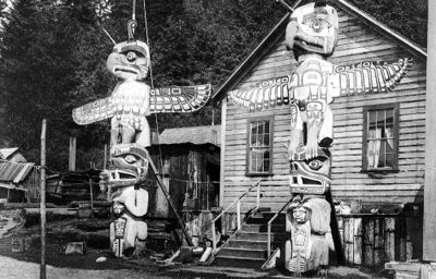
-
Article
Alexandria
Alexandria, ON, population centre, population 2,906 (2021 census), 2,845 (2016 census). Incorporated as a town in 1903, Alexandria lost this status in 1998 as the result of municipal restructuring in Ontario. It is now part of the new township of North Glengarry (population 10,109). Alexandria is located midway on the Canadian National Railway line between Montreal and Ottawa.
"https://thecanadianencyclopedia.ca/images/tce_placeholder.jpg?v=e9dca980c9bdb3aa11e832e7ea94f5d9" // resources/views/front/categories/view.blade.php
https://thecanadianencyclopedia.ca/images/tce_placeholder.jpg?v=e9dca980c9bdb3aa11e832e7ea94f5d9
-
Article
Alma
Born of the lumber industry in 1860, Alma quickly became a prosperous agricultural parish. It burst into the industrial age in 1923 with the start of construction of the Isle-Maligne hydro station on the Grande Décharge.
"https://thecanadianencyclopedia.ca/images/tce_placeholder.jpg?v=e9dca980c9bdb3aa11e832e7ea94f5d9" // resources/views/front/categories/view.blade.php
https://thecanadianencyclopedia.ca/images/tce_placeholder.jpg?v=e9dca980c9bdb3aa11e832e7ea94f5d9
-
Article
Altona
The town site was established in 1895 on a Canadian Pacific Railway spur near the agricultural village of Altona, settled in 1880 as part of a reserve W of the Red River for Mennonites from Russia.
"https://thecanadianencyclopedia.ca/images/tce_placeholder.jpg?v=e9dca980c9bdb3aa11e832e7ea94f5d9" // resources/views/front/categories/view.blade.php
https://thecanadianencyclopedia.ca/images/tce_placeholder.jpg?v=e9dca980c9bdb3aa11e832e7ea94f5d9
-
Article
Amherst
Amherst, NS, incorporated as a town in 1889, population 9717 (2011c), 9505 (2006c). The Town of Amherst is located near the border with New Brunswick, 15 km east of Sackville, NB.
"https://thecanadianencyclopedia.ca/images/tce_placeholder.jpg?v=e9dca980c9bdb3aa11e832e7ea94f5d9" // resources/views/front/categories/view.blade.php
https://thecanadianencyclopedia.ca/images/tce_placeholder.jpg?v=e9dca980c9bdb3aa11e832e7ea94f5d9
-
Article
Amherstburg
Amherstburg, Ontario, incorporated as a town in 1878, population 21,936 (2016 census), 21,556 (2011 census). The town of Amherstburg is located on the Detroit River near Lake Erie. It is located on the traditional territory of the Three Fires Confederacy, which includes Ojibwe, Odawa and Potawatomi peoples (see also Anishinaabe). The land is covered by Treaty 35. During the 1850s, Amherstburg was a principal terminus of the Underground Railroad.
"https://d3d0lqu00lnqvz.cloudfront.net/media/new_article_images/Amherstburg/a163923.jpg" // resources/views/front/categories/view.blade.php
https://d3d0lqu00lnqvz.cloudfront.net/media/new_article_images/Amherstburg/a163923.jpg
-
Article
Amos
Amos, Quebec, incorporated as a town in 1925, population 12,675 (2021 census), 12,823 (2016 census). Amos is located 110 km northeast of Rouyn-Noranda in northwestern Quebec.
"https://thecanadianencyclopedia.ca/images/tce_placeholder.jpg?v=e9dca980c9bdb3aa11e832e7ea94f5d9" // resources/views/front/categories/view.blade.php
https://thecanadianencyclopedia.ca/images/tce_placeholder.jpg?v=e9dca980c9bdb3aa11e832e7ea94f5d9
-
Article
Ancaster
Ancaster, Ont, Urban Community within the city of Hamilton. Ancaster was incorporated as a town in 1974, but in 2001 it was merged into the new city of Hamilton
"https://d3d0lqu00lnqvz.cloudfront.net/media/media/1194fa19-eac7-4c16-9da5-aa886cf834f5.jpg" // resources/views/front/categories/view.blade.php
https://d3d0lqu00lnqvz.cloudfront.net/media/media/1194fa19-eac7-4c16-9da5-aa886cf834f5.jpg