
Browse "Geographical Features"
-
Article
Aberdeen Lake
Aberdeen Lake, 1100 km2, elev 80 m, maximum length 91 km, is located in Nunavut, 213 km south of the Arctic Circle.
"https://thecanadianencyclopedia.ca/images/tce_placeholder.jpg?v=e9dca980c9bdb3aa11e832e7ea94f5d9" // resources/views/front/categories/view.blade.php
https://thecanadianencyclopedia.ca/images/tce_placeholder.jpg?v=e9dca980c9bdb3aa11e832e7ea94f5d9
-
"https://thecanadianencyclopedia.ca/images/tce_placeholder.jpg?v=e9dca980c9bdb3aa11e832e7ea94f5d9" // resources/views/front/categories/view.blade.php
https://thecanadianencyclopedia.ca/images/tce_placeholder.jpg?v=e9dca980c9bdb3aa11e832e7ea94f5d9
-
Article
Allison Pass
Allison Pass, elevation 1,352 metres, is located at kilometre 60, the highest point on the Hope-Princeton Highway (opened 1949) through the Cascade Mountains of southern British Columbia.
"https://thecanadianencyclopedia.ca/images/tce_placeholder.jpg?v=e9dca980c9bdb3aa11e832e7ea94f5d9" // resources/views/front/categories/view.blade.php
https://thecanadianencyclopedia.ca/images/tce_placeholder.jpg?v=e9dca980c9bdb3aa11e832e7ea94f5d9
-
Article
Alsek River
The Alsek River originates in the highest mountains in Canada, the St Elias Range.
"https://thecanadianencyclopedia.ca/images/tce_placeholder.jpg?v=e9dca980c9bdb3aa11e832e7ea94f5d9" // resources/views/front/categories/view.blade.php
https://thecanadianencyclopedia.ca/images/tce_placeholder.jpg?v=e9dca980c9bdb3aa11e832e7ea94f5d9
-
Article
Amadjuak Lake
Amadjuak Lake, 3115 km2, elevation 113 m, is one of 2 lakes situated in the Great Plain of the Koukdjuak in south-central Baffin Island. This lower-lying area only emerged recently (in geological terms) from beneath the waters of Foxe Basin. Amadjuak Lake is the third-largest in Nunavut.
"https://thecanadianencyclopedia.ca/images/tce_placeholder.jpg?v=e9dca980c9bdb3aa11e832e7ea94f5d9" // resources/views/front/categories/view.blade.php
https://thecanadianencyclopedia.ca/images/tce_placeholder.jpg?v=e9dca980c9bdb3aa11e832e7ea94f5d9
-
Article
Amund Ringnes Island
Amund Ringnes Island, 5255 km2, located between Ellef Ringnes and Axel Heiberg islands in the Arctic Archipelago. It is flat (highest point about 610 m) and windswept; in winter its coasts are virtually indistinguishable from the surrounding ice.
"https://thecanadianencyclopedia.ca/images/tce_placeholder.jpg?v=e9dca980c9bdb3aa11e832e7ea94f5d9" // resources/views/front/categories/view.blade.php
https://thecanadianencyclopedia.ca/images/tce_placeholder.jpg?v=e9dca980c9bdb3aa11e832e7ea94f5d9
-
Article
Anderson River
Anderson River, 692 km long, originates in a group of lakes north of Great Bear Lake in the Northwest Territories and meanders north and west to empty into Liverpool Bay, an arm of the Beaufort Sea, just east of the Mackenzie Delta.
"https://thecanadianencyclopedia.ca/images/tce_placeholder.jpg?v=e9dca980c9bdb3aa11e832e7ea94f5d9" // resources/views/front/categories/view.blade.php
https://thecanadianencyclopedia.ca/images/tce_placeholder.jpg?v=e9dca980c9bdb3aa11e832e7ea94f5d9
-
Article
Annapolis Lowlands
Following the retreat of glacial ice, about 13 000 years ago, the lowlands were nearly completely flooded by the sea to a height of 30 m.
"https://thecanadianencyclopedia.ca/images/tce_placeholder.jpg?v=e9dca980c9bdb3aa11e832e7ea94f5d9" // resources/views/front/categories/view.blade.php
https://thecanadianencyclopedia.ca/images/tce_placeholder.jpg?v=e9dca980c9bdb3aa11e832e7ea94f5d9
-
Article
Anse du Cap des Rosiers
Anse du Cap des Rosiers [Fr, "cove of the cape of rosebushes"] was named for the many wild rosebushes found there. The cape that forms the bay is a steep and shrub-covered promontory.
"https://thecanadianencyclopedia.ca/images/tce_placeholder.jpg?v=e9dca980c9bdb3aa11e832e7ea94f5d9" // resources/views/front/categories/view.blade.php
https://thecanadianencyclopedia.ca/images/tce_placeholder.jpg?v=e9dca980c9bdb3aa11e832e7ea94f5d9
-
Article
Anthony Island
The overgrowth of lush vegetation has been cleared away from the remains of Ninstints's longhouses and totem poles, which pay silent homage to their creators.
"https://d3d0lqu00lnqvz.cloudfront.net/media/media/1c61ad08-f404-4f01-83ee-d9b43e4b833b.jpg" // resources/views/front/categories/view.blade.php
https://d3d0lqu00lnqvz.cloudfront.net/media/media/1c61ad08-f404-4f01-83ee-d9b43e4b833b.jpg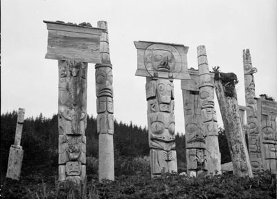
-
Article
Athabasca Landing Trail
Athabasca Landing Trail was established 1875 by Hudson's Bay Company between Edmonton and Athabasca Landing to improve and expand northern transportation.
"https://d3d0lqu00lnqvz.cloudfront.net/media/media/86a45811-ca7b-4681-85e6-0f4769979844.jpg" // resources/views/front/categories/view.blade.php
https://d3d0lqu00lnqvz.cloudfront.net/media/media/86a45811-ca7b-4681-85e6-0f4769979844.jpg
-
Article
Athabasca Pass
Athabasca Pass, elevation 1,748 m, is situated on the extreme southwest boundary of Jasper National Park, on the British Columbia-Alberta border.
"https://thecanadianencyclopedia.ca/images/tce_placeholder.jpg?v=e9dca980c9bdb3aa11e832e7ea94f5d9" // resources/views/front/categories/view.blade.php
https://thecanadianencyclopedia.ca/images/tce_placeholder.jpg?v=e9dca980c9bdb3aa11e832e7ea94f5d9
-
Article
Atlin Lake
Atlin Lake, 775 km2, elev 668 m, is a long, narrow lake in northwestern BC touching the Yukon border. The source of the Yukon River, it was inundated by prospectors during the Klondike Gold Rush 1897-98. The town of Atlin is on the E shore.
"https://thecanadianencyclopedia.ca/images/tce_placeholder.jpg?v=e9dca980c9bdb3aa11e832e7ea94f5d9" // resources/views/front/categories/view.blade.php
https://thecanadianencyclopedia.ca/images/tce_placeholder.jpg?v=e9dca980c9bdb3aa11e832e7ea94f5d9
-
Article
Attawapiskat River
Attawapiskat River, 748 km long, formed by the confluence of the Pineimuta, Trading and Otoskwin rivers at Attawapiskat Lake, in northeastern Ontario, flows east, jogs north and runs east to the flatland by James Bay. Its drainage area is 50 200 km2 and its mean discharge 626 m3/s.
"https://thecanadianencyclopedia.ca/images/tce_placeholder.jpg?v=e9dca980c9bdb3aa11e832e7ea94f5d9" // resources/views/front/categories/view.blade.php
https://thecanadianencyclopedia.ca/images/tce_placeholder.jpg?v=e9dca980c9bdb3aa11e832e7ea94f5d9
-
Article
Avalon Peninsula
Avalon Peninsula, 9220 km2, is a spreading peninsula thrust out into the rich fishing grounds of the north Atlantic, forming the southeast corner of insular Newfoundland.
"https://d3d0lqu00lnqvz.cloudfront.net/media/media/9174fc30-b6b6-4ab0-b12f-9fbca2dab7b8.jpg" // resources/views/front/categories/view.blade.php
https://d3d0lqu00lnqvz.cloudfront.net/media/media/9174fc30-b6b6-4ab0-b12f-9fbca2dab7b8.jpg