
Browse "Places"
-
Article
Carberry
Carberry's major economic activity was agriculture. However, it has also became well known for the natural areas close by, especially Spruce Woods Provincial Park and Forest.
"https://d3d0lqu00lnqvz.cloudfront.net/media/media/297176a0-0a84-436d-8bed-f000351be839.jpg" // resources/views/front/categories/view.blade.php
https://d3d0lqu00lnqvz.cloudfront.net/media/media/297176a0-0a84-436d-8bed-f000351be839.jpg
-
Article
Carbonear
Carbonear, NL, incorporated as a town in 1948, population 4739 (2011c), 4723 (2006c). The Town of Carbonear is located on the west shore of Conception Bay and is one of the oldest settlements in Newfoundland and Labrador.
"https://thecanadianencyclopedia.ca/images/tce_placeholder.jpg?v=e9dca980c9bdb3aa11e832e7ea94f5d9" // resources/views/front/categories/view.blade.php
https://thecanadianencyclopedia.ca/images/tce_placeholder.jpg?v=e9dca980c9bdb3aa11e832e7ea94f5d9
-
Article
Carcross
Carcross, Yukon, settlement, population 301 (2016 census), 289 (2011 census). Carcross is a major Tagish and Tlingit community located at the north end of Bennett Lake, 74 km south of Whitehorse.
"https://thecanadianencyclopedia.ca/images/tce_placeholder.jpg?v=e9dca980c9bdb3aa11e832e7ea94f5d9" // resources/views/front/categories/view.blade.php
https://thecanadianencyclopedia.ca/images/tce_placeholder.jpg?v=e9dca980c9bdb3aa11e832e7ea94f5d9
-
Article
Cardigan
Cardigan, PEI, incorporated as a village in 1954 and as a community in 1983, population 332 (2011c), 374 (2006c). The Community of Cardigan is situated 54 km northeast of CHARLOTTETOWN. A fishing and farming community and the
"https://thecanadianencyclopedia.ca/images/tce_placeholder.jpg?v=e9dca980c9bdb3aa11e832e7ea94f5d9" // resources/views/front/categories/view.blade.php
https://thecanadianencyclopedia.ca/images/tce_placeholder.jpg?v=e9dca980c9bdb3aa11e832e7ea94f5d9
-
Article
Cardston
Cardston, Alberta, incorporated as a town in 1901, population 3,585 (2016 census), 3,580 (2011 census). The town of Cardston is located 75 km southwest of Lethbridge. It was named for Charles Ora Card (1839─1906), a son-in-law of Brigham Young. Young was a leader of the Church of Jesus Christ of the Latter Day Saints (see Mormon Church) in the United States.
"https://thecanadianencyclopedia.ca/images/tce_placeholder.jpg?v=e9dca980c9bdb3aa11e832e7ea94f5d9" // resources/views/front/categories/view.blade.php
https://thecanadianencyclopedia.ca/images/tce_placeholder.jpg?v=e9dca980c9bdb3aa11e832e7ea94f5d9
-
Article
Cariboo Mountains
The Cariboo Mountains is the most northern range making up the Columbia Mountains.
"https://d3d0lqu00lnqvz.cloudfront.net/cariboo-mountains-flora-1105422859_0a2bdb6663_b.jpg" // resources/views/front/categories/view.blade.php
https://d3d0lqu00lnqvz.cloudfront.net/cariboo-mountains-flora-1105422859_0a2bdb6663_b.jpg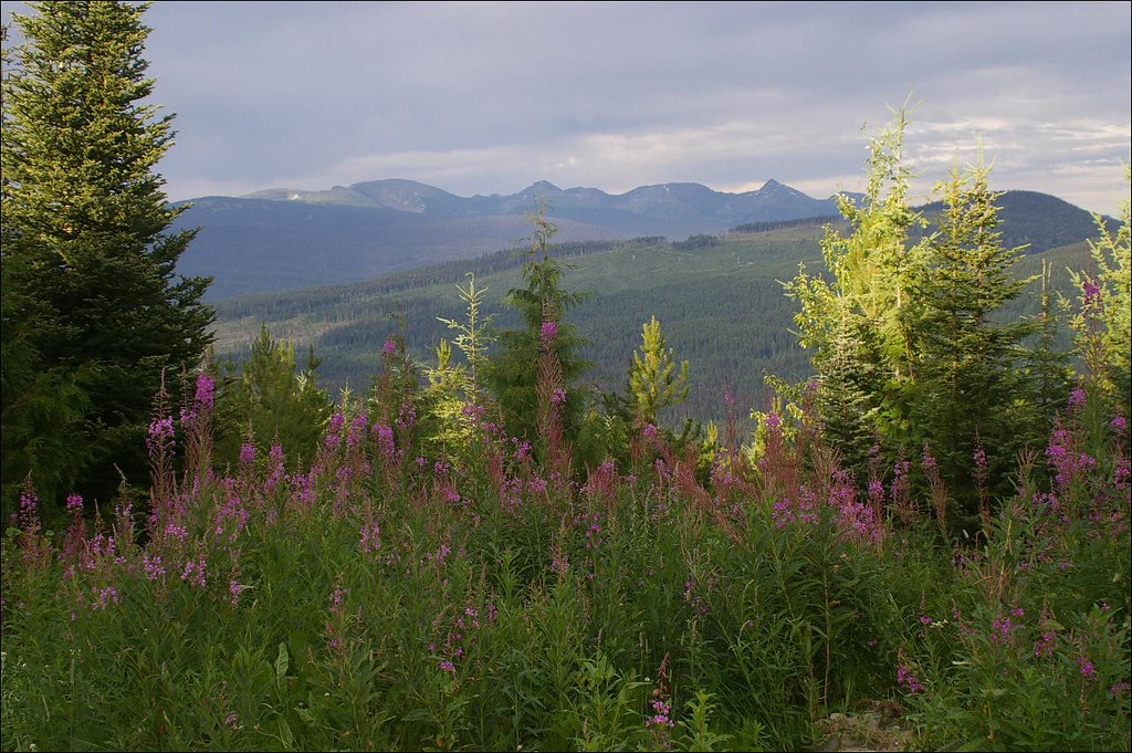
-
Article
Cariboo Road
A contingent of Royal Engineers was brought from Britain to survey the route from Yale, at the head of navigation on the Fraser River, along extremely treacherous terrain to the administrative centre of the Cariboo.
"https://d3d0lqu00lnqvz.cloudfront.net/media/media/59bb3c56-871c-4015-bd1e-85b23dc3f1f4.jpg" // resources/views/front/categories/view.blade.php
https://d3d0lqu00lnqvz.cloudfront.net/media/media/59bb3c56-871c-4015-bd1e-85b23dc3f1f4.jpg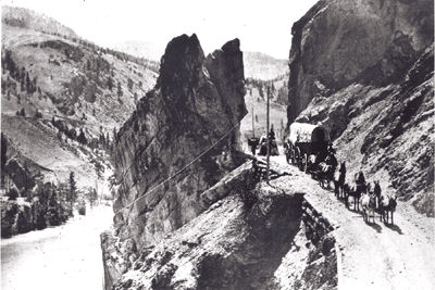
-
Article
Carleton Martello Tower National Historic Site of Canada
Located in Saint John, New Brunswick, Carleton Martello Tower National Historic Site sits on a commanding height of land dominating the surrounding landscape and harbour approaches. Built by the British during the War of 1812, the original 9-metre-high tower and gun deck measuring 15 metres across its base was intended to protect the western approaches to the city from a potential American attack.
"https://d3d0lqu00lnqvz.cloudfront.net/media/media/4963c3ae-2d47-43bb-bb46-f3cb653b9ea7.jpg" // resources/views/front/categories/view.blade.php
https://d3d0lqu00lnqvz.cloudfront.net/media/media/4963c3ae-2d47-43bb-bb46-f3cb653b9ea7.jpg
-
Article
Carleton Place
Carleton Place, Ont, incorporated as a town in 1890, population 9809 (2011c), 9453 (2006c). The Town of Carleton Place, located on the Mississippi River, 45 km southwest of OTTAWA.
"https://thecanadianencyclopedia.ca/images/tce_placeholder.jpg?v=e9dca980c9bdb3aa11e832e7ea94f5d9" // resources/views/front/categories/view.blade.php
https://thecanadianencyclopedia.ca/images/tce_placeholder.jpg?v=e9dca980c9bdb3aa11e832e7ea94f5d9
-
Article
Carmacks
Carmacks, Yukon, incorporated as a village in 1984, population 493 (2016 census), 503 (2011 census). The village of Carmacks is located on the Yukon River at the mouth of the Nordenskiold River, 175 km downstream from Whitehorse.
"https://thecanadianencyclopedia.ca/images/tce_placeholder.jpg?v=e9dca980c9bdb3aa11e832e7ea94f5d9" // resources/views/front/categories/view.blade.php
https://thecanadianencyclopedia.ca/images/tce_placeholder.jpg?v=e9dca980c9bdb3aa11e832e7ea94f5d9
-
Article
Carman
Carman, Manitoba, incorporated as a town in 1905, population 3027 (2011c), 2781 (2006c). The Town of Carman, located 80 km southwest of WINNIPEG on the Boyne River in the Pembina Triangle, is one of the most prosperous agricultural districts in Manitoba.
"https://thecanadianencyclopedia.ca/images/tce_placeholder.jpg?v=e9dca980c9bdb3aa11e832e7ea94f5d9" // resources/views/front/categories/view.blade.php
https://thecanadianencyclopedia.ca/images/tce_placeholder.jpg?v=e9dca980c9bdb3aa11e832e7ea94f5d9
-
Article
Cartography in Canada: 1500s
Most maps created in the 1500s that relate to Canada are manuscript compilations, often undated and anonymous. They were prepared by European cartographers rather than by explorers. Since cartographers had to work with available material, these maps are at times a perplexing mixture of new information and old, copied from unspecified sources. Any review of the sequence in which Canada was first mapped is therefore somewhat conjectural. (See also History of Cartography in Canada.)
"https://d3d0lqu00lnqvz.cloudfront.net/media/new_article_images/CartographyInCanada1500s/CantinoChart1502.jpg" // resources/views/front/categories/view.blade.php
https://d3d0lqu00lnqvz.cloudfront.net/media/new_article_images/CartographyInCanada1500s/CantinoChart1502.jpg
-
Article
Cartwright
Cartwright, Newfoundland and Labrador, incorporated as a town in 1956, population 439 (2021 census), 427 (2016 census). The town of Cartwright is located at the mouth of Sandwich Bay on the south coast of Labrador.
"https://thecanadianencyclopedia.ca/images/tce_placeholder.jpg?v=e9dca980c9bdb3aa11e832e7ea94f5d9" // resources/views/front/categories/view.blade.php
https://thecanadianencyclopedia.ca/images/tce_placeholder.jpg?v=e9dca980c9bdb3aa11e832e7ea94f5d9
-
Article
Cascade Mountains
Cascade Mountains, BC, are the north end of largely volcanic mountain ranges extending to California, 180-260 km east of the Pacific Ocean. There are no active volcanoes in BC like the US Cascades' Mount St Helens and others.
"https://thecanadianencyclopedia.ca/images/tce_placeholder.jpg?v=e9dca980c9bdb3aa11e832e7ea94f5d9" // resources/views/front/categories/view.blade.php
https://thecanadianencyclopedia.ca/images/tce_placeholder.jpg?v=e9dca980c9bdb3aa11e832e7ea94f5d9
-
Article
Cassiar District
The Cassiar District lies in British Columbia's northwest corner; it historically encompasses the Stikine and Dease River watersheds and that of the upper Taku, NASS and Kechika.
"https://thecanadianencyclopedia.ca/images/tce_placeholder.jpg?v=e9dca980c9bdb3aa11e832e7ea94f5d9" // resources/views/front/categories/view.blade.php
https://thecanadianencyclopedia.ca/images/tce_placeholder.jpg?v=e9dca980c9bdb3aa11e832e7ea94f5d9