Browse "Places"
-
Article
Café Le Hibou
Café Le Hibou Coffee House was a renowned coffee house in Ottawa. Founded by Denis Faulkner, who ran it until 1968, it was in business from 1960 to 1975. It was an important venue for the folk music scene of the early 1960s. The café helped establish the ByWard Market as Ottawa’s trendy neighbourhood at a time when the city’s nightlife was virtually nonexistent. By the end of the 1960s, it was a frequent stop for big-name artists, musicians and celebrities. It entrenched café culture in Ottawa and helped major venues establish themselves nearby.
"https://thecanadianencyclopedia.ca/images/tce_placeholder.jpg?v=e9dca980c9bdb3aa11e832e7ea94f5d9" // resources/views/front/categories/view.blade.php
https://thecanadianencyclopedia.ca/images/tce_placeholder.jpg?v=e9dca980c9bdb3aa11e832e7ea94f5d9
-
Article
Caledon
Caledon, Ontario, incorporated as a city in 1974, population 76,581 (2021 census), 66,502 (2016 census). Northwest of Toronto, Caledon shares its border with nine other municipalities. Together with Brampton and Mississauga, it creates the Region of Peel. Up until recent decades, the area has been relatively rural. Today, however, it is in the midst of urbanization. Throughout history, the Caledon area has been home to different Indigenous groups, namely the Wendat (Huron), Tionontati (Petun), Haudenosaunee and Anishinaabeg, including the Mississaugas of the Credit First Nation. The land is part of the Ajetance Purchase (1818).
"https://d3d0lqu00lnqvz.cloudfront.net/Caledon/CaledonBadlands.jpg" // resources/views/front/categories/view.blade.php
https://d3d0lqu00lnqvz.cloudfront.net/Caledon/CaledonBadlands.jpg
-
Article
Calgary
Calgary, Alberta, incorporated as a city in 1894, population 1,306,784 (2021 census), 1,239,220 (2016 census). The city of Calgary is situated on the Bow River in southern Alberta, about 220 km north of the American border at the meeting point of the Western prairies and mountain foothills. It is the financial centre of western Canada, based on its key role in the development of the region’s oil and gas industry. With its panoramic backdrop of the Rocky Mountains and its historic association with cattle ranching and oil exploration, Calgary is one of Canada’s most identifiable cities.
"https://d3d0lqu00lnqvz.cloudfront.net/media/media/82e124db-7884-44c8-85c5-5696968ef38e.jpg" // resources/views/front/categories/view.blade.php
https://d3d0lqu00lnqvz.cloudfront.net/media/media/82e124db-7884-44c8-85c5-5696968ef38e.jpg
-
Article
Music in Calgary
Alberta city founded on or near the site of Fort la Jonquière which was built in 1751 at the junction of the Bow and Elbow rivers and was abandoned after 1785. Fort Brisebois, established there by the Northwest Mounted Police in 1875, was renamed Fort Calgary a year later.
"https://thecanadianencyclopedia.ca/images/tce_placeholder.jpg?v=e9dca980c9bdb3aa11e832e7ea94f5d9" // resources/views/front/categories/view.blade.php
https://thecanadianencyclopedia.ca/images/tce_placeholder.jpg?v=e9dca980c9bdb3aa11e832e7ea94f5d9
-
Article
Cambridge
Cambridge, Ontario, incorporated as a city in 1973, population 138,479 (2021 census), 129,920 (2016 census). Cambridge is located within Waterloo Region and along the Grand River. It was created through the amalgamation of the City of Galt, the Towns of Preston and Hespeler, and parts of North Dumfries and Waterloo townships. Throughout history, the Cambridge area has been home to different Indigenous groups, namely the Neutral, Haudenosaunee and Anishinaabe. The land is covered by the Haldimand Proclamation.
"https://d3d0lqu00lnqvz.cloudfront.net/Cambridge/GrandRiverCambridge.jpg" // resources/views/front/categories/view.blade.php
https://d3d0lqu00lnqvz.cloudfront.net/Cambridge/GrandRiverCambridge.jpg
-
Article
Cambridge Bay
Cambridge Bay, Nunavut, incorporated as a hamlet in 1984, population 1608 (2011c), 1477 (2006c). The Hamlet of Cambridge Bay is located on the southeast coast of VICTORIA ISLAND.
"https://thecanadianencyclopedia.ca/images/tce_placeholder.jpg?v=e9dca980c9bdb3aa11e832e7ea94f5d9" // resources/views/front/categories/view.blade.php
https://thecanadianencyclopedia.ca/images/tce_placeholder.jpg?v=e9dca980c9bdb3aa11e832e7ea94f5d9
-
Article
Camp X
Camp X — a popular name that reflects the secrecy surrounding its activities — was a training school for covert agents and a radio communications centre that operated close to Whitby, Ontario, during the Second World War. It was the first such purpose-built facility constructed in North America. Known officially as STS (Special Training School) 103, Camp X was one of several dozen around the world that served the needs of the Special Operations Executive (SOE), the British agency created in 1940 to “set Europe ablaze” by promoting sabotage and subversion behind enemy lines. The radio communications centre, with its high-speed transmitter known as Hydra, was closely linked with British Security Co-Ordination (BSC), the New York-based agency directed by the Winnipeg-born businessman William Stephenson. Soviet defector Igor Gouzenko was hidden there after his defection in September 1945.
"https://d3d0lqu00lnqvz.cloudfront.net/media/media/29e7f4d4-b408-4532-8c5f-c3aa1874cc0c.jpg" // resources/views/front/categories/view.blade.php
https://d3d0lqu00lnqvz.cloudfront.net/media/media/29e7f4d4-b408-4532-8c5f-c3aa1874cc0c.jpg
-
Article
Campbell River
Campbell River, BC, incorporated as a city in 2005, population 31 186 (2011c), 29 572 (2006c). The City of Campbell River was formerly a village (1947) and a district municipality (1964) before receiving civic status in 2005.
"https://thecanadianencyclopedia.ca/images/tce_placeholder.jpg?v=e9dca980c9bdb3aa11e832e7ea94f5d9" // resources/views/front/categories/view.blade.php
https://thecanadianencyclopedia.ca/images/tce_placeholder.jpg?v=e9dca980c9bdb3aa11e832e7ea94f5d9
-
Article
Campbellton
Campbellton, New Brunswick, incorporated as a city in 1958, population 7,047 (2021 census), 6,883 (2016 census). The City of Campbellton is the administrative centre of Restigouche County. Campbellton is located on the Quebec border near the mouth of the Restigouche River. The population is nearly evenly split, being either English-speaking or French-speaking.
"https://thecanadianencyclopedia.ca/images/tce_placeholder.jpg?v=e9dca980c9bdb3aa11e832e7ea94f5d9" // resources/views/front/categories/view.blade.php
https://thecanadianencyclopedia.ca/images/tce_placeholder.jpg?v=e9dca980c9bdb3aa11e832e7ea94f5d9
-
Article
Campobello Island
Campobello Island abuts the border with the US in PASSAMAQUODDY BAY , on the south coast of New Brunswick. Sovereignty over the ruggedly picturesque island was early in dispute, but passed to NB by convention in 1817. The
"https://d3d0lqu00lnqvz.cloudfront.net/media/media/364b3dab-46ce-450c-8e44-125fe9dd20d3.jpg" // resources/views/front/categories/view.blade.php
https://d3d0lqu00lnqvz.cloudfront.net/media/media/364b3dab-46ce-450c-8e44-125fe9dd20d3.jpg
-
Article
Camrose
Camrose, Alberta, incorporated as a city in 1955, population 18,742 (2016 census), 17,286 (2011 census). The city of Camrose, located 97 km southeast of Edmonton, is a distributing, medical, government and manufacturing centre for a rich, mixed-farming area.
"https://thecanadianencyclopedia.ca/images/tce_placeholder.jpg?v=e9dca980c9bdb3aa11e832e7ea94f5d9" // resources/views/front/categories/view.blade.php
https://thecanadianencyclopedia.ca/images/tce_placeholder.jpg?v=e9dca980c9bdb3aa11e832e7ea94f5d9
-
Article
Canada
The name “Canada,” is derived from the Iroquoian word kanata, meaning a village or settlement. On 13 August 1535, as Jacques Cartier was nearing Île d'Anticosti, two Indigenous youths he was bringing back from France informed him that the route to Canada (“chemin de Canada”) lay to the south of the island. By Canada they meant the village of Stadacona, on the future site of Quebec City. Cartier used the word in that sense, but also referred to “the province of Canada,” meaning the area subject to Donnacona, chief at Stadacona. The name was soon applied to a much larger region. The “Harleian” world map of c. 1547, the first to show the discoveries made on Cartier's second voyage, applied it to an area north of the gulf and river St. Lawrence. By 1550 maps were also placing the name south of the river. (See also Cartography in Canada: 1500s.)
"https://d3d0lqu00lnqvz.cloudfront.net/media/new_article_images/CartographyInCanada1500s/DesceliersMap1546.jpg" // resources/views/front/categories/view.blade.php
https://d3d0lqu00lnqvz.cloudfront.net/media/new_article_images/CartographyInCanada1500s/DesceliersMap1546.jpg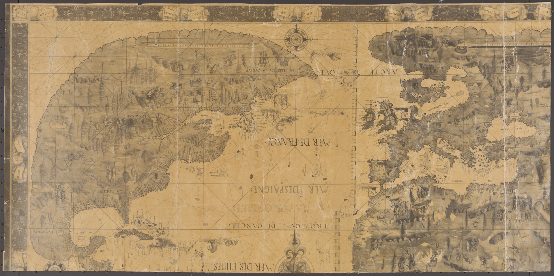
-
Article
Canada Agriculture and Food Museum
The Canada Agriculture and Food Museum officially opened in 1983 and is located on the Central Experimental Farm site in Ottawa, Ontario. The Canada Agriculture and Food Museum seeks to fulfil its role as a national museum by connecting Canadians and international visitors to the historical and ongoing importance of agricultural science and technology in everyday life (see Agriculture in Canada). It accomplishes this mandate through the creation of engaging interpretive activities and products centred on an accessible demonstration farm.
"https://d3d0lqu00lnqvz.cloudfront.net/TCE_placeholder.png" // resources/views/front/categories/view.blade.php
https://d3d0lqu00lnqvz.cloudfront.net/TCE_placeholder.png
-
Article
Canada Aviation and Space Museum
The Canada Aviation and Space Museum has the most extensive aviation collection in Canada. Located in Ottawa, the museum focuses on the history of Canadian aviation in an international context. Its collection includes more than 130 aircraft and artifacts.
"https://d3d0lqu00lnqvz.cloudfront.net/media/media/8e9fd784-494b-45e6-8b61-9ddb0f1d563d.jpg" // resources/views/front/categories/view.blade.php
https://d3d0lqu00lnqvz.cloudfront.net/media/media/8e9fd784-494b-45e6-8b61-9ddb0f1d563d.jpg
-
Article
Canada East
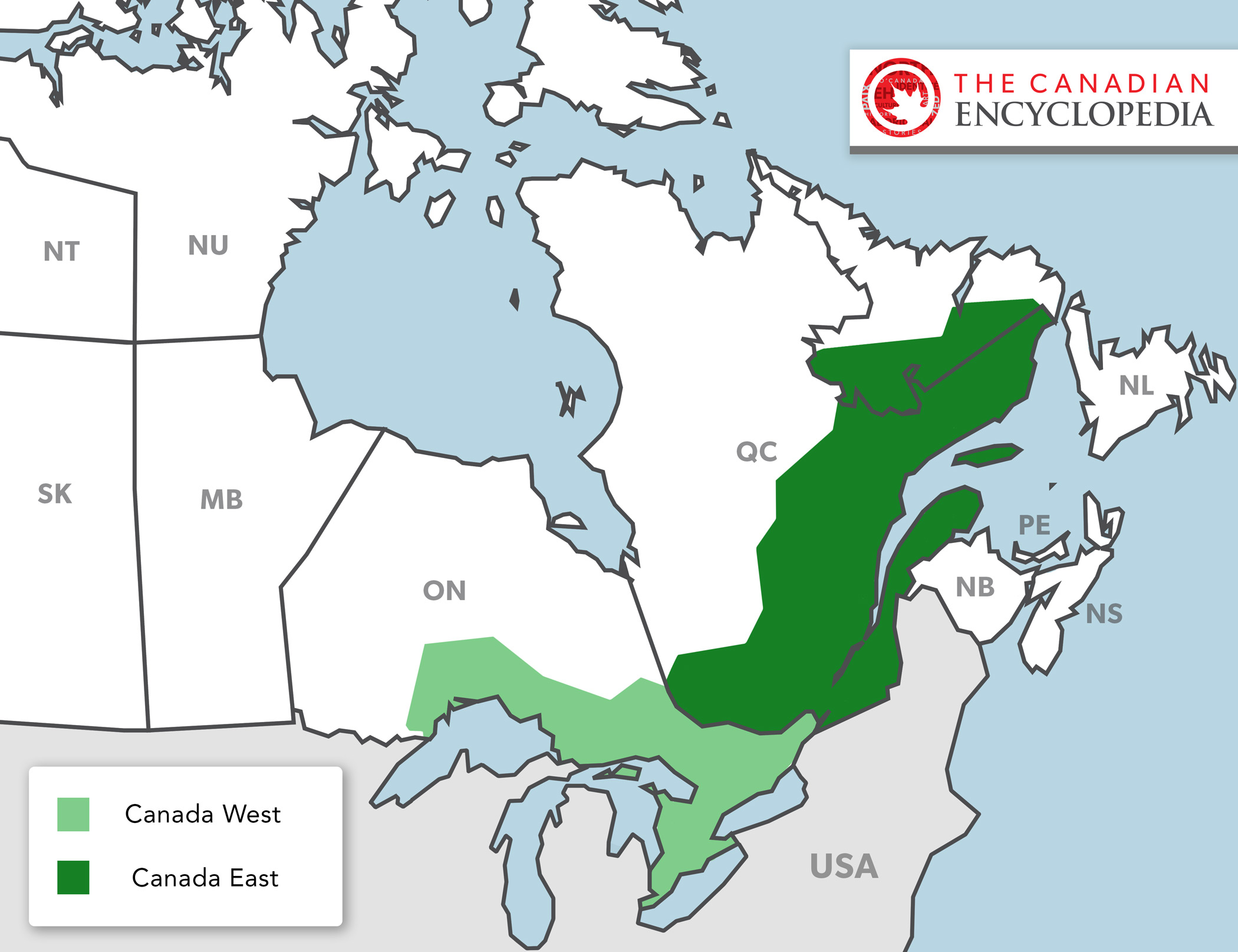
In 1841, Britain united the colonies of Upper and Lower Canada into the Province of Canada. This was in response to the violent rebellions of 1837–38. The Durham Report (1839) laid out the guidelines to create the new colony with the Act of Union in 1840. The Province of Canada was made up of Canada West (formerly Upper Canada) and Canada East (formerly Lower Canada). The two regions were governed jointly until Confederation in 1867. Canada West then became Ontario and Canada East became Quebec.
"https://d3d0lqu00lnqvz.cloudfront.net/media/new_article_images/PoliticsInOntario/Map_Canada_West_East.jpg" // resources/views/front/categories/view.blade.php
https://d3d0lqu00lnqvz.cloudfront.net/media/new_article_images/PoliticsInOntario/Map_Canada_West_East.jpg