
Browse "Things"
-
Article
Fort Amherstburg and the War of 1812
A key site for controlling the western theatre of the War of 1812, Fort Amherstburg (now Fort Malden) owed its existence to the shifting boundaries on Lake Superior in the wake of British and American diplomatic and military disputes.
"https://d3d0lqu00lnqvz.cloudfront.net/media/media/d474d1e9-393d-4930-9241-243d33a89ef3.jpg" // resources/views/front/categories/view.blade.php
https://d3d0lqu00lnqvz.cloudfront.net/media/media/d474d1e9-393d-4930-9241-243d33a89ef3.jpg
-
Article
Fort Anne
For the next 40 years, the British at Fort Anne maintained a precarious position in the Acadian-dominated province and were frequently attacked by French and Indigenou raiding parties. The status of the fort declined with the founding of Halifax (1749) and the expulsion of the Acadians (1755).
"https://d3d0lqu00lnqvz.cloudfront.net/media/media/8cd2ef08-9dc5-4094-8da3-129abfe25600.jpg" // resources/views/front/categories/view.blade.php
https://d3d0lqu00lnqvz.cloudfront.net/media/media/8cd2ef08-9dc5-4094-8da3-129abfe25600.jpg
-
Article
Fort Beauséjour
Fort Beauséjour, on the west bank of the Missaguash River near present-day Sackville, New Brunswick was built 1751-55 by the French as a counter to nearby British Fort Lawrence (near Amherst, NS).
"https://thecanadianencyclopedia.ca/images/tce_placeholder.jpg?v=e9dca980c9bdb3aa11e832e7ea94f5d9" // resources/views/front/categories/view.blade.php
https://thecanadianencyclopedia.ca/images/tce_placeholder.jpg?v=e9dca980c9bdb3aa11e832e7ea94f5d9
-
Article
Fort Chambly
Fort Chambly is a historic fort located on the Richelieu River at Chambly, Quebec. It was an important defensive post in the Iroquois Wars, Anglo-French Wars (including the War of the Spanish Succession and the Seven Years’ War), American Revolution, War of 1812 and Rebellions of 1837–38. In 1920, it was designated a national historic site. The Fort Chambly National Historic Site includes a museum and interpretive centre.
"https://d3d0lqu00lnqvz.cloudfront.net/American-Revolution/Fort-Chambly.jpg" // resources/views/front/categories/view.blade.php
https://d3d0lqu00lnqvz.cloudfront.net/American-Revolution/Fort-Chambly.jpg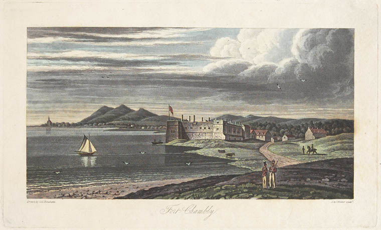
-
Article
Fort Duquesne
Fort Duquesne, located at the confluence of the Allegheny and Monongahela Rivers at the site of present-day Pittsburgh, Penn, guarded the most important strategic location in the west at the time of the Seven Years' War.
"https://thecanadianencyclopedia.ca/images/tce_placeholder.jpg?v=e9dca980c9bdb3aa11e832e7ea94f5d9" // resources/views/front/categories/view.blade.php
https://thecanadianencyclopedia.ca/images/tce_placeholder.jpg?v=e9dca980c9bdb3aa11e832e7ea94f5d9
-
Article
Fort Edmonton
Fort Edmonton was established on the Northern Saskatchewan River in 1795 by the Hudson's Bay Company as a fortified trading post next to the rival North West Company, which had earlier built its own fort nearby.
"https://d3d0lqu00lnqvz.cloudfront.net/media/media/59b16b11-e6be-4cf9-812f-126f5a933c3f.jpg" // resources/views/front/categories/view.blade.php
https://d3d0lqu00lnqvz.cloudfront.net/media/media/59b16b11-e6be-4cf9-812f-126f5a933c3f.jpg
-
Article
Fort Ellice
Fort Ellice was a Hudson's Bay Company trading post located on Beaver Creek near the confluence of the Assiniboine and Qu'Appelle rivers, just east of the present-day Manitoba-Saskatchewan border. Established in 1831 by C.T.
"https://thecanadianencyclopedia.ca/images/tce_placeholder.jpg?v=e9dca980c9bdb3aa11e832e7ea94f5d9" // resources/views/front/categories/view.blade.php
https://thecanadianencyclopedia.ca/images/tce_placeholder.jpg?v=e9dca980c9bdb3aa11e832e7ea94f5d9
-
Article
Fort Frances Case
In 1917, under the WAR MEASURES ACT, the government fixed the price and quantity of newsprint paper produced; subsequent legislation created the Paper Control Tribunal, which set retroactive prices through 1919, although wartime conditions had ceased.
"https://thecanadianencyclopedia.ca/images/tce_placeholder.jpg?v=e9dca980c9bdb3aa11e832e7ea94f5d9" // resources/views/front/categories/view.blade.php
https://thecanadianencyclopedia.ca/images/tce_placeholder.jpg?v=e9dca980c9bdb3aa11e832e7ea94f5d9
-
Article
Fort Frontenac
Frontenac reoccupied the site, rebuilding the fort in 1695, and the post became known as Fort Frontenac. Reinforced by troops under François-Charles de Bourlamaque and later the Marquis de MONTCALM, it nevertheless fell to the British under John Bradstreet in August 1758.
"https://d3d0lqu00lnqvz.cloudfront.net/media/media/224b2211-a1a9-4b89-888f-fab9972af144.jpg" // resources/views/front/categories/view.blade.php
https://d3d0lqu00lnqvz.cloudfront.net/media/media/224b2211-a1a9-4b89-888f-fab9972af144.jpg
-
Article
Fort Haldimand
Fort Haldimand, located on the west promontory of Carleton Island at the east end of Lake Ontario, about 16 km offshore from Kingston, Ontario, was built by the British in 1778 during the American Revolution.
"https://thecanadianencyclopedia.ca/images/tce_placeholder.jpg?v=e9dca980c9bdb3aa11e832e7ea94f5d9" // resources/views/front/categories/view.blade.php
https://thecanadianencyclopedia.ca/images/tce_placeholder.jpg?v=e9dca980c9bdb3aa11e832e7ea94f5d9
-
Article
Fort Henry
Fort Henry, KINGSTON, Ont, was originally built during the WAR OF 1812 on Point Henry, beside Lake Ontario, to guard the outlet to the St Lawrence River and the Kingston Navy Yards.
"https://d3d0lqu00lnqvz.cloudfront.net/media/media/c4427c9c-96dd-4f5c-bb92-6c22ac423cb3.jpg" // resources/views/front/categories/view.blade.php
https://d3d0lqu00lnqvz.cloudfront.net/media/media/c4427c9c-96dd-4f5c-bb92-6c22ac423cb3.jpg
-
Article
Fort la Reine
Fort la Reine is the name used for a series of early French fur-trade posts located west of Winnipeg on the Assiniboine River. The original fort was established in 1738 by Pierre Gaultier de Varennes et de La Vérendrye and his sons, independent fur traders and explorers.
"https://thecanadianencyclopedia.ca/images/tce_placeholder.jpg?v=e9dca980c9bdb3aa11e832e7ea94f5d9" // resources/views/front/categories/view.blade.php
https://thecanadianencyclopedia.ca/images/tce_placeholder.jpg?v=e9dca980c9bdb3aa11e832e7ea94f5d9
-
Article
Fort Mackinac
Fort Mackinac, located on Mackinac Island, is the third fort to guard the Straits of Mackinac. It was a strategic centre in the Upper Great Lakes from 1780 to 1895. The British constructed the fort from 1780 to 1781 during the American Revolution. Fort Mackinac’s position on the island’s bluffs was designed to offer a strong defensive position as well as defend the village of Mackinac and anchorage of Haldimand Bay. It was transferred to American control in 1796, captured by the British during the War of 1812, and returned to the US in 1814. It remained a military post until 1895.
"https://d3d0lqu00lnqvz.cloudfront.net/MichilimackinacIslandTreaty/Fort_Mackinac2_web.jpg" // resources/views/front/categories/view.blade.php
https://d3d0lqu00lnqvz.cloudfront.net/MichilimackinacIslandTreaty/Fort_Mackinac2_web.jpg
-
Article
Fort Michilimackinac
Fort Michilimackinac is located on the south side of the Straits of Mackinac. It sits on a sand beach in the northernmost extension of the Lower Peninsula of Michigan. Michilimackinac was the second fort to guard the Straits of Mackinac. The fort was a key trade, military, and diplomatic post for the French (1715–61) and the British (1761–81). The fort’s buildings were moved by the British in 1780-1 to a more defensible location on Mackinac Island. Fort Michilimackinac was reconstructed in the 20th century and serves as a living history museum in Michigan.
"https://d3d0lqu00lnqvz.cloudfront.net/Michilimackinac/Michilimackinac-State-Park-buildings.jpg" // resources/views/front/categories/view.blade.php
https://d3d0lqu00lnqvz.cloudfront.net/Michilimackinac/Michilimackinac-State-Park-buildings.jpg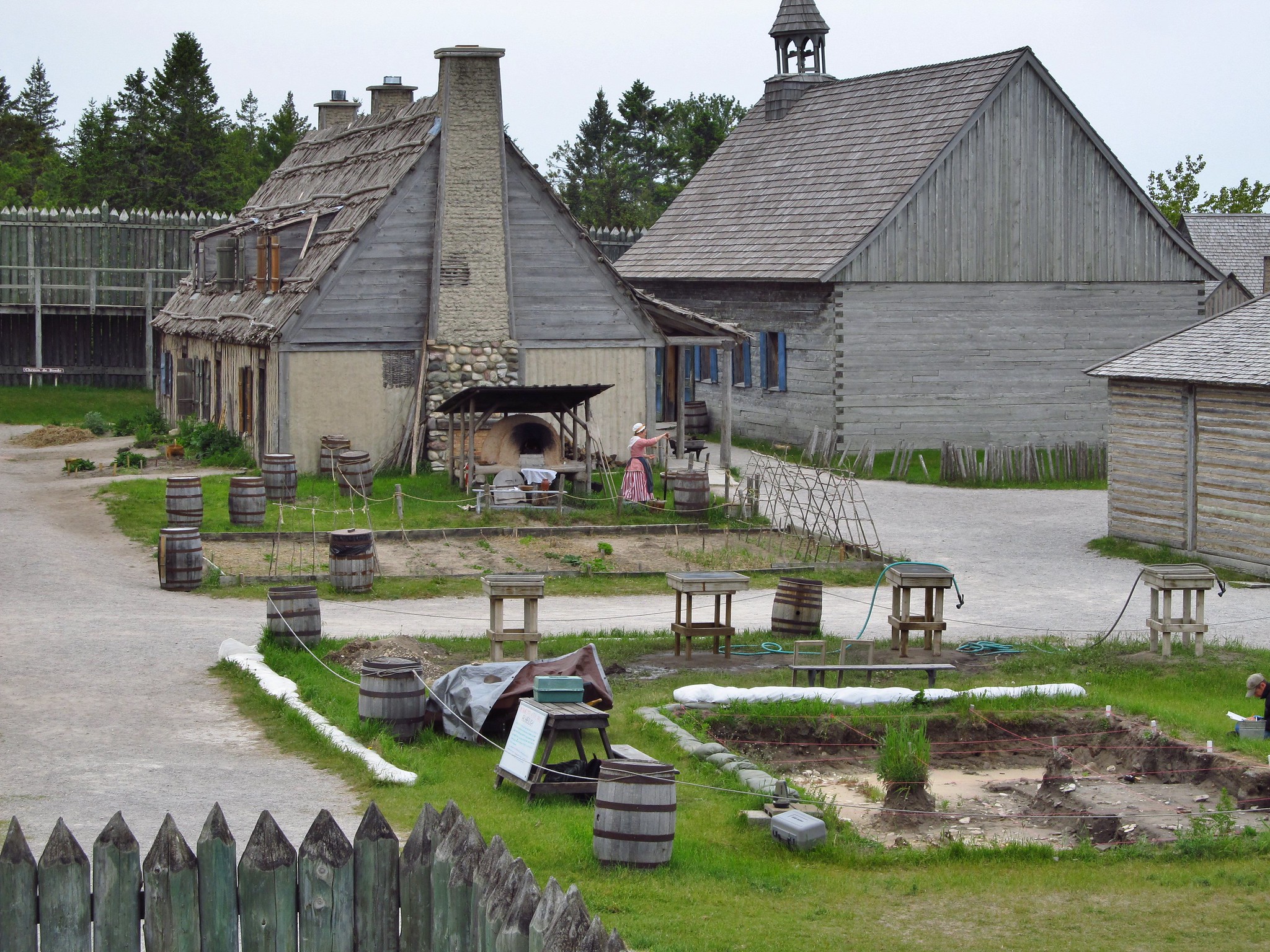
-
Article
Fort Niagara
Fort Niagara is situated on the east side of the Niagara River at Lake Ontario north of Youngstown, New York. It was built by the French in 1726–27 and surrendered to the British in 1759 during the Seven Years’ War. Fort Niagara was a major British supply depot during the American Revolution but was later transferred to the United States. It was an important American staging area during the War of 1812 but was captured by the British in 1813. Today it is a New York State historic site.
"https://d3d0lqu00lnqvz.cloudfront.net/media/media/659c26df-741b-477d-8d28-b5a7c4212206.jpg" // resources/views/front/categories/view.blade.php
https://d3d0lqu00lnqvz.cloudfront.net/media/media/659c26df-741b-477d-8d28-b5a7c4212206.jpg