
Browse "Places"
-
Article
Nickle Arts Museum
Nickle Arts Museum started with a philanthropic gesture. In 1970, on the occasion of his 81st birthday, Alberta oil pioneer Samuel C. Nickle gave the University of Calgary $1 million which the Alberta government matched.
"https://thecanadianencyclopedia.ca/images/tce_placeholder.jpg?v=e9dca980c9bdb3aa11e832e7ea94f5d9" // resources/views/front/categories/view.blade.php
https://thecanadianencyclopedia.ca/images/tce_placeholder.jpg?v=e9dca980c9bdb3aa11e832e7ea94f5d9
-
Article
Nicolet
In the early 19th century it became a major agricultural town and an important crossroads for the townships of the S shore. With its economic activity based on the forest and dairy industries and retail commerce, Nicolet was increasingly the centre for back-country agricultural parishes.
"https://thecanadianencyclopedia.ca/images/tce_placeholder.jpg?v=e9dca980c9bdb3aa11e832e7ea94f5d9" // resources/views/front/categories/view.blade.php
https://thecanadianencyclopedia.ca/images/tce_placeholder.jpg?v=e9dca980c9bdb3aa11e832e7ea94f5d9
-
Article
Nipawin
Nipawin is situated at a point on the Saskatchewan River where the prairie and woodland meet. It also lies between 2 lakes (Tobin, 1963 and Codette, 1986) that are the result of hydroelectricity development on the river.
"https://thecanadianencyclopedia.ca/images/tce_placeholder.jpg?v=e9dca980c9bdb3aa11e832e7ea94f5d9" // resources/views/front/categories/view.blade.php
https://thecanadianencyclopedia.ca/images/tce_placeholder.jpg?v=e9dca980c9bdb3aa11e832e7ea94f5d9
-
Article
Niska Archaeological Site
The Niska site (Borden No. DkNu-3) covers an area of 64 ha in southwestern Saskatchewan, east of the town of Ponteix.
"https://d3d0lqu00lnqvz.cloudfront.net/media/media/4643ad16-739c-485e-a87f-b6bbfb5dc881.jpg" // resources/views/front/categories/view.blade.php
https://d3d0lqu00lnqvz.cloudfront.net/media/media/4643ad16-739c-485e-a87f-b6bbfb5dc881.jpg
-
Article
Niverville
Niverville, Manitoba, incorporated as a town in 1993, population 3540 (2011c), 2464 (2006c). The Town of Niverville is located 40 km south of Winnipeg.
"https://d3d0lqu00lnqvz.cloudfront.net/media/media/1c001a0e-d166-4498-9c92-afec11f0a146.jpg" // resources/views/front/categories/view.blade.php
https://d3d0lqu00lnqvz.cloudfront.net/media/media/1c001a0e-d166-4498-9c92-afec11f0a146.jpg
-
Article
Nootka Sound
Nootka Sound, British Columbia, is an inlet on Vancouver Island's western coast, 270 km northwest of Victoria. This area is known for its natural beauty.
"https://d3d0lqu00lnqvz.cloudfront.net/nootkasound/Bligh-Island-Nootka-Sound.jpg" // resources/views/front/categories/view.blade.php
https://d3d0lqu00lnqvz.cloudfront.net/nootkasound/Bligh-Island-Nootka-Sound.jpg
-
Article
Norfolk County
Norfolk County, Ont, incorporated as a city in 2001, population 63 175 (2011c), 62 563 (2006c). The City of Norfolk County is located 56 km southwest of Hamilton and 97 km southeast of London.
"https://d3d0lqu00lnqvz.cloudfront.net/media/media/6928ba8e-68f0-4309-a242-259e8cc1000b.jpg" // resources/views/front/categories/view.blade.php
https://d3d0lqu00lnqvz.cloudfront.net/media/media/6928ba8e-68f0-4309-a242-259e8cc1000b.jpg
-
Article
Norman Wells
Norman Wells, Northwest Territories, incorporated as a town in 1992, population 673 (2021 census), 778 (2016 census). The town of Norman Wells is located on the north bank of the Mackenzie River, 145 km south of the Arctic Circle and 684 km northwest of Yellowknife by air. It was the first settlement in the Northwest Territories founded entirely as a result of non-renewable-resource development. The name owes to the site’s close proximity to Fort Norman (now Tulita), 85 km upstream on the Mackenzie.
"https://thecanadianencyclopedia.ca/images/tce_placeholder.jpg?v=e9dca980c9bdb3aa11e832e7ea94f5d9" // resources/views/front/categories/view.blade.php
https://thecanadianencyclopedia.ca/images/tce_placeholder.jpg?v=e9dca980c9bdb3aa11e832e7ea94f5d9
-
Article
Normandin
On 14 February 1979, the city of Normandin was created by the amalgamation of the village of Normandin and the parish of Normandin. However, its history began on 23 May 1733 when Joseph-Laurent Normandin was sent to survey this region and prepare a map of the lakes and rivers.
"https://d3d0lqu00lnqvz.cloudfront.net/media/media/7ada88f5-5e3d-400d-8c7d-a85dc4d72e8c.jpg" // resources/views/front/categories/view.blade.php
https://d3d0lqu00lnqvz.cloudfront.net/media/media/7ada88f5-5e3d-400d-8c7d-a85dc4d72e8c.jpg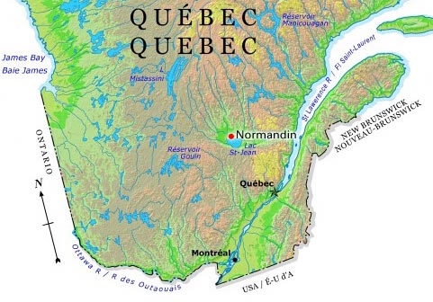
-
Article
D-Day and the Battle of Normandy
The 1944 Battle of Normandy — from the D-Day landings on 6 June through to the encirclement of the German army at Falaise on 21 August — was one of the pivotal events of the Second World War and the scene of some of Canada's greatest feats of arms. Canadian sailors, soldiers and airmen played a critical role in the Allied invasion of Normandy, also called Operation Overlord, beginning the bloody campaign to liberate Western Europe from Nazi occupation. Nearly 150,000 Allied troops landed or parachuted into the invasion area on D-Day, including 14,000 Canadians at Juno Beach. The Royal Canadian Navy contributed 124 vessels and 10,000 sailors and the Royal Canadian Air Force contributed 39 squadrons to the operation. Total Allied casualties on D-Day reached more than 10,000, including 1,096 Canadians, of whom 381 were killed in action. By the end of the Battle of Normandy, the Allies had suffered 209,000 casualties, including more than 18,700 Canadians. Over 5,000 Canadian soldiers died. (This is the full-length entry about D-Day and the Battle of Normandy. For a plain-language summary, please see D-Day and the Battle of Normandy (Plain-Language Summary).)
"https://d3d0lqu00lnqvz.cloudfront.net/media/media/bb05eb99-e533-4e8d-aafe-6ae70bdbf472.jpg" // resources/views/front/categories/view.blade.php
https://d3d0lqu00lnqvz.cloudfront.net/media/media/bb05eb99-e533-4e8d-aafe-6ae70bdbf472.jpg
-
Article
Norse-Indigenous Contact
Norse settlements in southwestern Greenland were the first permanent European settlements in North America. During this time, several Indigenous North American groups lived in nearby regions, such as in High Arctic Greenland and northeastern North America. As a result, Norse and Indigenous people interacted on multiple occasions.
"https://d3d0lqu00lnqvz.cloudfront.net/media/media/8598263f-4e90-4231-a1e2-fe833173962c.jpg" // resources/views/front/categories/view.blade.php
https://d3d0lqu00lnqvz.cloudfront.net/media/media/8598263f-4e90-4231-a1e2-fe833173962c.jpg
-
Article
North
In strictly geographic terms, the North refers to the immense hinterland of Canada that lies beyond the narrow strip of the country in which most Canadians live and work, but generally refers to the Northwest Territories, the Yukon and Nunavut.
"https://d3d0lqu00lnqvz.cloudfront.net/media/media/02e4d1f2-17fa-4305-8972-b3b6b9d152fb.jpg" // resources/views/front/categories/view.blade.php
https://d3d0lqu00lnqvz.cloudfront.net/media/media/02e4d1f2-17fa-4305-8972-b3b6b9d152fb.jpg
-
Article
North Battleford
A new town site, named North Battleford, was laid out in 1905. The community grew rapidly with many businesses and residents abandoning the older community and moving to the new rail centre. By 1913 North Battleford was granted city status.
"https://thecanadianencyclopedia.ca/images/tce_placeholder.jpg?v=e9dca980c9bdb3aa11e832e7ea94f5d9" // resources/views/front/categories/view.blade.php
https://thecanadianencyclopedia.ca/images/tce_placeholder.jpg?v=e9dca980c9bdb3aa11e832e7ea94f5d9
-
Article
North Bay
North Bay, Ontario, incorporated as a city in 1925, population 51,553 (2016 census), 53,651 (2011 census). North Bay is located on a northeastern bay of Lake Nipissing, at the junction of highways 11 and 17, some 345 km north of Toronto and 365 km northwest of Ottawa. As the traditional "Gateway to the North," the city is the administrative seat for the District of Nipissing.
"https://d3d0lqu00lnqvz.cloudfront.net/media/media/feb55fdc-51a1-4214-8a4a-5f5c61e98a6d.jpg" // resources/views/front/categories/view.blade.php
https://d3d0lqu00lnqvz.cloudfront.net/media/media/feb55fdc-51a1-4214-8a4a-5f5c61e98a6d.jpg
-
Article
Music in North Bay
Railway and tourist centre in Ontario situated between Trout Lake and Lake Nipissing, incorporated as a town in 1890 and as a city in 1925, and reaching a population of more than 53,000 by 1990.
"https://thecanadianencyclopedia.ca/images/tce_placeholder.jpg?v=e9dca980c9bdb3aa11e832e7ea94f5d9" // resources/views/front/categories/view.blade.php
https://thecanadianencyclopedia.ca/images/tce_placeholder.jpg?v=e9dca980c9bdb3aa11e832e7ea94f5d9