
Browse "Places"
-
Article
Montreal's Village
The Village is Montreal's gay neighbourhood, centered around Sainte-Catherine Street between Berri and Papineau Streets. It is a vibrant cultural hub, shaped by and for the 2SLGBTQ+ community and a neighbourhood that is constantly reinventing itself. It is the result of decades of resilience in the face of adversity and socio-economic constraints.
"https://d3d0lqu00lnqvz.cloudfront.net/Village-18-nuances-de-gai.jpg" // resources/views/front/categories/view.blade.php
https://d3d0lqu00lnqvz.cloudfront.net/Village-18-nuances-de-gai.jpg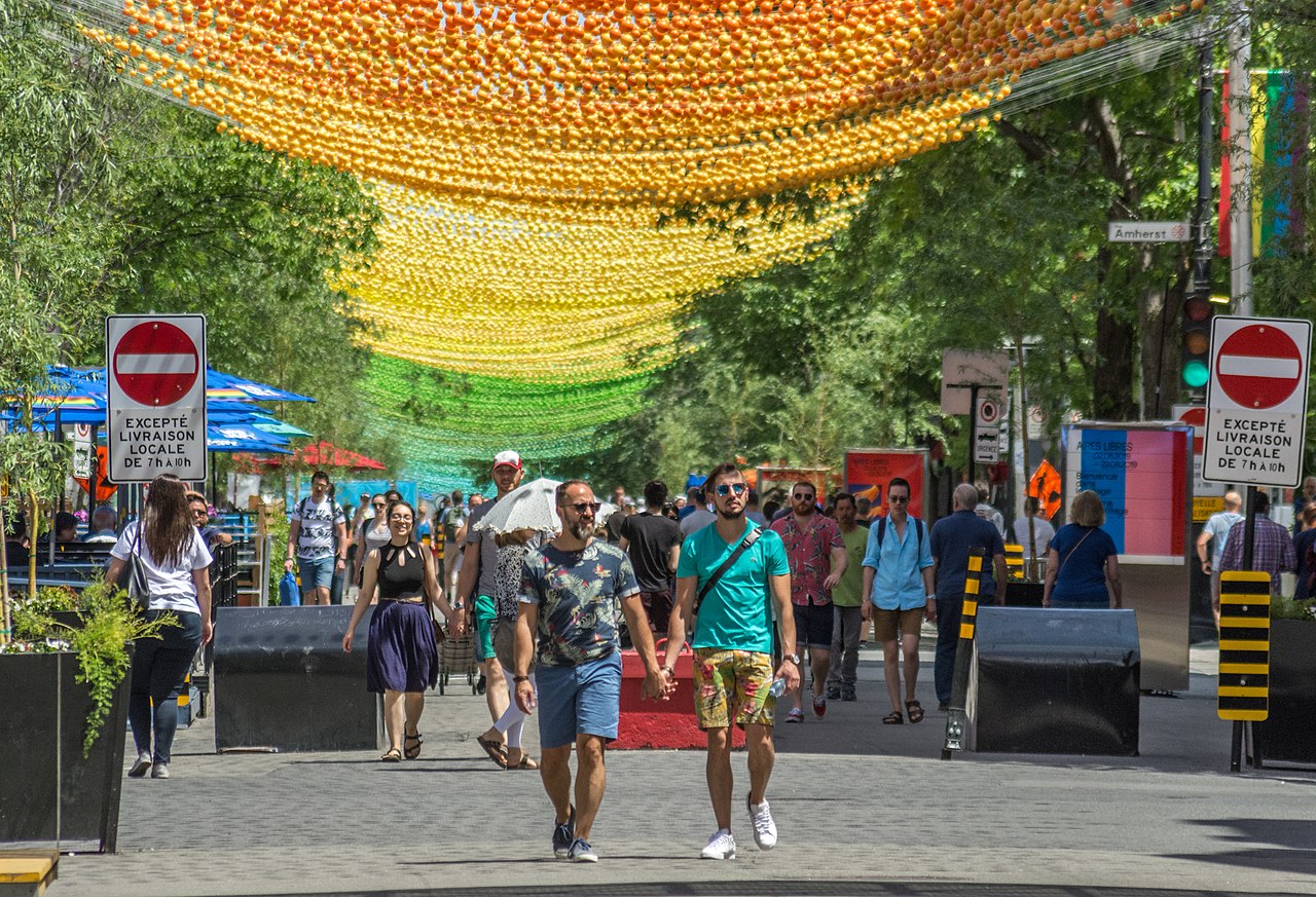
-
Article
Montrose
Montrose, BC, incorporated as a village in 1956, population 1030 (2011c), 1012 (2006c). The Village of Montrose is located in the West Kootenay district of southeastern British Columbia.
"https://thecanadianencyclopedia.ca/images/tce_placeholder.jpg?v=e9dca980c9bdb3aa11e832e7ea94f5d9" // resources/views/front/categories/view.blade.php
https://thecanadianencyclopedia.ca/images/tce_placeholder.jpg?v=e9dca980c9bdb3aa11e832e7ea94f5d9
-
Article
Monts Chic-Chocs
The Monts Chic-Chocs, also known as the Chic-Choc Mountains, are a subrange of mountains located in the Gaspé Peninsula of eastern Quebec. The mountains are very old — hundreds of millions of years old — and heavily eroded. They often have flattened, treeless tops and steep sides, and are well-forested. All ten of the highest peaks in this range are taller than 1,000 m, of which the highest is Mont Jacques-Cartier, named for the explorer who may have been the first European to see the mountains (see Jacques Cartier). The Chic-Chocs are well known for their hiking trails and backcountry skiing. Part of the range lies within the boundaries of a Quebec provincial park and a wildlife preserve. The Chic-Chocs are a unique geographical feature, forming the backbone of the Gaspé Peninsula, and containing within them a complex environment mixing features of eastern woodlands with arctic/subarctic and alpine/subalpine climates. These conditions create a unique landscape as well as the natural environment. The Chic-Chocs are the tallest mountains in southern Quebec.
"https://d3d0lqu00lnqvz.cloudfront.net/montschicchocs/Winterinchicchoc.jpg" // resources/views/front/categories/view.blade.php
https://d3d0lqu00lnqvz.cloudfront.net/montschicchocs/Winterinchicchoc.jpg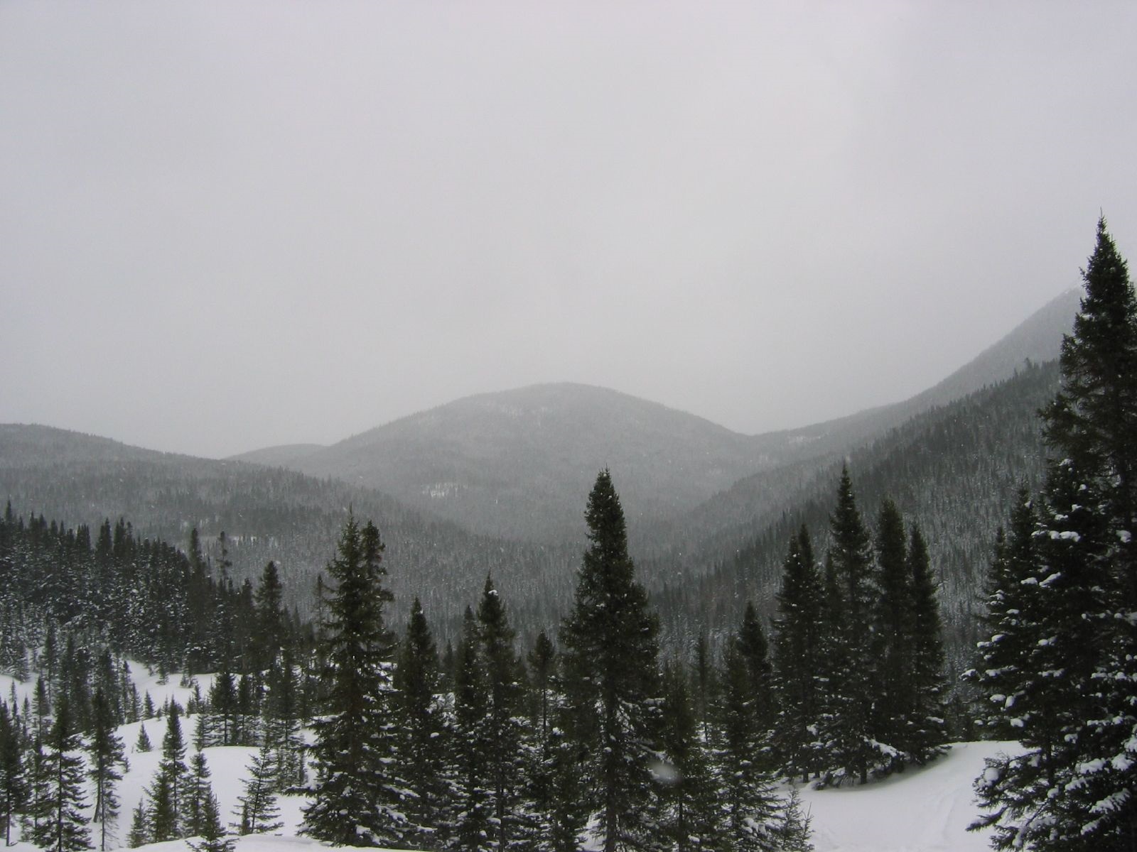
-
Article
Monument
A monument is normally a freestanding, large-scale structure, often artistically embellished, which has as its primary function the commemoration of persons, events or concepts believed to have sufficient importance to merit a public, visible and permanent tribute.
"https://d3d0lqu00lnqvz.cloudfront.net/media/media/dfb21f51-d625-42ea-97e7-a7b4c5b6fb0c.jpg" // resources/views/front/categories/view.blade.php
https://d3d0lqu00lnqvz.cloudfront.net/media/media/dfb21f51-d625-42ea-97e7-a7b4c5b6fb0c.jpg
-
Article
Monument-National
Its 1620-seat theatre, which boasted an orchestra pit, was inaugurated in 1893 while still uncompleted. In the ensuing years it welcomed innumerable solo artists, opera companies, and other musical troupes and ensembles.
"https://d3d0lqu00lnqvz.cloudfront.net/media/media/2f04ca39-ea90-44c3-9c7e-08d4087df26f.jpg" // resources/views/front/categories/view.blade.php
https://d3d0lqu00lnqvz.cloudfront.net/media/media/2f04ca39-ea90-44c3-9c7e-08d4087df26f.jpg
-
Article
Monuments of the First and Second World Wars
Since the end of the First World War, monuments commemorating the lives of Canadians who died in conflicts overseas have occupied a prominent place in our urban cultural landscape. Most were erected in the 1920s and 1930s and represent a commitment never to forget Canadian lives sacrificed in the First World War. The Second World War's claims on Canadian lives reinforced this commitment. In an era when few monuments to contemporary national heroes or great historical events are erected, war monuments retain their capacity to erase time and preserve a memory of those who died for their country.
"https://d3d0lqu00lnqvz.cloudfront.net/media/media/162485bf-95f4-4d5c-a699-2dec659d831e.jpg" // resources/views/front/categories/view.blade.php
https://d3d0lqu00lnqvz.cloudfront.net/media/media/162485bf-95f4-4d5c-a699-2dec659d831e.jpg
-
Article
Moon
The moon is a natural satellite of Earth, with a mean diameter of 3,476 km and a mass of 7.28 x 10²² kg (1.23 per cent of Earth's mass). Three moons of Jupiter and one of Saturn are larger; the dwarf planet Pluto is smaller. The moon's mean distance from Earth is 384,500 km, and its orbit takes 29.5306 days from one New Moon to the next. The moon shines only by reflected sunlight, appearing as a crescent when it is within 90° of the sun. Except near New Moon, it is second only to the sun in brightness. Tidal effects of Earth have forced the moon's rotation to match its orbital period; hence, one side of the moon always faces Earth, and only 59 per cent of its surface is visible. Because it is so close, the moon's influence exceeds the sun's as the cause of tides on Earth. The moon has been important in religion and art since the earliest records of human culture and has served as the basis for the lunar calendar.
"https://d3d0lqu00lnqvz.cloudfront.net/media/media/4bc37824-aa84-4a84-9b3c-b620f26bc350.jpg" // resources/views/front/categories/view.blade.php
https://d3d0lqu00lnqvz.cloudfront.net/media/media/4bc37824-aa84-4a84-9b3c-b620f26bc350.jpg
-
Article
Moose Jaw
Moose Jaw, Saskatchewan, incorporated as a city in 1903, population 33,665 (2021 census), 33,910 (2016 census). The city of Moose Jaw is located 160 km north of the US border and 65 km west of Regina in a sheltered valley at the confluence of the Moose Jaw River and Thunder Creek. It is governed by a mayor and six councillors who are elected to represent the city as a whole. The city’s evocative name is likely based on Indigenous sources and was perhaps first applied to a local creek that supposedly resembled the outline of a moose’s jawbone; another explanation is that it comes from a Cree word for “warm breezes.”
"https://d3d0lqu00lnqvz.cloudfront.net/media/media/d752c9ca-404c-4d3f-906e-cb19fd13e9e6.jpg" // resources/views/front/categories/view.blade.php
https://d3d0lqu00lnqvz.cloudfront.net/media/media/d752c9ca-404c-4d3f-906e-cb19fd13e9e6.jpg
-
Article
Moose River
The Moose River is 547 km long from the head of its tributary, the Mattagami River. It is formed by the confluence of the Mattagami and the Missinaibi rivers, and flows northeast 104 km to discharge into the bottom of James Bay in northern Ontario.
"https://thecanadianencyclopedia.ca/images/tce_placeholder.jpg?v=e9dca980c9bdb3aa11e832e7ea94f5d9" // resources/views/front/categories/view.blade.php
https://thecanadianencyclopedia.ca/images/tce_placeholder.jpg?v=e9dca980c9bdb3aa11e832e7ea94f5d9
-
Article
Moosomin
Moosomin, Saskatchewan, incorporated as a town in 1887, population 2,743 (2016 census), 2,485 (2011 census). The town of Moosomin is located in southeastern Saskatchewan 15 km west of the Manitoba border.
"https://thecanadianencyclopedia.ca/images/tce_placeholder.jpg?v=e9dca980c9bdb3aa11e832e7ea94f5d9" // resources/views/front/categories/view.blade.php
https://thecanadianencyclopedia.ca/images/tce_placeholder.jpg?v=e9dca980c9bdb3aa11e832e7ea94f5d9
-
Article
Moosonee
Moosonee, Ont, incorporated as a town in 2001, population 1725 (2011c), 2006 (2006c). The Town of Moosonee is located on the Moose River, 25 km from James Bay.
"https://thecanadianencyclopedia.ca/images/tce_placeholder.jpg?v=e9dca980c9bdb3aa11e832e7ea94f5d9" // resources/views/front/categories/view.blade.php
https://thecanadianencyclopedia.ca/images/tce_placeholder.jpg?v=e9dca980c9bdb3aa11e832e7ea94f5d9
-
Article
Moraines in Canada
A moraine is a landform composed of an accumulation of sediment deposited by or from a glacier and possessing a form independent of the terrain beneath it. Given its history of glaciations (see Geological History of Canada), Canada is home to numerous moraines.
"https://d3d0lqu00lnqvz.cloudfront.net/lakesincanada/Glacial-Processes.jpg" // resources/views/front/categories/view.blade.php
https://d3d0lqu00lnqvz.cloudfront.net/lakesincanada/Glacial-Processes.jpg
-
Article
Moravian Missions in Labrador
In 1771, Moravian missionaries were the first Europeans to settle in Labrador. Over a 133-year period, they established a series of eight missions along the coast which became the focus of religious, social and economic activities for the Inuit who gradually came to settle near the communities. Moravians had a huge impact on the life and culture of Labrador Inuit. What emerged was a unique culture rooted in Inuit traditions with indigenized European practices. The last Moravian missionary left Labrador in 2005, but the Moravian church, its customs and traditions are still very much alive in Labrador.
"https://d3d0lqu00lnqvz.cloudfront.net/media/new_article_images/MoravianMissionsinCanada/Eine-Schulergrupper-in-Nain-Resized.jpg" // resources/views/front/categories/view.blade.php
https://d3d0lqu00lnqvz.cloudfront.net/media/new_article_images/MoravianMissionsinCanada/Eine-Schulergrupper-in-Nain-Resized.jpg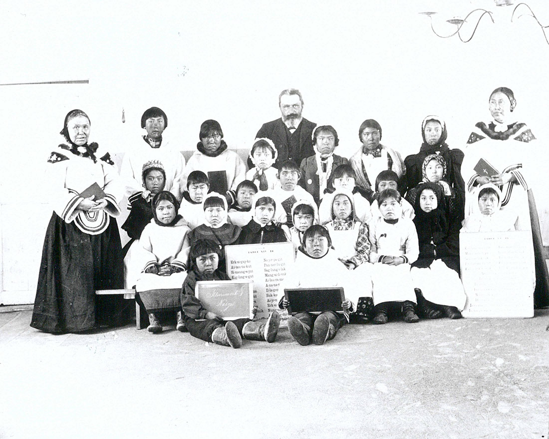
-
Article
Morden
Morden, Manitoba, incorporated as a city in 2012, population 9,929 (2021 census), 8,668 (2016 census). The Town of Morden is located 104 km southwest of Winnipeg and 20 km north of the international boundary with the U.S. Morden is situated in Treaties No. 1 Territory and on the traditional lands of the Anishinaabe, Cree, Oji-Cree, and Dakota Nations. The Métis Nation, notably the Red River Métis, have a historical and ongoing presence on this land.
"https://thecanadianencyclopedia.ca/images/tce_placeholder.jpg?v=e9dca980c9bdb3aa11e832e7ea94f5d9" // resources/views/front/categories/view.blade.php
https://thecanadianencyclopedia.ca/images/tce_placeholder.jpg?v=e9dca980c9bdb3aa11e832e7ea94f5d9
-
Article
Morinville
Morinville, Alta, incorporated as a village in 1901 and as a town in 1911, population 8569 (2011c), 6775 (2006c). The Town of Morinville is located on the Canadian National Railway main line, 41 km northwest of Edmonton.
"https://thecanadianencyclopedia.ca/images/tce_placeholder.jpg?v=e9dca980c9bdb3aa11e832e7ea94f5d9" // resources/views/front/categories/view.blade.php
https://thecanadianencyclopedia.ca/images/tce_placeholder.jpg?v=e9dca980c9bdb3aa11e832e7ea94f5d9