
Browse "Places"
-
Article
Holyrood
Holyrood, NL, incorporated as a town in 1969, population 1995 (2011c), 2005 (2006c). The Town of Holyrood is located at the head of Conception Bay on the Avalon Peninsula about 50 km west of St John's.
"https://thecanadianencyclopedia.ca/images/tce_placeholder.jpg?v=e9dca980c9bdb3aa11e832e7ea94f5d9" // resources/views/front/categories/view.blade.php
https://thecanadianencyclopedia.ca/images/tce_placeholder.jpg?v=e9dca980c9bdb3aa11e832e7ea94f5d9
-
Article
Hoodoo Rock
Hoodoo rocks are often fantastically shaped, naturally carved rocks or earth pedestals, pillars or columns. The term appears to be largely restricted to western North America.
"https://d3d0lqu00lnqvz.cloudfront.net/media/media/251b5d36-82cc-4ec1-80e8-471cfd59098a.jpg" // resources/views/front/categories/view.blade.php
https://d3d0lqu00lnqvz.cloudfront.net/media/media/251b5d36-82cc-4ec1-80e8-471cfd59098a.jpg
-
Article
Hope
Hope, BC, incorporated as a district municipality in 1992, population 5969 (2011c), 6185 (2006c). The District of Hope is located on the Trans-Canada Highway, 150 km east of VANCOUVER where it sits on the east bank of the FRASER RIVER, surrounded on three sides by mountains.
"https://thecanadianencyclopedia.ca/images/tce_placeholder.jpg?v=e9dca980c9bdb3aa11e832e7ea94f5d9" // resources/views/front/categories/view.blade.php
https://thecanadianencyclopedia.ca/images/tce_placeholder.jpg?v=e9dca980c9bdb3aa11e832e7ea94f5d9
-
Article
Hornby Island
Hornby Island lies in the Strait of Georgia between Vancouver Island and mainland British Columbia, southeast of the island community of Courtenay . It is a wooded island with a shoreline of sandbanks and rock shelves.
"https://d3d0lqu00lnqvz.cloudfront.net/media/media/44ecf87e-919b-40ea-8039-8eefd6a41399.jpg" // resources/views/front/categories/view.blade.php
https://d3d0lqu00lnqvz.cloudfront.net/media/media/44ecf87e-919b-40ea-8039-8eefd6a41399.jpg
-
Article
Horton Plain
The vegetation is low arctic tundra in the N, dominated by dwarf shrubs and grasses, and woodland in the S, consisting of scattered, stunted spruce with a lichen carpet. The summer range and calving grounds of the large Bluenose caribou herd lie within this region.
"https://thecanadianencyclopedia.ca/images/tce_placeholder.jpg?v=e9dca980c9bdb3aa11e832e7ea94f5d9" // resources/views/front/categories/view.blade.php
https://thecanadianencyclopedia.ca/images/tce_placeholder.jpg?v=e9dca980c9bdb3aa11e832e7ea94f5d9
-
Article
Horton River
The Horton River, 618 km long, rises north of Great Bear Lake in the Northwest Territories and empties into Amundsen Gulf. Shallowly entrenched in the upper part of its course, it cuts a deep (up to 200 m) valley into the soft Cretaceous bedrock in its lower course.
"https://d3d0lqu00lnqvz.cloudfront.net/media/media/ea3f320f-29ec-47d8-a988-fda2c88fbeda.jpg" // resources/views/front/categories/view.blade.php
https://d3d0lqu00lnqvz.cloudfront.net/media/media/ea3f320f-29ec-47d8-a988-fda2c88fbeda.jpg
-
Article
Hotel
Willard's Hotel (1795) and Cook's Tavern (1822), both in Williamsburg Township, Ont, and now at UPPER CANADA VILLAGE, were stopping places for commercial travellers and immigrants in coaches along the King's Highway and on bateaux on the St Lawrence River.
"https://d3d0lqu00lnqvz.cloudfront.net/media/media/c986ab61-ffd7-4ee5-9c7a-73297719034a.jpg" // resources/views/front/categories/view.blade.php
https://d3d0lqu00lnqvz.cloudfront.net/media/media/c986ab61-ffd7-4ee5-9c7a-73297719034a.jpg
-
Article
House of Commons
The House of Commons is the centre of political power in Canada. The prime minister and his or her Cabinet receive their authority through the confidence of the House. It is an institution steeped in tradition and history. In recent years, Question Period has been televised, opening the political process to Canadians. Much of what the public sees is the rancorous debate and partisan bickering among political parties. But the House of Commons is also where most government legislation is introduced, and where Members of Parliament (MPs) meet to debate policy, vote on key legislation, and hold the government to account.
"https://d3d0lqu00lnqvz.cloudfront.net/media/media/39b78f3a-b1bb-47ec-aa0b-d4f5de005157.jpg" // resources/views/front/categories/view.blade.php
https://d3d0lqu00lnqvz.cloudfront.net/media/media/39b78f3a-b1bb-47ec-aa0b-d4f5de005157.jpg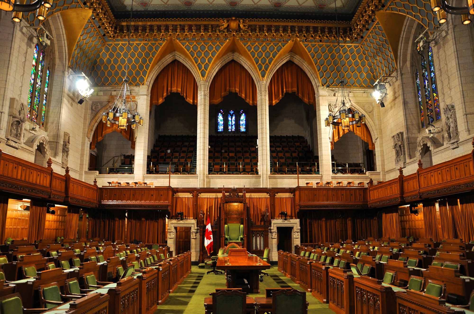
-
Article
Houston
Houston, BC, incorporated as a district municipality in 1969, population 3147 (2011c), 3163 (2006c). The District of Houston is situated midway between PRINCE GEORGE and PRINCE RUPERT on the Yellowhead Highway and at the confluence of the Bulkley and Morice rivers.
"https://thecanadianencyclopedia.ca/images/tce_placeholder.jpg?v=e9dca980c9bdb3aa11e832e7ea94f5d9" // resources/views/front/categories/view.blade.php
https://thecanadianencyclopedia.ca/images/tce_placeholder.jpg?v=e9dca980c9bdb3aa11e832e7ea94f5d9
-
Article
Hudson
This wealthy residential suburb of Montréal is proud of its stately homes, and its residents also highly value a great variety of sports and cultural activities. The town's economy lacks an industrial base.
"https://d3d0lqu00lnqvz.cloudfront.net/media/media/138d11c8-39df-4cf2-9c45-897962add14b.jpg" // resources/views/front/categories/view.blade.php
https://d3d0lqu00lnqvz.cloudfront.net/media/media/138d11c8-39df-4cf2-9c45-897962add14b.jpg
-
Article
Hudson Bay
Hudson Bay is virtually landlocked but is joined to the Arctic Ocean to the north by Foxe Channel and Fury and Hecla Strait, and to the Atlantic Ocean on the east by Hudson Strait. Baffin Island lies athwart the entrance to the bay, and Southampton, Coats and Mansel islands are lodged across the northern gap. The west coast is devoid of islands, but lying off the east is a string known as the Sleepers, Ottawa, Nastapoka and Belcher groups. The maximum length of the bay is 1,500 km and its greatest width 830 km.
"https://d3d0lqu00lnqvz.cloudfront.net/hudsonbay/Hudson_bay_sunset_Canada.jpg" // resources/views/front/categories/view.blade.php
https://d3d0lqu00lnqvz.cloudfront.net/hudsonbay/Hudson_bay_sunset_Canada.jpg
-
Article
Hudson Bay Railway
The idea of the Hudson Bay Railway, which eventually came to run from Winnipeg to The Pas, and then to Churchill, Manitoba, was conceived by public and private interests in the late 19th century as a means of transporting grain as quickly as possible onto ships for overseas sale. Over a period of almost 50 years, construction efforts ran into various problems — including engineering disputes, storms, a harsh northern climate, fires, labour unrest, and material and labour shortages. From 1910 onwards, the federal government took charge of paying for the engineering and construction work for the railway line, particularly after the creation of Canadian National Railways in 1919. The line was completed in 1929 and opened for full service in 1931. (See also Railway History in Canada.)
"https://d3d0lqu00lnqvz.cloudfront.net/hudsonbayrailway/engine2735.jpg" // resources/views/front/categories/view.blade.php
https://d3d0lqu00lnqvz.cloudfront.net/hudsonbayrailway/engine2735.jpg
-
Article
Hudson Bay (Sask)
By the end of WWII the community had grown sufficiently to obtain town status, a fact emphasized by dropping "Junction" from its name (1947). Since then, while growth has continued, the economy has been modified.
"https://thecanadianencyclopedia.ca/images/tce_placeholder.jpg?v=e9dca980c9bdb3aa11e832e7ea94f5d9" // resources/views/front/categories/view.blade.php
https://thecanadianencyclopedia.ca/images/tce_placeholder.jpg?v=e9dca980c9bdb3aa11e832e7ea94f5d9
-
Article
Hudson Strait
Hudson Strait is an arm of the sea connecting the Atlantic Ocean with Hudson Bay and Foxe Channel and separating Baffin Island from the Ungava Peninsula of Québec. The eastern gap is between Cape Chidley, at the northern tip of Labrador, and Resolution Island.
"https://thecanadianencyclopedia.ca/images/tce_placeholder.jpg?v=e9dca980c9bdb3aa11e832e7ea94f5d9" // resources/views/front/categories/view.blade.php
https://thecanadianencyclopedia.ca/images/tce_placeholder.jpg?v=e9dca980c9bdb3aa11e832e7ea94f5d9
-
Article
Hull
Hull, Quebec, is part of the city of Gatineau. Originally its own municipality, Hull amalgamated with the municipalities of Aylmer, Buckingham, Gatineau and Masson-Angers in 2002. When Hull was incorporated in 1875, it was named after the township in which it was situated. In turn, Hull Township got its name from the city of Hull in Yorkshire, England.
"https://d3d0lqu00lnqvz.cloudfront.net/media/media/803bc157-04ec-48c6-8f84-23149e23faad.jpg" // resources/views/front/categories/view.blade.php
https://d3d0lqu00lnqvz.cloudfront.net/media/media/803bc157-04ec-48c6-8f84-23149e23faad.jpg