Browse "Places"
-
Article
Geography of New Brunswick
New Brunswick is part of the Appalachian region, one of Canada’s seven physiographic regions. The province’s principal geographic divisions are the watershed of the Bay of Fundy, centering on the Saint John River valley, and the north and east shores. The residents of the north and east shores live in coastal fishing villages and interior lumbering settlements along rivers. They are separated physically from the valley communities by uplands and belts of forest. They are also separated culturally by their predominantly French language and Catholic religion.
"https://d3d0lqu00lnqvz.cloudfront.net/media/media/06045521-0423-40e4-bb35-b6789d7556cf.jpg" // resources/views/front/categories/view.blade.php
https://d3d0lqu00lnqvz.cloudfront.net/media/media/06045521-0423-40e4-bb35-b6789d7556cf.jpg
-
Article
Geography of Newfoundland and Labrador
Newfoundland and Labrador is divided by three of Canada’s seven physiographic regions. These three regions are the Canadian Shield in Labrador, and the Appalachian and Eastern St. Lawrence Lowlands on the island of Newfoundland. Labrador’s northern coastal region is mountainous, deeply fjorded, and grows only ground-level, subarctic vegetation. Its southern coast has a rugged, barren foreshore and a forested hinterland. The interior of Labrador is a well-forested, dissected plateau. Most of Labrador’s most-populous towns, including Happy-Valley Goose Bay and Labrador City, are located in its interior. On the island of Newfoundland the west coast is dominated by the table-topped Long Range Mountains. The northeast coast, with its numerous bays, islands and headlands, fronts on the Atlantic Ocean from the Great Northern Peninsula to the Avalon Peninsula. Newfoundland’s southern coast has the deeply embayed characteristics of a submerged shoreline. The inland areas of the island are generally hilly and rugged. Shallow bogs and heath vegetation covers much of the land. Most of Newfoundland’s towns and cities are located in the bays and coves of the island’s west and northeast coasts.
"https://d3d0lqu00lnqvz.cloudfront.net/media/new_article_images/GeographyofNFLD/ChurchillFalls.jpg" // resources/views/front/categories/view.blade.php
https://d3d0lqu00lnqvz.cloudfront.net/media/new_article_images/GeographyofNFLD/ChurchillFalls.jpg
-
Article
Geography of Nova Scotia
Nova Scotia is part of the Appalachian region, one of Canada seven physiographic regions. The province is primarily a peninsula extending from the country’s mainland. At its northeastern end is Cape Breton Island. Surrounded by the Atlantic Ocean, Nova Scotia is separated from Prince Edward Island by the Northumberland Strait and from New Brunswick by the Bay of Fundy.
"https://d3d0lqu00lnqvz.cloudfront.net/media/media/276c48ba-ecfb-4c4a-aec6-e7bba279abf9.jpg" // resources/views/front/categories/view.blade.php
https://d3d0lqu00lnqvz.cloudfront.net/media/media/276c48ba-ecfb-4c4a-aec6-e7bba279abf9.jpg
-
Article
Geography of Nunavut
Nunavut covers 1,936,113 km2 of land and 157,077 km2 of water in Northern Canada, representing 21 per cent of the country’s total area. The territory includes part of the mainland, most of the Arctic Archipelago, and all of the islands in Hudson Bay, James Bay and Ungava Bay. Nunavut is divided by three of Canada’s seven physiographic regions. These regions are the Hudson Bay Lowlands, the Canadian Shield and the Canadian Arctic.
"https://d3d0lqu00lnqvz.cloudfront.net/media/media/49bea33f-0f3c-4b4c-b687-c347c4e03047.jpg" // resources/views/front/categories/view.blade.php
https://d3d0lqu00lnqvz.cloudfront.net/media/media/49bea33f-0f3c-4b4c-b687-c347c4e03047.jpg
-
Article
Geography of Ontario
Ontario is divided by three of Canada’s seven physiographic regions. These three regions are the Hudson Bay Lowlands, the Canadian Shield and the St. Lawrence Lowlands. Agriculture, as well as most of the population, is concentrated in the south. Despite the tendency to divide the province into three regions, there are distinct areas within these broad classifications. Geology, climate, soil and vegetation combine to create these distinct areas.
"https://d3d0lqu00lnqvz.cloudfront.net/media/media/d843f78b-9289-43dc-8791-10b06a322b23.jpg" // resources/views/front/categories/view.blade.php
https://d3d0lqu00lnqvz.cloudfront.net/media/media/d843f78b-9289-43dc-8791-10b06a322b23.jpg
-
Article
Geography of Prince Edward Island
Prince Edward Island is part of the Appalachian region, one of Canada’s seven physiographic regions. The island extends for 224 km, with a width ranging from 4 to 60 km. It is known for its reddish-brown soil, so-coloured due to high concentrations of iron oxides.
"https://d3d0lqu00lnqvz.cloudfront.net/media/new_article_images/GeographyofPEI/RedSoil.jpg" // resources/views/front/categories/view.blade.php
https://d3d0lqu00lnqvz.cloudfront.net/media/new_article_images/GeographyofPEI/RedSoil.jpg
-
Article
Geography of Quebec
The province of Quebec is composed of three of Canada’s seven physiographic regions. These regions are the St. Lawrence Lowlands, the Canadian Shield and the Appalachian region. The St. Lawrence Lowlands is the most fertile and developed region. The majority of the population of Quebec lives here, mainly between Montreal and Quebec City. The Canadian Shield covers most of Quebec from approximately 80 km north of the St. Lawrence River valley up to the Ungava region. It is a vast region composed of thousands of lakes and thousands of square kilometres of forested area. On the south bank of the St. Lawrence River, between the Richelieu River and the Gaspé Peninsula, is the Quebec part of the Appalachian mountain chain which extends from Gaspé south to Alabama.
"https://d3d0lqu00lnqvz.cloudfront.net/media/media/4ebdf498-3fb2-49b3-8f2d-8dc8efc3a7a0.jpg" // resources/views/front/categories/view.blade.php
https://d3d0lqu00lnqvz.cloudfront.net/media/media/4ebdf498-3fb2-49b3-8f2d-8dc8efc3a7a0.jpg
-
Article
Geography of Saskatchewan
Saskatchewan is divided by two of Canada’s seven physiographic regions. These two regions are the Interior Plains and the Canadian Shield. The Canadian Shield is characterized by rugged rock exposures and many lakes. It also includes a sandy region south of Lake Athabasca. South of the Canadian Shield is the area commonly called the “grain belt.” It is characterized by level or gently rolling plains and fertile soils. Saskatchewan is known as one of the world’s great wheat producers. On the western boundary and across the southwest corner is another plains region of generally higher altitudes. Its rolling and hilly terrain is distinct from that of the grain belt. The extreme southwest the province shares the Cypress Hills with Alberta. The Cypress Hills are the highest point of land in Canada between the Rocky Mountains and Labrador.
"https://d3d0lqu00lnqvz.cloudfront.net/media/new_article_images/GeographyofSaskatchewan/5459781967_6d2399bcb6_c.jpg" // resources/views/front/categories/view.blade.php
https://d3d0lqu00lnqvz.cloudfront.net/media/new_article_images/GeographyofSaskatchewan/5459781967_6d2399bcb6_c.jpg
-
Article
Geography of the Northwest Territories
The Northwest Territories includes three main geographic regions: the Arctic Archipelago to the north, the arctic mainland and the Mackenzie Valley area. The arctic mainland, sometimes referred to as the Barren Lands, lies northeast of the treeline, and the Mackenzie Valley area to the west. The geography of the Northwest Territories may also be thought of in terms of Canada’s seven physiographic regions. The territories include four of these regions, namely the Western Cordillera, the Interior Plains, the Canadian Shield and the Canadian Arctic.
"https://d3d0lqu00lnqvz.cloudfront.net/media/new_article_images/GeographyofNWT/GreatSlaveLake.jpg" // resources/views/front/categories/view.blade.php
https://d3d0lqu00lnqvz.cloudfront.net/media/new_article_images/GeographyofNWT/GreatSlaveLake.jpg
-
Article
Geography of Yukon
The Yukon is divided by three of Canada’s seven physiographic regions. The vast majority of the territory is within the Western Cordillera region, while small, northern portions belong to the Canadian Arctic and Interior Plains. Geographically the bulk of the Yukon is a subarctic plateau interspersed by mountains. The major exception is the Arctic Coastal Plain, a narrower eastward continuation of the same region in Alaska, which slopes down to the Beaufort Sea from the British Mountains inland.
"https://d3d0lqu00lnqvz.cloudfront.net/media/new_article_images/GeographyofYukon/Mountains.jpg" // resources/views/front/categories/view.blade.php
https://d3d0lqu00lnqvz.cloudfront.net/media/new_article_images/GeographyofYukon/Mountains.jpg
-
Article
Geological Regions (Plain-Language Summary)
Geology is the study of what the Earth is made of and how it has changed over time. There are six geological regions in Canada. These regions are the Canadian Shield, the Interior Platform, the Appalachian Orogen, the Innuitian Orogen, the Cordillera and Western Canada Sedimentary Basin, and the Eastern Continental Margin. This article is a plain-language summary of the geological regions of Canada. If you are interested in reading about this topic in more depth, please see the full-length entry, Geological Regions.
"https://d3d0lqu00lnqvz.cloudfront.net/media/media/e6e2df67-a33a-46cb-ab6d-dc659323ec1d.jpg" // resources/views/front/categories/view.blade.php
https://d3d0lqu00lnqvz.cloudfront.net/media/media/e6e2df67-a33a-46cb-ab6d-dc659323ec1d.jpg
-
Article
George River
George River, 560 km long, in northern Québec, drains N into the E side of Ungava Bay. Its southern and eastern divides, along with those of tributary rivers Ford and De Pas, extend along much of the Québec-Newfoundland and Labrador border.
"https://thecanadianencyclopedia.ca/images/tce_placeholder.jpg?v=e9dca980c9bdb3aa11e832e7ea94f5d9" // resources/views/front/categories/view.blade.php
https://thecanadianencyclopedia.ca/images/tce_placeholder.jpg?v=e9dca980c9bdb3aa11e832e7ea94f5d9
-
Article
Georges Bank
Georges Bank is a large submarine bank (250 km by 150 km) at the edge of the Atlantic continental shelf between Cape Cod and Nova Scotia. Typical water depths are 50-80 m, but in some areas the water shoals to 10 m and less.
"https://d3d0lqu00lnqvz.cloudfront.net/media/media/1e88d9f5-39be-4e62-9ef7-b8f4444e4965.jpg" // resources/views/front/categories/view.blade.php
https://d3d0lqu00lnqvz.cloudfront.net/media/media/1e88d9f5-39be-4e62-9ef7-b8f4444e4965.jpg
-
Article
George's Jazz Room
George's Jazz Room (George's Spaghetti House, 1956-84). Restaurant, the longest-running jazz club in Canada.
"https://thecanadianencyclopedia.ca/images/tce_placeholder.jpg?v=e9dca980c9bdb3aa11e832e7ea94f5d9" // resources/views/front/categories/view.blade.php
https://thecanadianencyclopedia.ca/images/tce_placeholder.jpg?v=e9dca980c9bdb3aa11e832e7ea94f5d9
-
Article
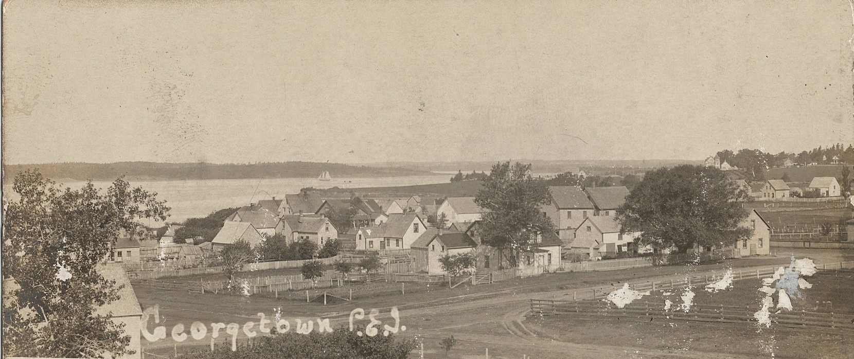
Georgetown
Georgetown, Prince Edward Island, incorporated as a town in 1912, population 351 (2021 census), 372 (2016 census). Georgetown is a community within the municipality of Three Rivers. Three Rivers formed in 2018 when Georgetown amalgamated with the town of Montague, the rural municipalities of Brudenell, Cardigan, Lorne Valley, Lower Montague, Valleyfield and 18 other rural areas. Georgetown is the capital of Kings County and is located at the eastern end of PEI on an 8 km-long peninsula.
"https://d3d0lqu00lnqvz.cloudfront.net/georgetown/georgetown.jpg" // resources/views/front/categories/view.blade.php
https://d3d0lqu00lnqvz.cloudfront.net/georgetown/georgetown.jpg