
Browse "Places"
-
Article
Orford Arts Centre/Centre d'arts Orford
Orford Arts Centre/Centre d'arts Orford (JMC Music Camp 1951-67; JMC Orford Art(s) Centre 1967-86). Summer music camp and cultural centre established in 1951 by the Jeunesses musicales of Canada (Youth and Music Canada) in Mount Orford Provincial Park near Magog, 112 km from Montreal. Covering 88.
"https://thecanadianencyclopedia.ca/images/tce_placeholder.jpg?v=e9dca980c9bdb3aa11e832e7ea94f5d9" // resources/views/front/categories/view.blade.php
https://thecanadianencyclopedia.ca/images/tce_placeholder.jpg?v=e9dca980c9bdb3aa11e832e7ea94f5d9
-
Article
Orillia
Orillia, Ontario, incorporated as a village in 1867, as a town in 1875 and as a city in 1969, population 33,411 (2021 census), 31,166 (2016 census). The city of Orillia is located on the shores of Lakes Simcoe and Couchiching in central Ontario. The name likely derives from the Spanish word for the bank of a river or shore of a lake, orilla. The name was given by Sir Peregrine Maitland, lieutenant-governor of Upper Canada (1818-28), who had served in Spain.
"https://thecanadianencyclopedia.ca/images/tce_placeholder.jpg?v=e9dca980c9bdb3aa11e832e7ea94f5d9" // resources/views/front/categories/view.blade.php
https://thecanadianencyclopedia.ca/images/tce_placeholder.jpg?v=e9dca980c9bdb3aa11e832e7ea94f5d9
-
Article
Orkney
Since 1926 the Rural Municipality of Orkney has had a joint administration with the neighbouring rural municipality of Wallace. There are 2 communities in the rural municipality, Orcadia, a stop on the Canadian Pacific Railway line and White Spruce.
"https://d3d0lqu00lnqvz.cloudfront.net/media/media/70457afb-6f7d-4316-b6b4-db43541c3e08.jpg" // resources/views/front/categories/view.blade.php
https://d3d0lqu00lnqvz.cloudfront.net/media/media/70457afb-6f7d-4316-b6b4-db43541c3e08.jpg
-
Article
Oromocto
Oromocto, New Brunswick, incorporated as a town in 1956, population 9,045 (2021 census), 9,223 (2016 census). The town of Oromocto is located at the junction of the Oromocto and Saint John rivers, 22 km southeast of Fredericton. The Wolastoqiyik (Maliseet) called the Oromocto River Wel-a-mook'-took (“deep water”) because of its good canoeing. The northeastern portion of the town bounds the Oromocto First Nation’s reserve, Oromocto No. 26.
"https://thecanadianencyclopedia.ca/images/tce_placeholder.jpg?v=e9dca980c9bdb3aa11e832e7ea94f5d9" // resources/views/front/categories/view.blade.php
https://thecanadianencyclopedia.ca/images/tce_placeholder.jpg?v=e9dca980c9bdb3aa11e832e7ea94f5d9
-
Article
Orpheum Theatre (Vancouver)
Opened in 1927 as a movie theatre palace and vaudeville house, Vancouver’s Orpheum Theatre was for many years Canada's largest and most opulent theatre. A much-loved concert space and architectural gem, the 2,688-seat venue located at 884 Granville Street was revitalized in the mid-1970s and recognized as a National Historic Site in 1979. Operated by Vancouver Civic Theatres, it remains one of Canada's premier concert halls and presents a wide variety of classical and contemporary performances. It is the permanent home of the Vancouver Symphony Orchestra (VSO) and has been the main venue for the Vancouver Bach Choir, the Vancouver Cantata Singers, the Vancouver Chamber Choir and the Vancouver Recital Society.
"https://d3d0lqu00lnqvz.cloudfront.net/media/media/025832f7-751c-4383-b71e-301b8ad133d8.jpg" // resources/views/front/categories/view.blade.php
https://d3d0lqu00lnqvz.cloudfront.net/media/media/025832f7-751c-4383-b71e-301b8ad133d8.jpg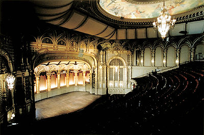
-
Article
Orpheum Theatre
Designed by architect Benjamin Marcus Priteca in "conservative Spanish Renaissance" style and financed by Vancouver businessman Joseph Langer, the Orpheum Theatre was for many years Canada's largest and most opulent theatre.
"https://d3d0lqu00lnqvz.cloudfront.net/media/media/025832f7-751c-4383-b71e-301b8ad133d8.jpg" // resources/views/front/categories/view.blade.php
https://d3d0lqu00lnqvz.cloudfront.net/media/media/025832f7-751c-4383-b71e-301b8ad133d8.jpg
-
Article
Orpheum Theatre (Montréal)
The Orpheum Theatre/Théâtre Orpheum was an 1,100-seat auditorium located at 525 Sainte-Catharine Street West in Montréal.
"https://thecanadianencyclopedia.ca/images/tce_placeholder.jpg?v=e9dca980c9bdb3aa11e832e7ea94f5d9" // resources/views/front/categories/view.blade.php
https://thecanadianencyclopedia.ca/images/tce_placeholder.jpg?v=e9dca980c9bdb3aa11e832e7ea94f5d9
-
Article
Oshawa
Oshawa, ON, incorporated as a city in 1924, population 159,458 (2016 census), 149,607 (2011 census). The city of Oshawa is located 52 km east of Toronto on Lake Ontario. Originally called Skae's Corners, its present name is an Ojibwa term meaning “that point at the crossing of the stream where the canoe was exchanged for the trail.” In 1974, Oshawa became part of the newly formed Regional Municipality of Durham.
"https://thecanadianencyclopedia.ca/images/tce_placeholder.jpg?v=e9dca980c9bdb3aa11e832e7ea94f5d9" // resources/views/front/categories/view.blade.php
https://thecanadianencyclopedia.ca/images/tce_placeholder.jpg?v=e9dca980c9bdb3aa11e832e7ea94f5d9
-
Article
Music in Oshawa
City incorporated in 1924 and located on Lake Ontario, 53 km east of Toronto. In 1778 the first settlers in the area, United Empire Loyalists, were given Crown land. In 1850 the community was declared a village, and the name Oshawa was adopted.
"https://thecanadianencyclopedia.ca/images/tce_placeholder.jpg?v=e9dca980c9bdb3aa11e832e7ea94f5d9" // resources/views/front/categories/view.blade.php
https://thecanadianencyclopedia.ca/images/tce_placeholder.jpg?v=e9dca980c9bdb3aa11e832e7ea94f5d9
-
Article
Osoyoos
Osoyoos, BC, incorporated as a town in 1946, population 4845 (2011c), 4752 (2006c). The Town of Osoyoos is located on Osoyoos Lake, 60 km south of Penticton in the OKANAGAN VALLEY.
"https://thecanadianencyclopedia.ca/images/tce_placeholder.jpg?v=e9dca980c9bdb3aa11e832e7ea94f5d9" // resources/views/front/categories/view.blade.php
https://thecanadianencyclopedia.ca/images/tce_placeholder.jpg?v=e9dca980c9bdb3aa11e832e7ea94f5d9
-
Article
Ottawa
Ottawa, Ontario, incorporated as a city in 1855, population 1,017,449 (2021 census), 934,243 (2016 census). The City of Ottawa is the capital of Canada and is located on the Ottawa River on Ontario's eastern boundary with Québec, about 200 km west of Montréal. The name "Ottawa" is thought to derive from an Algonquian-speaking First Nation of the same name, probably from a word meaning "to trade" (see Odawa). Amalgamation, on 1 January 2001, merged "old" Ottawa with 11 area municipalities and the Regional Municipality of Ottawa-Carleton to create a “new” city. The amalgamated city encompasses the municipalities of Ottawa, Vanier, Nepean, Kanata, Gloucester and Cumberland; the townships of Rideau, West Carleton, Goulbourn and Osgoode; and the village of Rockcliffe Park.
"https://d3d0lqu00lnqvz.cloudfront.net/media/media/604a383c-e913-458a-b6b2-759c08afa1f6.jpg" // resources/views/front/categories/view.blade.php
https://d3d0lqu00lnqvz.cloudfront.net/media/media/604a383c-e913-458a-b6b2-759c08afa1f6.jpg
-
Article
Music in Ottawa
Canada's capital city, situated in Ontario on the Ottawa River. Settled in the early 1800s, it was called Bellows' Landing (1810), Richmond Landing (1811), and Bytown (1826) after Col John By, who, 1826-32, supervised the building of the Rideau Canal.
"https://thecanadianencyclopedia.ca/images/tce_placeholder.jpg?v=e9dca980c9bdb3aa11e832e7ea94f5d9" // resources/views/front/categories/view.blade.php
https://thecanadianencyclopedia.ca/images/tce_placeholder.jpg?v=e9dca980c9bdb3aa11e832e7ea94f5d9
-
Article
Ottawa River
The Ottawa River is Canada’s eighth largest river and the chief tributary of the St. Lawrence. Beginning in the Laurentian Mountains, it flows west before turning southeast to form a portion of the border between Ontario and Quebec. It drains an area twice the size of New Brunswick. As the traditional territory of the Algonquin people, a key route in the fur trade and the site of a 19th-century timber boom, the Ottawa River has played an important role in Canada’s history and economy. Its diverse ecosystems, which are currently the focus of several conservation efforts, are home to rich plant and animal life. The river also sustains urban areas along its shores, the largest being the Ottawa-Gatineau area.
"https://d3d0lqu00lnqvz.cloudfront.net/media/media/825e159e-138b-4954-8dcb-5d6f9dc64f37.jpg" // resources/views/front/categories/view.blade.php
https://d3d0lqu00lnqvz.cloudfront.net/media/media/825e159e-138b-4954-8dcb-5d6f9dc64f37.jpg
-
Article
Otterburn Park
The name Otterburn is a reminder of the birthplace of Sir Joseph Hickson, general manager of the GRAND TRUNK RAILWAY from 1874 to 1890.
"https://d3d0lqu00lnqvz.cloudfront.net/media/media/3343e517-5699-4e5b-8d48-17cc5952b771.jpg" // resources/views/front/categories/view.blade.php
https://d3d0lqu00lnqvz.cloudfront.net/media/media/3343e517-5699-4e5b-8d48-17cc5952b771.jpg
-
Article
Ouimet Canyon Provincial Park
A spectacular, steep-sided gorge cut into volcanic rock of Lake Superior's northern shore is protected in Ouimet Canyon Provincial Park (established 1972, 777 ha), 65 km northeast of Thunder Bay, Ontario.
"https://d3d0lqu00lnqvz.cloudfront.net/media/media/fe2420b7-d26b-483e-b339-46a75ac65e13.jpg" // resources/views/front/categories/view.blade.php
https://d3d0lqu00lnqvz.cloudfront.net/media/media/fe2420b7-d26b-483e-b339-46a75ac65e13.jpg