Browse "Geographical Features"
-
Article
Lake Erie
Lake Erie, 25,700 km2 (including islands), of which 12,800 km2 lie in Canada, elevation 173.3 m; 388 km long, 92 km wide and 64 m deep. The shallowest of the five major Great Lakes (excluding Lake St. Clair), it receives most of its waters from Lake Huron via the Detroit River. Other major inflowing streams are the Maumee and Cuyahoga rivers in Ohio, and the Grand River in Ontario. The lake outflows through the Niagara River at Fort Erie, falling almost 100 m to Lake Ontario; more than 50 m of this drop occurs at Niagara Falls. It is also joined to Lake Ontario by the Welland Canal. (See also Largest Lakes in Canada.)
"https://d3d0lqu00lnqvz.cloudfront.net/pointpelee/Southern-Point.jpg" // resources/views/front/categories/view.blade.php
https://d3d0lqu00lnqvz.cloudfront.net/pointpelee/Southern-Point.jpg
-
Article
Esker
An esker is a ridge (Gaelic eiscir, "ridge") of gravel and sand emplaced during glacial melt by the deposition of sediments from meltwater rivers flowing on the ice (channel fills) or beneath a glacier (tunnel fills).
"https://thecanadianencyclopedia.ca/images/tce_placeholder.jpg?v=e9dca980c9bdb3aa11e832e7ea94f5d9" // resources/views/front/categories/view.blade.php
https://thecanadianencyclopedia.ca/images/tce_placeholder.jpg?v=e9dca980c9bdb3aa11e832e7ea94f5d9
-
Article
Husky Lakes
Husky Lakes, 880 km2, lie along the southern edge of the Tuktoyaktuk Peninsula, NWT, and drain into Liverpool Bay on the Beaufort Sea. Though commonly known as Husky Lakes, the name “Eskimo Lakes” still appears in certain maps and literature. (See also Eskimo.)
"https://thecanadianencyclopedia.ca/images/tce_placeholder.jpg?v=e9dca980c9bdb3aa11e832e7ea94f5d9" // resources/views/front/categories/view.blade.php
https://thecanadianencyclopedia.ca/images/tce_placeholder.jpg?v=e9dca980c9bdb3aa11e832e7ea94f5d9
-
Article
Exploits River
The Exploits River, 246 km long is the longest river on the Island of Newfoundland. Its tributaries, the Lloyds and Victoria rivers, rise in the southwest corner of the Island and flow northeast into Red Indian Lake (250 km2).
"https://thecanadianencyclopedia.ca/images/tce_placeholder.jpg?v=e9dca980c9bdb3aa11e832e7ea94f5d9" // resources/views/front/categories/view.blade.php
https://thecanadianencyclopedia.ca/images/tce_placeholder.jpg?v=e9dca980c9bdb3aa11e832e7ea94f5d9
-
Article
Fairweather Mountain
Fairweather Mountain, elevation 4663 m, is located at the southern end of the St Elias Range, on the BC-Alaska border, where a segment of the BC border juts southwest, nearly cutting off the Alaska Panhandle.
"https://thecanadianencyclopedia.ca/images/tce_placeholder.jpg?v=e9dca980c9bdb3aa11e832e7ea94f5d9" // resources/views/front/categories/view.blade.php
https://thecanadianencyclopedia.ca/images/tce_placeholder.jpg?v=e9dca980c9bdb3aa11e832e7ea94f5d9
-
Article
Fishing Islands
Fishing Islands, an archipelago of about 15 islets in Lake Huron (scattered in an area of 10 km2), lie off the west coast of the Bruce Peninsula in western Ontario between Chiefs Point and Pike Bay.
"https://thecanadianencyclopedia.ca/images/tce_placeholder.jpg?v=e9dca980c9bdb3aa11e832e7ea94f5d9" // resources/views/front/categories/view.blade.php
https://thecanadianencyclopedia.ca/images/tce_placeholder.jpg?v=e9dca980c9bdb3aa11e832e7ea94f5d9
-
Article
Fjord
In oceanographic terminology, fjords are estuaries, ie, semienclosed bodies of water in which seawater is measurably diluted by fresh water from land drainage.
"https://d3d0lqu00lnqvz.cloudfront.net/media/media/c86e45b6-5998-4dec-b556-28266c7e0f25.jpg" // resources/views/front/categories/view.blade.php
https://d3d0lqu00lnqvz.cloudfront.net/media/media/c86e45b6-5998-4dec-b556-28266c7e0f25.jpg
-
Article
Saguenay River Fjord
The Saguenay Fjord was carved out near the very edge of the North American continental ice sheet. This fjord has the very rare characteristic of being intracontinental. Most other fjords, such as those on Baffin Island and in British Columbia, Scandinavia, and Chile, empty directly into the ocean. But the Saguenay Fjord lies in the interior of North America, providing a water passage into the Laurentian Highlands from which Hudson Bay can be reached by an inland route with which Indigenous people were familiar long before Europeans arrived. Tadoussac, at the mouth of the fjord, became the first trading post in Canada in 1599, because Indigenous tribes were already accustomed to meeting at this location to trade with one another.
"https://d3d0lqu00lnqvz.cloudfront.net/media/media/a55e173a-8fe1-4632-be7f-30e85bb60caf.jpg" // resources/views/front/categories/view.blade.php
https://d3d0lqu00lnqvz.cloudfront.net/media/media/a55e173a-8fe1-4632-be7f-30e85bb60caf.jpg
-
Article
Fogo Island
Fogo Island, Nfld, 254 km2, 15 km off Newfoundland's north-east coast, was named y do fogo, "fire island", by the Portuguese. The irregularly shaped island, heavily forested in the south, lies on shallow Fogo Shelf, which attracts salmon, cod and other species.
"https://thecanadianencyclopedia.ca/images/tce_placeholder.jpg?v=e9dca980c9bdb3aa11e832e7ea94f5d9" // resources/views/front/categories/view.blade.php
https://thecanadianencyclopedia.ca/images/tce_placeholder.jpg?v=e9dca980c9bdb3aa11e832e7ea94f5d9
-
Article
Foothills
Foothills, a region of rolling, undulating or hilly terrain lying between an area of plains and a mountain range.
"https://d3d0lqu00lnqvz.cloudfront.net/media/media/1a15198f-4119-4d42-b163-cac45bab0ac1.jpg" // resources/views/front/categories/view.blade.php
https://d3d0lqu00lnqvz.cloudfront.net/media/media/1a15198f-4119-4d42-b163-cac45bab0ac1.jpg
-
Article
Forest
A forest is an ecosystem characterized by a dense and extensive tree cover. It includes not only trees but also shrubs, vines, herbs, mosses, microorganisms, insects, and vertebrate animals that interact with each other and with their environment. This complex pattern of life is a system in delicate balance. Natural or human-caused alterations may trigger far-reaching and sometimes disastrous changes.
"https://d3d0lqu00lnqvz.cloudfront.net/forest/Spruce-Forest-in-Winter.jpg" // resources/views/front/categories/view.blade.php
https://d3d0lqu00lnqvz.cloudfront.net/forest/Spruce-Forest-in-Winter.jpg
-
Article
Fosheim Peninsula
The Fosheim Peninsula is located on the west coast of central Ellesmere Island, Nunavut.
"https://d3d0lqu00lnqvz.cloudfront.net/media/media/99c8f8a7-e4a8-4cab-85df-fa919f71879c.JPG" // resources/views/front/categories/view.blade.php
https://d3d0lqu00lnqvz.cloudfront.net/media/media/99c8f8a7-e4a8-4cab-85df-fa919f71879c.JPG
-
Article
Foxe Basin
Foxe Basin is bordered on its eastern and northern sides by the coast of Baffin Island and in the west by the Melville Peninsula.
"https://thecanadianencyclopedia.ca/images/tce_placeholder.jpg?v=e9dca980c9bdb3aa11e832e7ea94f5d9" // resources/views/front/categories/view.blade.php
https://thecanadianencyclopedia.ca/images/tce_placeholder.jpg?v=e9dca980c9bdb3aa11e832e7ea94f5d9
-
Article
Fraser River Canyon
The Fraser River Canyon was formed during the Miocene period (22.9-5.33 million years ago) when the river cut down into the uplifting southern part of the Interior Plateau of British Columbia. The canyon characteristics of this
"https://d3d0lqu00lnqvz.cloudfront.net/media/media/49e5b82d-d0a2-4ca6-aa37-99ecf1243a3d.jpg" // resources/views/front/categories/view.blade.php
https://d3d0lqu00lnqvz.cloudfront.net/media/media/49e5b82d-d0a2-4ca6-aa37-99ecf1243a3d.jpg
-
Article
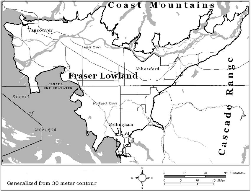
Fraser River Lowland
The Fraser River Lowland is a triangular area in southwestern British Columbia. The eastern apex of the triangle is at Hope, about 160 km inland from the Strait of Georgia. From here, the lowland broadens to the west to a width of about 50 km. The international boundary between British Columbia and Washington State crosses the southwestern part of the lowland. The Coast Mountains form the northern boundary of the delta-lowland. The Fraser River Lowland is the largest area of level land with suitable agricultural soils in coastal British Columbia.
"https://d3d0lqu00lnqvz.cloudfront.net/media/new_article_images/FraserRiverLowland/FraserRiverLowlandMap.png" // resources/views/front/categories/view.blade.php
https://d3d0lqu00lnqvz.cloudfront.net/media/new_article_images/FraserRiverLowland/FraserRiverLowlandMap.png