
Browse "Geographical Features"
-
Article
Western Interior Seaway (Plain-Language Summary)
The Western Interior Seaway was an ancient sea that covered some of North America during the Cretaceous (145–66 million years ago). At its largest, the seaway stretched about 5,000 km. It connected the Arctic Ocean with the Gulf of Mexico. This divided North America into two landmasses, Laramidia and Appalachia. The Western Interior Seaway was home to many organisms, including algae, ammonites, squid, crabs, fish, sharks, seabirds, turtles, crocodiles, mosasaurs, and plesiosaurs. Many of the natural resources mined in the prairies result from the Western Interior Seaway. Click here for definitions of key terms used in this article. This article is a plain-language summary of the Western Interior Seaway. If you are interested in reading about this topic more in depth, please see our full-length entry, Western Interior Seaway.
"https://d3d0lqu00lnqvz.cloudfront.net/westerninteriorseaway/Western-Interior-Seaway.jpg" // resources/views/front/categories/view.blade.php
https://d3d0lqu00lnqvz.cloudfront.net/westerninteriorseaway/Western-Interior-Seaway.jpg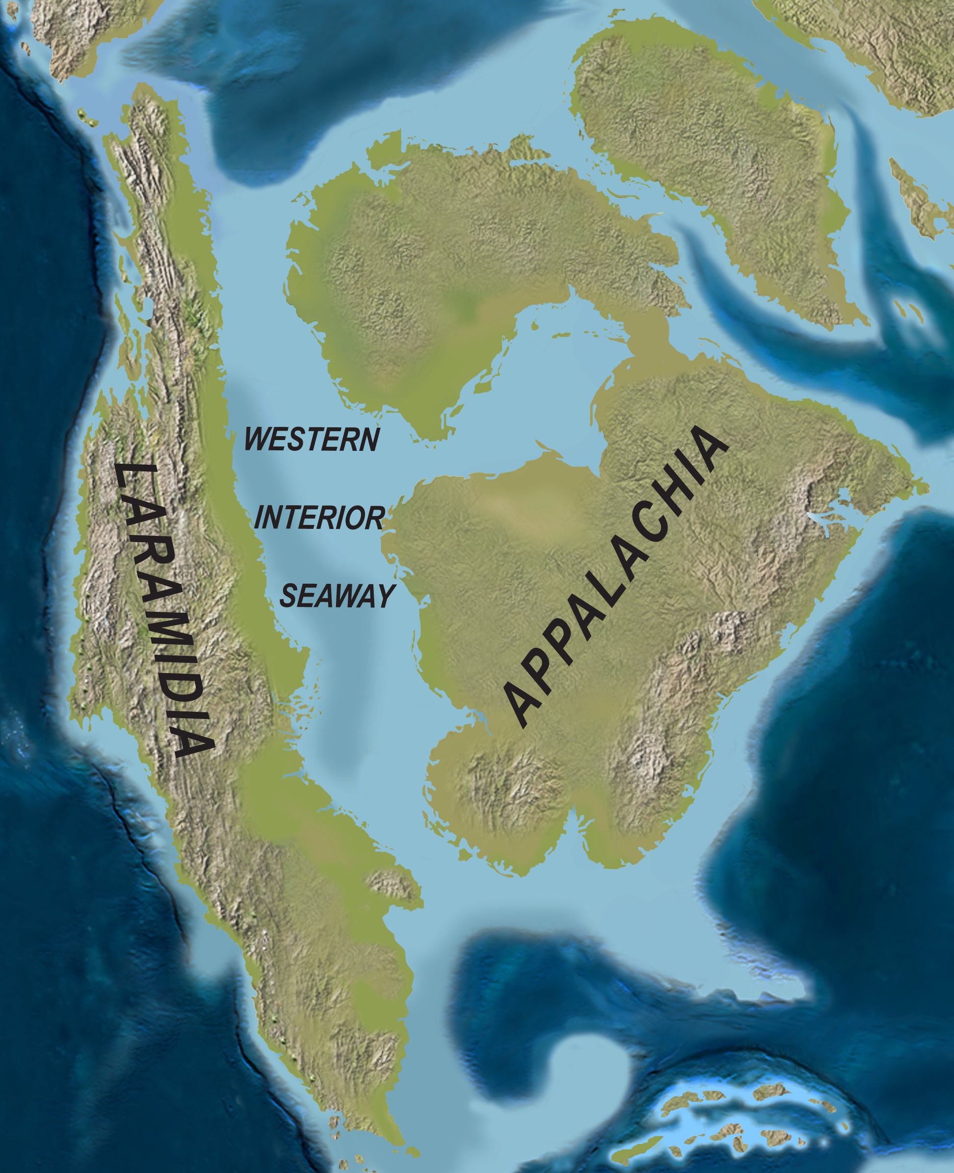
-
Article
White Pass
White Pass, elevation 888 m, sits on the Alaska-BC boundary, approximately 125 km south of Whitehorse, YT. In 1887 the federal government sent William Ogilvie to survey the 141st meridian national boundary where it crosses the Yukon River; members of his party found the pass.
"https://thecanadianencyclopedia.ca/images/tce_placeholder.jpg?v=e9dca980c9bdb3aa11e832e7ea94f5d9" // resources/views/front/categories/view.blade.php
https://thecanadianencyclopedia.ca/images/tce_placeholder.jpg?v=e9dca980c9bdb3aa11e832e7ea94f5d9
-
Article
Williston Lake
Williston Lake, 1761 km2, is the largest freshwater body in BC. Created in 1968 as the reservoir of the W.A.C.
"https://thecanadianencyclopedia.ca/images/tce_placeholder.jpg?v=e9dca980c9bdb3aa11e832e7ea94f5d9" // resources/views/front/categories/view.blade.php
https://thecanadianencyclopedia.ca/images/tce_placeholder.jpg?v=e9dca980c9bdb3aa11e832e7ea94f5d9
-
Article
Winisk River
Winisk River, 475 km long, rises in Wunnummin Lake in the Kenora District of northern Ontario.
"https://thecanadianencyclopedia.ca/images/tce_placeholder.jpg?v=e9dca980c9bdb3aa11e832e7ea94f5d9" // resources/views/front/categories/view.blade.php
https://thecanadianencyclopedia.ca/images/tce_placeholder.jpg?v=e9dca980c9bdb3aa11e832e7ea94f5d9
-
Article
Winnipeg River
Winnipeg River, 813 km long (to head of Firesteel River), issues from the north end of Lake of the Woods and flows northwest to Lake Winnipeg.
"https://thecanadianencyclopedia.ca/images/tce_placeholder.jpg?v=e9dca980c9bdb3aa11e832e7ea94f5d9" // resources/views/front/categories/view.blade.php
https://thecanadianencyclopedia.ca/images/tce_placeholder.jpg?v=e9dca980c9bdb3aa11e832e7ea94f5d9
-
Article
Wollaston Lake
Wollaston Lake, 2681 km2, elev 398 m, lies in the wooded Shield country of NE Saskatchewan.
"https://thecanadianencyclopedia.ca/images/tce_placeholder.jpg?v=e9dca980c9bdb3aa11e832e7ea94f5d9" // resources/views/front/categories/view.blade.php
https://thecanadianencyclopedia.ca/images/tce_placeholder.jpg?v=e9dca980c9bdb3aa11e832e7ea94f5d9
-
Article
Wood Mountain
Wood Mountain, elev 1000 m, is located about 135 km southwest of Moose Jaw, Sask, near the Forty-Ninth Parallel.
"https://thecanadianencyclopedia.ca/images/tce_placeholder.jpg?v=e9dca980c9bdb3aa11e832e7ea94f5d9" // resources/views/front/categories/view.blade.php
https://thecanadianencyclopedia.ca/images/tce_placeholder.jpg?v=e9dca980c9bdb3aa11e832e7ea94f5d9
-
Article
Wrangel Island
Wrangel Island lies in the Arctic Ocean 200 km N of the coast of eastern Siberia. Discovered in 1849, it was named in 1867 after Baron Wrangel, the Russian governor of Alaska. Though uninhabited, it served for 6 months in 1914
"https://thecanadianencyclopedia.ca/images/tce_placeholder.jpg?v=e9dca980c9bdb3aa11e832e7ea94f5d9" // resources/views/front/categories/view.blade.php
https://thecanadianencyclopedia.ca/images/tce_placeholder.jpg?v=e9dca980c9bdb3aa11e832e7ea94f5d9
-
Article
Yellowhead Pass
Yellowhead Pass, elev 1133 m, crosses the continental divide between Alberta and BC, 25 km W of JASPER. The Miette R flows E from the pass to meet the Athabasca R at Jasper. Yellowhead Lk, on the W side, empties into the Fraser River.
"https://thecanadianencyclopedia.ca/images/tce_placeholder.jpg?v=e9dca980c9bdb3aa11e832e7ea94f5d9" // resources/views/front/categories/view.blade.php
https://thecanadianencyclopedia.ca/images/tce_placeholder.jpg?v=e9dca980c9bdb3aa11e832e7ea94f5d9