
Browse "Geographical Features"
-
Article
Prince Charles Island
Prince Charles Island, Nunavut, 9521 km2, 130 km long and 100 km wide, is the largest island in Foxe Basin.
"https://thecanadianencyclopedia.ca/images/tce_placeholder.jpg?v=e9dca980c9bdb3aa11e832e7ea94f5d9" // resources/views/front/categories/view.blade.php
https://thecanadianencyclopedia.ca/images/tce_placeholder.jpg?v=e9dca980c9bdb3aa11e832e7ea94f5d9
-
Article
Prince of Wales Island
Prince of Wales Island, Nunavut, 33,339 km2, is the eighth-largest island in the Arctic Archipelago.
"https://d3d0lqu00lnqvz.cloudfront.net/Prince_of_Wales_Island.png" // resources/views/front/categories/view.blade.php
https://d3d0lqu00lnqvz.cloudfront.net/Prince_of_Wales_Island.png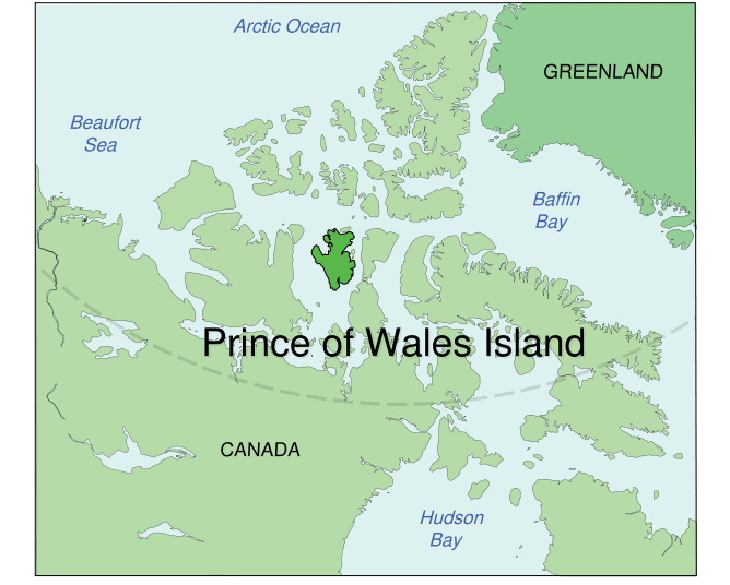
-
Article
Prince of Wales Strait
Prince of Wales Strait is situated in the Arctic Archipelago between the uplands of western Victoria Island and the east coast of Banks Island.
"https://d3d0lqu00lnqvz.cloudfront.net/media/media/6fcc972b-865e-4086-b585-c230cb7d350b.jpg" // resources/views/front/categories/view.blade.php
https://d3d0lqu00lnqvz.cloudfront.net/media/media/6fcc972b-865e-4086-b585-c230cb7d350b.jpg
-
Article
Prince Patrick Island
Prince Patrick Island, 15 848 km2, is the farthest west of Canada's Arctic Queen Elizabeth Islands.
"https://thecanadianencyclopedia.ca/images/tce_placeholder.jpg?v=e9dca980c9bdb3aa11e832e7ea94f5d9" // resources/views/front/categories/view.blade.php
https://thecanadianencyclopedia.ca/images/tce_placeholder.jpg?v=e9dca980c9bdb3aa11e832e7ea94f5d9
-
Article
Principal Reservoirs in Canada
Principal Reservoirs in Canada Principal Reservoirs in Canada Reservoir River Province Storage Capacity* Year Operational Lake St Lawrence St Lawrence Ontario 808 1958 Cross-Cedar Lake Saskatchewan Manitoba 9643 1965 Williston Lake Peace BC 70 309 1968 Manicouagan Manicouagan Québec 141 851 1968 Lake Diefenbaker South Saskatchewan Saskatchewan 9868 1972 Kinbasket Lake Columbia BC 24 670 1972 Wreck Cove Wreck Cove Nova Scotia 126 1978 Hinds Lake Humber Newfoundland 305 1980 SmallwoodChurchillLabrador28 0001971 *millions of cubic...
"https://thecanadianencyclopedia.ca/images/tce_placeholder.jpg?v=e9dca980c9bdb3aa11e832e7ea94f5d9" // resources/views/front/categories/view.blade.php
https://thecanadianencyclopedia.ca/images/tce_placeholder.jpg?v=e9dca980c9bdb3aa11e832e7ea94f5d9
-
"https://d3d0lqu00lnqvz.cloudfront.net/media/media/9b6a1cce-c95d-4cf8-ab82-694169a097f7.jpg" // resources/views/front/categories/view.blade.php
https://d3d0lqu00lnqvz.cloudfront.net/media/media/9b6a1cce-c95d-4cf8-ab82-694169a097f7.jpg
-
Article
Quadra Island
Quadra Island, BC, 270 km2, is situated at the North end of the Strait of Georgia between Vancouver Island and mainland BC, opposite Campbell River.
"https://thecanadianencyclopedia.ca/images/tce_placeholder.jpg?v=e9dca980c9bdb3aa11e832e7ea94f5d9" // resources/views/front/categories/view.blade.php
https://thecanadianencyclopedia.ca/images/tce_placeholder.jpg?v=e9dca980c9bdb3aa11e832e7ea94f5d9
-
Article
Qu'Appelle River
The Qu'Appelle River, 430 km long, rises in Lake Diefenbaker and meanders generally east across southern Saskatchewan, joining the Assiniboine River just east of the Manitoba border.
"https://thecanadianencyclopedia.ca/images/tce_placeholder.jpg?v=e9dca980c9bdb3aa11e832e7ea94f5d9" // resources/views/front/categories/view.blade.php
https://thecanadianencyclopedia.ca/images/tce_placeholder.jpg?v=e9dca980c9bdb3aa11e832e7ea94f5d9
-
Article
Quill Lakes
The Quill Lakes are three connected saline lakes in southeastern Saskatchewan. They are located 150 km north of Regina and 152 km east of Saskatoon. From west to east the lakes are named Big Quill, Middle Quill (also known as Mud Lake) and Little Quill. Despite its name, at 181 km2 Little Quill is the second largest of the three lakes. Big Quill is the largest at 307 km2. The Quill Lakes’ elevation is 516 m.
"https://thecanadianencyclopedia.ca/images/tce_placeholder.jpg?v=e9dca980c9bdb3aa11e832e7ea94f5d9" // resources/views/front/categories/view.blade.php
https://thecanadianencyclopedia.ca/images/tce_placeholder.jpg?v=e9dca980c9bdb3aa11e832e7ea94f5d9
-
Article
Rainy Lake
Rainy Lake, 932 km2 (741 km2 in Canada), elev 338 m, is located in rough woodlands astride the Ont-Minn border, 240 km W of Lk Superior. It discharges into the Rainy R, which flows W along the border to LK OF THE WOODS.
"https://thecanadianencyclopedia.ca/images/tce_placeholder.jpg?v=e9dca980c9bdb3aa11e832e7ea94f5d9" // resources/views/front/categories/view.blade.php
https://thecanadianencyclopedia.ca/images/tce_placeholder.jpg?v=e9dca980c9bdb3aa11e832e7ea94f5d9
-
Article
Random Island
Random Island, NL, 249 km2 is the second largest island off the Island of Newfoundland (FOGO ISLAND is larger at 254 km2). Random Island runs 40 km east-west and 14 km north-south, and is situated in a deep western indentation of TRINITY BAY.
"https://thecanadianencyclopedia.ca/images/tce_placeholder.jpg?v=e9dca980c9bdb3aa11e832e7ea94f5d9" // resources/views/front/categories/view.blade.php
https://thecanadianencyclopedia.ca/images/tce_placeholder.jpg?v=e9dca980c9bdb3aa11e832e7ea94f5d9
-
Article
Red Deer River
The Red Deer River (740 km, mean annual flow rate 62 m3/s), is glacier-fed by streams from Mount Drummond and Cyclone Mountain in the Rockies of Banff National Park in Alberta. It flows east then south to join the South SASKATCHEWAN RIVER just inside Saskatchewan.
"https://thecanadianencyclopedia.ca/images/tce_placeholder.jpg?v=e9dca980c9bdb3aa11e832e7ea94f5d9" // resources/views/front/categories/view.blade.php
https://thecanadianencyclopedia.ca/images/tce_placeholder.jpg?v=e9dca980c9bdb3aa11e832e7ea94f5d9
-
Article
Red Lake
Red Lake, Ontario, incorporated as a municipality in 1998, population 4,094 (2021 census), 4,107 (2016 census). The municipality of Red Lake is located in northwestern Ontario on the shore of Red Lake, 555 km northwest of Thunder Bay. The municipality is the result of the amalgamation of the former townships of Red Lake (incorporated in 1960) and Golden (established in 1985), and the unorganized territory governed by the Madsen local services board. Red Lake consists of six communities (Madsen, Red Lake, Balmertown, Cochenour, McKenzie Island and Starratt-Olsen) that sprang up around the area's gold mines.
"https://thecanadianencyclopedia.ca/images/tce_placeholder.jpg?v=e9dca980c9bdb3aa11e832e7ea94f5d9" // resources/views/front/categories/view.blade.php
https://thecanadianencyclopedia.ca/images/tce_placeholder.jpg?v=e9dca980c9bdb3aa11e832e7ea94f5d9
-
Article
Reindeer Lake
Reindeer Lake, 6650 km2, elev 337 m, max length 233 km, located on the border between northeastern Saskatchewan and northwestern Manitoba, is the second-largest lake in Saskatchewan and ninth largest in Canada. It has a heavily indented shoreline and contains numerous small islands.
"https://thecanadianencyclopedia.ca/images/tce_placeholder.jpg?v=e9dca980c9bdb3aa11e832e7ea94f5d9" // resources/views/front/categories/view.blade.php
https://thecanadianencyclopedia.ca/images/tce_placeholder.jpg?v=e9dca980c9bdb3aa11e832e7ea94f5d9
-
Article
Restigouche River
Restigouche River (Ristigouche in Québec), 200 km long, rises in the highlands of northwestern New Brunswick as the Little Main Restigouche River.
"https://thecanadianencyclopedia.ca/images/tce_placeholder.jpg?v=e9dca980c9bdb3aa11e832e7ea94f5d9" // resources/views/front/categories/view.blade.php
https://thecanadianencyclopedia.ca/images/tce_placeholder.jpg?v=e9dca980c9bdb3aa11e832e7ea94f5d9