
Browse "Geographical Features"
-
Article
Mount Edith Cavell
Mount Edith Cavell, elevation 3368 m, the highest mountain in the environs of Jasper, Alberta, is situated west of the Athabasca River, 24 km south of Jasper.
"https://thecanadianencyclopedia.ca/images/tce_placeholder.jpg?v=e9dca980c9bdb3aa11e832e7ea94f5d9" // resources/views/front/categories/view.blade.php
https://thecanadianencyclopedia.ca/images/tce_placeholder.jpg?v=e9dca980c9bdb3aa11e832e7ea94f5d9
-
Article
Mount Lucania
Lucania, Mount, elevation 5226 m, the third-highest mountain in Canada, is located 29 km east of the Alaska border and 50 km north of Mt LOGAN in the Yukon's St Elias Range. It was named by the duke of Abruzzi, who viewed it from Mount St Elias in 1897.
"https://thecanadianencyclopedia.ca/images/tce_placeholder.jpg?v=e9dca980c9bdb3aa11e832e7ea94f5d9" // resources/views/front/categories/view.blade.php
https://thecanadianencyclopedia.ca/images/tce_placeholder.jpg?v=e9dca980c9bdb3aa11e832e7ea94f5d9
-
Article
Mount Robson
Mount Robson, with a maximum elevation of 3,954 m, making it the highest mountain in the Canadian Rockies, is located 72 km northwest of Jasper townsite and 10 km southwest of the Continental Divide.
"https://d3d0lqu00lnqvz.cloudfront.net/mountrobson/mount-robson.jpg" // resources/views/front/categories/view.blade.php
https://d3d0lqu00lnqvz.cloudfront.net/mountrobson/mount-robson.jpg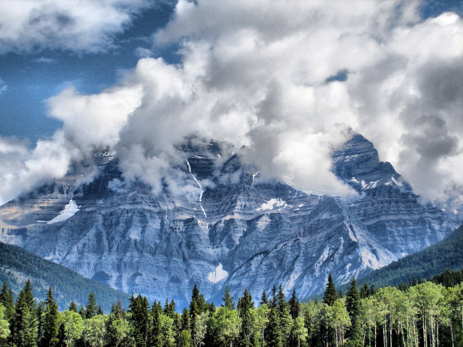
-
Article
Mount Royal
Mount Royal is a short mountain with a wide base covering ten square kilometres. It is close to the geographic centre of the Island of Montreal. Mount Royal is Montreal’s defining physical feature and a protected site; it was designated a Historic and Natural District by the government of Quebec in 2005. By law, new buildings in Montreal may not be taller than Mount Royal. The mountain occupies a central position, not only in the urban landscape of the city of Montreal, but also in its history, culture and society.
"https://d3d0lqu00lnqvz.cloudfront.net/media/media/Mount-Royal.jpg" // resources/views/front/categories/view.blade.php
https://d3d0lqu00lnqvz.cloudfront.net/media/media/Mount-Royal.jpg
-
Article
Mount Vancouver
Mount Vancouver, elevation 4785 m, situated in the Yukon Territory's St Elias Mountains, rises southeast of Mount Logan between 2 immense glacier systems, Hubbard and Seward.
"https://thecanadianencyclopedia.ca/images/tce_placeholder.jpg?v=e9dca980c9bdb3aa11e832e7ea94f5d9" // resources/views/front/categories/view.blade.php
https://thecanadianencyclopedia.ca/images/tce_placeholder.jpg?v=e9dca980c9bdb3aa11e832e7ea94f5d9
-
Article
Mount Waddington
Mount Waddington, elev 4016 m, the highest mountain in BC's Coast Mountains, rises near the head of Knight Inlet, 282 km NW of Vancouver.
"https://thecanadianencyclopedia.ca/images/tce_placeholder.jpg?v=e9dca980c9bdb3aa11e832e7ea94f5d9" // resources/views/front/categories/view.blade.php
https://thecanadianencyclopedia.ca/images/tce_placeholder.jpg?v=e9dca980c9bdb3aa11e832e7ea94f5d9
-
Article
Mountains in Canadian Music
Mountains. As an inspiration for Canadian music, mountains have enjoyed limited popularity. Not unexpectedly the mountains most often referred to are the Rockies of Alberta and British Columbia.
"https://thecanadianencyclopedia.ca/images/tce_placeholder.jpg?v=e9dca980c9bdb3aa11e832e7ea94f5d9" // resources/views/front/categories/view.blade.php
https://thecanadianencyclopedia.ca/images/tce_placeholder.jpg?v=e9dca980c9bdb3aa11e832e7ea94f5d9
-
Article
Nagwichoonjik Cultural Landscape
Nagwichoonjik, meaning "river flowing through a big country," is the Gwich'in name for the Mackenzie River, the longest river in Canada and the 9th longest river in the world. The river flows through the heart of the traditional homeland of the Gwichya Gwich'in, who now largely reside in Tsiigehtchic (formerly Arctic Red River), a small community of 200 people at the confluence of the Arctic Red and Mackenzie rivers, in the northern part of the Northwest Territories. ( See also Indigenous Territory).
"https://d3d0lqu00lnqvz.cloudfront.net/media/new_article_images/Tsiigehtchic/TsiigehtchicBothRivers.jpg" // resources/views/front/categories/view.blade.php
https://d3d0lqu00lnqvz.cloudfront.net/media/new_article_images/Tsiigehtchic/TsiigehtchicBothRivers.jpg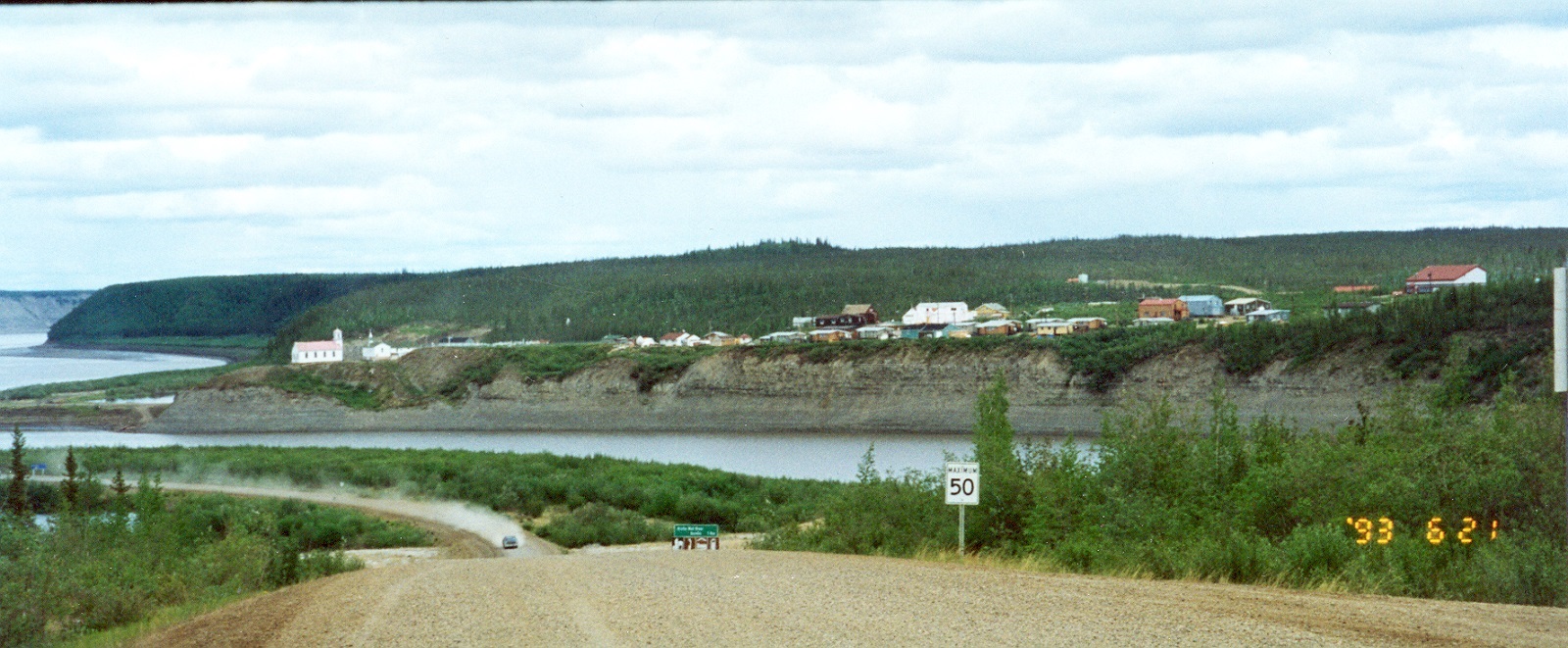
-
Article
Napaktulik Lake
Napaktulik Lake, 1080 km2, elevation 381 m, maximum length 60 km, is located in Nunavut almost on the Arctic Circle, 173 km south of Kugluktuk, NWT. The lake is fed by a tributary of the COPPERMINE RIVER and drains northeast to BATHURST INLET via the Hood River.
"https://thecanadianencyclopedia.ca/images/tce_placeholder.jpg?v=e9dca980c9bdb3aa11e832e7ea94f5d9" // resources/views/front/categories/view.blade.php
https://thecanadianencyclopedia.ca/images/tce_placeholder.jpg?v=e9dca980c9bdb3aa11e832e7ea94f5d9
-
Article
Nass River
Nass River is 380 km long, rises in the northern interior of BC and flows generally southwest, draining approximately 20 700 km2, to reach the Pacific at Portland Inlet. Its major tributaries are the Bell-Irving, Meziadin and Cranberry rivers.
"https://d3d0lqu00lnqvz.cloudfront.net/media/media/98c7f804-42d2-47dd-a13b-335cd43c959f.jpg" // resources/views/front/categories/view.blade.php
https://d3d0lqu00lnqvz.cloudfront.net/media/media/98c7f804-42d2-47dd-a13b-335cd43c959f.jpg
-
Article
Navy Island
Navy Island is the only Canadian island in the Niagara River. The 127.9 ha island is named after a British shipyard (1793) where the first naval vessels to sail the Upper Great Lakes were constructed.
"https://thecanadianencyclopedia.ca/images/tce_placeholder.jpg?v=e9dca980c9bdb3aa11e832e7ea94f5d9" // resources/views/front/categories/view.blade.php
https://thecanadianencyclopedia.ca/images/tce_placeholder.jpg?v=e9dca980c9bdb3aa11e832e7ea94f5d9
-
Article
Nelson River
The Nelson River, 2,575 km long, flows north northeast out of Playgreen Lake, at the northwest tip of Lake Winnipeg. It spills out into a number of lakes, including Cross, Sipiwesk, Split and Stevens, flowing east from the latter into Hudson Bay.
"https://thecanadianencyclopedia.ca/images/tce_placeholder.jpg?v=e9dca980c9bdb3aa11e832e7ea94f5d9" // resources/views/front/categories/view.blade.php
https://thecanadianencyclopedia.ca/images/tce_placeholder.jpg?v=e9dca980c9bdb3aa11e832e7ea94f5d9
-
Article
Nettilling Lake
Nettilling Lake, 5,542 km2, elevation 30 m, max length 123 km, is located toward the south end of Baffin Island. The lake is in the Great Plain of the Koukdjuak, about 110 km southwest of Auyuittuq National Parkand 280 km northwest of Iqaluit. The name is of Inuktitut origin but its meaning is unclear. (See also Largest Lakes in Canada.)
"https://thecanadianencyclopedia.ca/images/tce_placeholder.jpg?v=e9dca980c9bdb3aa11e832e7ea94f5d9" // resources/views/front/categories/view.blade.php
https://thecanadianencyclopedia.ca/images/tce_placeholder.jpg?v=e9dca980c9bdb3aa11e832e7ea94f5d9
-
Article
New Caledonia
New Caledonia ("New Scotland"), was a name given in 1806 to the central and highland plateau area of BRITISH COLUMBIA by Simon FRASER, a partner, trader and explorer in the NORTH WEST CO.
"https://thecanadianencyclopedia.ca/images/tce_placeholder.jpg?v=e9dca980c9bdb3aa11e832e7ea94f5d9" // resources/views/front/categories/view.blade.php
https://thecanadianencyclopedia.ca/images/tce_placeholder.jpg?v=e9dca980c9bdb3aa11e832e7ea94f5d9
-
Article
Niagara Falls (Waterfalls)
Niagara Falls, a spectacular waterfall in the Niagara River, is the world’s greatest waterfall by volume at 2,832 m3. It is split in two by Goat Island. The American Falls are 59 m high (21–34 m to rock debris at the base of the falls) and 260 m wide and carry about 10 per cent of the flow. The Canadian, or Horseshoe, Falls are 54 m high and 670 m wide, with the remaining 90 per cent of the flow. However, only the Canadian Falls fall freely to the Maid-of-the-Mist pool, where they have excavated a basin as deep or deeper than they are tall. The falls were formed some 14,000 years ago as retreating glaciers exposed the Niagara Escarpment, permitting the waters of Lake Erie, which formerly drained south, to flow northward into Lake Ontario.
"https://d3d0lqu00lnqvz.cloudfront.net/TCEImages/6ee4c921-2ba5-47cb-bfc5-8eebd83e3d65.jpg" // resources/views/front/categories/view.blade.php
https://d3d0lqu00lnqvz.cloudfront.net/TCEImages/6ee4c921-2ba5-47cb-bfc5-8eebd83e3d65.jpg