
Browse "Geographical Features"
-
Article
Main River
From its 4 headwater lakes (called Four Ponds - lakes are called "ponds" in Newfoundland and Labrador) in the Long Range Mountains on Newfoundland and Labrador's Great Northern Peninsula, the Main River drops quickly over boulder-strewn rapids.
"https://thecanadianencyclopedia.ca/images/tce_placeholder.jpg?v=e9dca980c9bdb3aa11e832e7ea94f5d9" // resources/views/front/categories/view.blade.php
https://thecanadianencyclopedia.ca/images/tce_placeholder.jpg?v=e9dca980c9bdb3aa11e832e7ea94f5d9
-
Article
Malpeque Bay
Malpeque Bay is a picturesque bay so deeply indented into the northeast coast of Prince Edward Island that its southern edge lies within 7 km of the south coast of the Island.
"https://thecanadianencyclopedia.ca/images/tce_placeholder.jpg?v=e9dca980c9bdb3aa11e832e7ea94f5d9" // resources/views/front/categories/view.blade.php
https://thecanadianencyclopedia.ca/images/tce_placeholder.jpg?v=e9dca980c9bdb3aa11e832e7ea94f5d9
-
Article
Mansel Island
Mansel Island, 112 km long by 48 km wide, is the smallest of 3 islands lying across the entrance to HUDSON BAY. Its topography features a gently undulating limestone lowland with elevations not exceeding 100 m.
"https://thecanadianencyclopedia.ca/images/tce_placeholder.jpg?v=e9dca980c9bdb3aa11e832e7ea94f5d9" // resources/views/front/categories/view.blade.php
https://thecanadianencyclopedia.ca/images/tce_placeholder.jpg?v=e9dca980c9bdb3aa11e832e7ea94f5d9
-
Article
Margaree River
The Margaree-Lake Ainslie system is the largest river system on Cape Breton Island, and one of the largest in Nova Scotia, with a total length of 120 km and a watershed of 1165 km2.
"https://thecanadianencyclopedia.ca/images/tce_placeholder.jpg?v=e9dca980c9bdb3aa11e832e7ea94f5d9" // resources/views/front/categories/view.blade.php
https://thecanadianencyclopedia.ca/images/tce_placeholder.jpg?v=e9dca980c9bdb3aa11e832e7ea94f5d9
-
Article
Mattawa River
The Mattawa River rises in Trout Lake in north-central Ontario, 198.5 m above sea level and drops to 50 m over around 65 km distance to the Ottawa River. Its watershed encompasses 1170 km2 of the Canadian Shield.
"https://thecanadianencyclopedia.ca/images/tce_placeholder.jpg?v=e9dca980c9bdb3aa11e832e7ea94f5d9" // resources/views/front/categories/view.blade.php
https://thecanadianencyclopedia.ca/images/tce_placeholder.jpg?v=e9dca980c9bdb3aa11e832e7ea94f5d9
-
Article
Meares Island
Meares Island, 84.8 km2 of dramatic terrain, temperate rain forest and sheltered tidal waters, is 2 km from Tofino, BC, in Clayoquot Sound. It was named in 1862 after John Meares. Its traditional name is Wanachus-Hilthuuis, from the Nuu-chah-nulth language.
"https://thecanadianencyclopedia.ca/images/tce_placeholder.jpg?v=e9dca980c9bdb3aa11e832e7ea94f5d9" // resources/views/front/categories/view.blade.php
https://thecanadianencyclopedia.ca/images/tce_placeholder.jpg?v=e9dca980c9bdb3aa11e832e7ea94f5d9
-
Article
Melville Island
Melville Island, 42 149 km 2 , is the fourth-largest of the QUEEN ELIZABETH ISLANDS . The Northwest Territories-Nunavut boundary splits the island in half. Its western half, which is in the Northwest Territories, is hilly,
"https://d3d0lqu00lnqvz.cloudfront.net/media/media/4ec28530-d4e5-4d8e-9ba1-9b66e7af9ec1.jpg" // resources/views/front/categories/view.blade.php
https://d3d0lqu00lnqvz.cloudfront.net/media/media/4ec28530-d4e5-4d8e-9ba1-9b66e7af9ec1.jpg
-
Article
Melville Peninsula
The Melville Peninsula is approximately 400 km long and 100 km wide. It is joined to the Canadian mainland by Rae Isthmus, is bounded on its west side by Committee Bay and is separated from BAFFIN ISLAND in the north by Fury and Hecla Strait; it faces FOXE BASIN in the east.
"https://thecanadianencyclopedia.ca/images/tce_placeholder.jpg?v=e9dca980c9bdb3aa11e832e7ea94f5d9" // resources/views/front/categories/view.blade.php
https://thecanadianencyclopedia.ca/images/tce_placeholder.jpg?v=e9dca980c9bdb3aa11e832e7ea94f5d9
-
Article
Metlakatla Pass Area
Metlakatla Pass, or Venn Passage, is located 4 km west of Prince Rupert on the northern BC coast.
"https://thecanadianencyclopedia.ca/images/tce_placeholder.jpg?v=e9dca980c9bdb3aa11e832e7ea94f5d9" // resources/views/front/categories/view.blade.php
https://thecanadianencyclopedia.ca/images/tce_placeholder.jpg?v=e9dca980c9bdb3aa11e832e7ea94f5d9
-
Article
Minas Basin
Minas Basin is the broadest part of the south-eastern head of the Bay of FUNDY and lies entirely within Nova Scotia. It merges westward into Fundy, through Minas Channel, 5 km wide, and eastward into Cobequid Bay, and is widest (30 km) south of Parrsboro, Nova Scotia.
"https://d3d0lqu00lnqvz.cloudfront.net/media/media/be636a29-f69f-4cdf-b060-f5c1dba7c65e.jpg" // resources/views/front/categories/view.blade.php
https://d3d0lqu00lnqvz.cloudfront.net/media/media/be636a29-f69f-4cdf-b060-f5c1dba7c65e.jpg
-
Article
Miramichi River
The Miramichi River is 217 km long from its source in Juniper, in central New Brunswick, to the Gulf of St. Lawrence.
"https://d3d0lqu00lnqvz.cloudfront.net/media/media/169334dd-4829-4936-a09b-b91e809c65ef.jpg" // resources/views/front/categories/view.blade.php
https://d3d0lqu00lnqvz.cloudfront.net/media/media/169334dd-4829-4936-a09b-b91e809c65ef.jpg
-
Article
Miscou Island
Miscou Island, 64 km2, comprises the most eastern part of Gloucester County, New Brunswick, on the west side of the Gulf of St Lawrence and at the entrance to CHALEUR BAY.
"https://thecanadianencyclopedia.ca/images/tce_placeholder.jpg?v=e9dca980c9bdb3aa11e832e7ea94f5d9" // resources/views/front/categories/view.blade.php
https://thecanadianencyclopedia.ca/images/tce_placeholder.jpg?v=e9dca980c9bdb3aa11e832e7ea94f5d9
-
Article
Mont Sainte-Anne
Internationally known for its SKIING facilities, 7 World Cup races have been held there since 1969. The area is superbly equipped; downhill skiers and snowboarders enjoy 51 runs totalling 60 km (15 km are illuminated for night skiing).
"https://d3d0lqu00lnqvz.cloudfront.net/media/media/d7932e1a-76b9-4c9e-bbb5-1ffc418839f7.jpg" // resources/views/front/categories/view.blade.php
https://d3d0lqu00lnqvz.cloudfront.net/media/media/d7932e1a-76b9-4c9e-bbb5-1ffc418839f7.jpg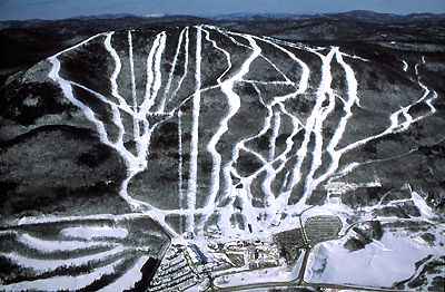
-
Article
Moose River
The Moose River is 547 km long from the head of its tributary, the Mattagami River. It is formed by the confluence of the Mattagami and the Missinaibi rivers, and flows northeast 104 km to discharge into the bottom of James Bay in northern Ontario.
"https://thecanadianencyclopedia.ca/images/tce_placeholder.jpg?v=e9dca980c9bdb3aa11e832e7ea94f5d9" // resources/views/front/categories/view.blade.php
https://thecanadianencyclopedia.ca/images/tce_placeholder.jpg?v=e9dca980c9bdb3aa11e832e7ea94f5d9
-
Article
Mount Assiniboine
Mount Assiniboine, elevation 3618 m, the highest mountain between the Trans-Canada Highway and the US border in the Rocky Mts, is often called "The Matterhorn of the Canadian Rockies."
"https://thecanadianencyclopedia.ca/images/tce_placeholder.jpg?v=e9dca980c9bdb3aa11e832e7ea94f5d9" // resources/views/front/categories/view.blade.php
https://thecanadianencyclopedia.ca/images/tce_placeholder.jpg?v=e9dca980c9bdb3aa11e832e7ea94f5d9