Browse "Geographical Features"
-
Article
Kicking Horse Pass
Kicking Horse Pass is a route through the Rocky Mountains. At an elevation of 1,627 m, Kicking Horse Pass straddles the Continental Divide on the border between Alberta and British Columbia in Yoho National Park. In 1971, Kicking Horse Pass was designated a National Historic Site for its importance as a transportation corridor in Western Canada, first for Indigenous peoples, then the Canadian Pacific Railway, and finally the Trans-Canada Highway.
"https://d3d0lqu00lnqvz.cloudfront.net/media/media/c2e8193c-32fb-430e-b2c8-7399eee67818.jpg" // resources/views/front/categories/view.blade.php
https://d3d0lqu00lnqvz.cloudfront.net/media/media/c2e8193c-32fb-430e-b2c8-7399eee67818.jpg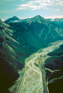
-
Article
Kicking Horse River
The Kicking Horse River begins as glacial meltwater streams flowing down the west slope of the Rocky Mountains.
"https://thecanadianencyclopedia.ca/images/tce_placeholder.jpg?v=e9dca980c9bdb3aa11e832e7ea94f5d9" // resources/views/front/categories/view.blade.php
https://thecanadianencyclopedia.ca/images/tce_placeholder.jpg?v=e9dca980c9bdb3aa11e832e7ea94f5d9
-
Article
Killiniq Island
Killiniq Island, 269 km2, is located off the northern tip of the Labrador Peninsula on the south side of the entrance to Hudson Strait. The provincial boundary passes across the island, so that its eastern portion belongs to Newfoundland and the rest is part of Nunavut.
"https://thecanadianencyclopedia.ca/images/tce_placeholder.jpg?v=e9dca980c9bdb3aa11e832e7ea94f5d9" // resources/views/front/categories/view.blade.php
https://thecanadianencyclopedia.ca/images/tce_placeholder.jpg?v=e9dca980c9bdb3aa11e832e7ea94f5d9
-
"https://d3d0lqu00lnqvz.cloudfront.net/media/media/53c26b08-3e98-4cb1-b146-fc3654a0854a.jpg" // resources/views/front/categories/view.blade.php
https://d3d0lqu00lnqvz.cloudfront.net/media/media/53c26b08-3e98-4cb1-b146-fc3654a0854a.jpg
-
Article
Kootenay Lake
Kootenay Lake, 407 km2, elev 532 m, is situated in the mountainous southeastern interior of BC.
"https://d3d0lqu00lnqvz.cloudfront.net/media/media/889433fb-787d-4d50-9c0d-a3cfcfcff6a5.jpg" // resources/views/front/categories/view.blade.php
https://d3d0lqu00lnqvz.cloudfront.net/media/media/889433fb-787d-4d50-9c0d-a3cfcfcff6a5.jpg
-
Article
Labrador Current
The Labrador Current, famous for icebergs and once-abundant cod fish, is a southeasterly flow of water over the continental shelf and slope east of Newfoundland and Labrador, between Hudson Strait and the southern tip of the Grand Banks.
"https://thecanadianencyclopedia.ca/images/tce_placeholder.jpg?v=e9dca980c9bdb3aa11e832e7ea94f5d9" // resources/views/front/categories/view.blade.php
https://thecanadianencyclopedia.ca/images/tce_placeholder.jpg?v=e9dca980c9bdb3aa11e832e7ea94f5d9
-
Article
Labrador Highlands
Formed of ancient Precambrian rocks and heavily glaciated during the Quaternary (1.65 million to 10 000 years ago), the mountains support more than 70 small glaciers, the southernmost in eastern North America.
"https://thecanadianencyclopedia.ca/images/tce_placeholder.jpg?v=e9dca980c9bdb3aa11e832e7ea94f5d9" // resources/views/front/categories/view.blade.php
https://thecanadianencyclopedia.ca/images/tce_placeholder.jpg?v=e9dca980c9bdb3aa11e832e7ea94f5d9
-
Article
Labrador Sea
Labrador Sea is the body of water between Greenland and the coast of Labrador. It is 3400 m deep and 1000 km wide where it joins the North Atlantic and shallows to less than 700 m where DAVIS STRAIT separates it from BAFFIN BAY.
"https://thecanadianencyclopedia.ca/images/tce_placeholder.jpg?v=e9dca980c9bdb3aa11e832e7ea94f5d9" // resources/views/front/categories/view.blade.php
https://thecanadianencyclopedia.ca/images/tce_placeholder.jpg?v=e9dca980c9bdb3aa11e832e7ea94f5d9
-
Article
Lac à l' Eau Claire
Lac à l'Eau Claire, 1383 km2, elevation 241 m, max length 71 km, is located in northwestern Québec about 133 km east of the southeastern shore of Hudson Bay. Probably formed by the impact of a METEORITE, the lake drains west via Rivière à l'Eau Claire into Lac GUILLAUME-DELISLE.
"https://thecanadianencyclopedia.ca/images/tce_placeholder.jpg?v=e9dca980c9bdb3aa11e832e7ea94f5d9" // resources/views/front/categories/view.blade.php
https://thecanadianencyclopedia.ca/images/tce_placeholder.jpg?v=e9dca980c9bdb3aa11e832e7ea94f5d9
-
Article
Lac Bienville
Lac Bienville, 1249 km2, elevation 426 m, maximum length 89 km, is located in a sparsely populated region of northern Québec. This elongated lake, dotted with numerous islands, is fed by Lacs Louet and Ossant. It drains west, via the Grande Rivière de la Baleine (Great Whale River), into Hudson Bay.
"https://thecanadianencyclopedia.ca/images/tce_placeholder.jpg?v=e9dca980c9bdb3aa11e832e7ea94f5d9" // resources/views/front/categories/view.blade.php
https://thecanadianencyclopedia.ca/images/tce_placeholder.jpg?v=e9dca980c9bdb3aa11e832e7ea94f5d9
-
Article
Lac Guillaume-Delisle
Lac Guillaume-Delisle, 712 km2, is a large, triangular, saltwater lake in northern Québec, connected to the eastern shore of Hudson Bay by Le Goulet, a 5 km long narrow channel.
"https://thecanadianencyclopedia.ca/images/tce_placeholder.jpg?v=e9dca980c9bdb3aa11e832e7ea94f5d9" // resources/views/front/categories/view.blade.php
https://thecanadianencyclopedia.ca/images/tce_placeholder.jpg?v=e9dca980c9bdb3aa11e832e7ea94f5d9
-
Article
Lac la Martre
Lac la Martre, 1777 km2, elev 265 m, max length 76 km, is located in the Northwest Territories, 50 km west of Behchokò and 150 km northwest of Yellowknife, and 346 km south of the Arctic Circle. The settlement of WHATÌ is located at the southeastern corner of the lake.
"https://thecanadianencyclopedia.ca/images/tce_placeholder.jpg?v=e9dca980c9bdb3aa11e832e7ea94f5d9" // resources/views/front/categories/view.blade.php
https://thecanadianencyclopedia.ca/images/tce_placeholder.jpg?v=e9dca980c9bdb3aa11e832e7ea94f5d9
-
Article
Lac La Ronge
Lac La Ronge, 1414 km2, elevation 364 m, is located in the rugged, sparsely populated Canadian Shield country of central Saskatchewan, 235 km north of Prince Albert. About 58 km long and studded with many islands, it drains northeast via the Rapid River into the Churchill River.
"https://thecanadianencyclopedia.ca/images/tce_placeholder.jpg?v=e9dca980c9bdb3aa11e832e7ea94f5d9" // resources/views/front/categories/view.blade.php
https://thecanadianencyclopedia.ca/images/tce_placeholder.jpg?v=e9dca980c9bdb3aa11e832e7ea94f5d9
-
Article
Lac Mistassini
Lac Mistassini, 2335 km2, elevation 372 m, max length 161 km and width 19 km, is located in central Québec, 360 km east of JAMES BAY and 220 km northwest of Lac SAINT-JEAN.
"https://thecanadianencyclopedia.ca/images/tce_placeholder.jpg?v=e9dca980c9bdb3aa11e832e7ea94f5d9" // resources/views/front/categories/view.blade.php
https://thecanadianencyclopedia.ca/images/tce_placeholder.jpg?v=e9dca980c9bdb3aa11e832e7ea94f5d9
-
Article
Lac Saint-Jean
Lac Saint-Jean, 1,003 km2, elevation 98 m, 63 m deep, is located in south-central Quebec, 206 km north of the St. Lawrence River, into which it flows via Saguenay River.
"https://d3d0lqu00lnqvz.cloudfront.net/13082433704_13129d1f88_k.jpg" // resources/views/front/categories/view.blade.php
https://d3d0lqu00lnqvz.cloudfront.net/13082433704_13129d1f88_k.jpg