
Browse "Cities & Populated Places"
-
Article
The Pas
The Pas, Manitoba, incorporated as a town in 1912, population 5,639 (2021 census), 5,369 (2016 census). The town of The Pas is located on the south bank of the Saskatchewan River, about 60 km northwest of where the river enters Cedar Lake.
"https://thecanadianencyclopedia.ca/images/tce_placeholder.jpg?v=e9dca980c9bdb3aa11e832e7ea94f5d9" // resources/views/front/categories/view.blade.php
https://thecanadianencyclopedia.ca/images/tce_placeholder.jpg?v=e9dca980c9bdb3aa11e832e7ea94f5d9
-
Article
Thetford Mines
Thetford Mines, Quebec, incorporated as a city in 1905, population 26,072 (2021 census), population 25,403 (2016 census). The city of Thetford Mines is located on the Bécancour River in the Appalachian Mountains, 107 km south of Quebec City. It was named after the town of Thetford in Norfolk, England. During the 20th century, it was one of the world’s largest asbestos mining and production centres.
"https://d3d0lqu00lnqvz.cloudfront.net/media/new_article_images/ThetfordMines/ThetfordMines.jpg" // resources/views/front/categories/view.blade.php
https://d3d0lqu00lnqvz.cloudfront.net/media/new_article_images/ThetfordMines/ThetfordMines.jpg
-
Article
Thompson
Thompson, Manitoba, incorporated as a city in 1970, population 12 829 (2011c), 13 446 (2006c). The City of Thompson is located on the south side of the Burntwood River, 740 km north of Winnipeg.
"https://d3d0lqu00lnqvz.cloudfront.net/media/media/47481ba8-856b-414e-a45d-175e7b331f81.jpg" // resources/views/front/categories/view.blade.php
https://d3d0lqu00lnqvz.cloudfront.net/media/media/47481ba8-856b-414e-a45d-175e7b331f81.jpg
-
Article
Thorold
Thorold, Ont, incorporated as a city in 1975, population 17 931 (2011c), 18 224 (2006c). The City of Thorold is situated on the NIAGARA PENINSULA. Though physically linked to ST CATHARINES, its large neighbour directly to the
"https://thecanadianencyclopedia.ca/images/tce_placeholder.jpg?v=e9dca980c9bdb3aa11e832e7ea94f5d9" // resources/views/front/categories/view.blade.php
https://thecanadianencyclopedia.ca/images/tce_placeholder.jpg?v=e9dca980c9bdb3aa11e832e7ea94f5d9
-
Article
Three Hills
Three Hills, Alta, incorporated as a town in 1929, population 3198 (2011c), 3089 (2006c). The Town of Three Hills is located 128 km northeast of Calgary. Three Hills takes its name from 3 prominent hills to the north of the town.
"https://d3d0lqu00lnqvz.cloudfront.net/media/media/5ecb9aa6-e6d7-420b-a068-c8a30e4d9c1c.jpg" // resources/views/front/categories/view.blade.php
https://d3d0lqu00lnqvz.cloudfront.net/media/media/5ecb9aa6-e6d7-420b-a068-c8a30e4d9c1c.jpg
-
Article
Thunder Bay
Thunder Bay, ON, incorporated as a city in 1970, population 108,843 (2021 census), 107,909 (2016 census). The City of Thunder Bay was created by the amalgamation of the cities of Fort William and Port Arthur and the townships of Neebing and McIntyre. It is located in northwestern Ontario on the west shore of the Lake Superior bay of the same name. Thunder Bay is situated on the traditional territory of the Anishinaabeg, and the land is covered by the Robinson-Superior Treaty. The Port of Thunder Bay is a western stop along the Great Lakes-St Lawrence Seaway. The region’s geography is dominated by the rocks, lakes and forests of the Canadian Shield. Surrounding communities depend on tourism or resource extraction and look to Thunder Bay for a wide variety of services.
"https://d3d0lqu00lnqvz.cloudfront.net/media/new_article_images/ThunderBay/12171019064_8ca50f0bb8_z.jpg" // resources/views/front/categories/view.blade.php
https://d3d0lqu00lnqvz.cloudfront.net/media/new_article_images/ThunderBay/12171019064_8ca50f0bb8_z.jpg
-
Article
Tignish
Today, Tignish is 93% Roman Catholic and more than 20% of the population can speak both French and English. The co-operative movement has been one of the community's most distinctive features.
"https://thecanadianencyclopedia.ca/images/tce_placeholder.jpg?v=e9dca980c9bdb3aa11e832e7ea94f5d9" // resources/views/front/categories/view.blade.php
https://thecanadianencyclopedia.ca/images/tce_placeholder.jpg?v=e9dca980c9bdb3aa11e832e7ea94f5d9
-
Article
Tilbury
Tilbury, Ont, urban area, population 4700 (2011c), 4809 (2006c). Tilbury is located 56 km east of WINDSOR. It was a town from 1910 to 1998, when it was amalgamated with the new municipality of CHATHAM-KENT.
"https://thecanadianencyclopedia.ca/images/tce_placeholder.jpg?v=e9dca980c9bdb3aa11e832e7ea94f5d9" // resources/views/front/categories/view.blade.php
https://thecanadianencyclopedia.ca/images/tce_placeholder.jpg?v=e9dca980c9bdb3aa11e832e7ea94f5d9
-
Article
Tillsonburg
Tillsonburg, Ont, incorporated as a town in 1872, population 15 301 (2011c), 14 822 (2006c). The Town of Tillsonburg is located in Oxford County, 40 km east of ST THOMAS. Founder George Tillson arrived in 1825 and opened a forge
"https://thecanadianencyclopedia.ca/images/tce_placeholder.jpg?v=e9dca980c9bdb3aa11e832e7ea94f5d9" // resources/views/front/categories/view.blade.php
https://thecanadianencyclopedia.ca/images/tce_placeholder.jpg?v=e9dca980c9bdb3aa11e832e7ea94f5d9
-
Article
Timmins
Timmins, Ontario, incorporated as a city in 1973, population 41,145 (2021 census), 41,788 (2016 census). The city of Timmins is located 290 km northwest of Greater Sudbury.
"https://d3d0lqu00lnqvz.cloudfront.net/media/media/77a2b646-1dd7-44c2-8094-136b666d627e.jpg" // resources/views/front/categories/view.blade.php
https://d3d0lqu00lnqvz.cloudfront.net/media/media/77a2b646-1dd7-44c2-8094-136b666d627e.jpg
-
Article
Tisdale
Tisdale, Sask, incorporated as a town in 1920, population 3180 (2011c), 3000 (2006c). The Town of Tisdale is located at a railway junction, 135 km southeast of Prince Albert. Originally called Doghide after nearby Doghide Creek
"https://thecanadianencyclopedia.ca/images/tce_placeholder.jpg?v=e9dca980c9bdb3aa11e832e7ea94f5d9" // resources/views/front/categories/view.blade.php
https://thecanadianencyclopedia.ca/images/tce_placeholder.jpg?v=e9dca980c9bdb3aa11e832e7ea94f5d9
-
Article
Tofino
Tofino, British Columbia, incorporated as a municipality in 1932 and as a district in 1982, population 1,932 (2016 census), 1,876 (2011 census). The community of Tofino is located on the west coast of Vancouver Island, 317 km northwest of Victoria by road, on the northern tip of the Esowista Peninsula and the south side of Clayoquot Sound. The district encompasses an area of 19.09 km2 within the Clayoquot Sound Biosphere Reserve. Tofino developed around fishing and logging industries and is now a popular tourist destination, sought for its natural beauty and outdoor recreation.
"https://d3d0lqu00lnqvz.cloudfront.net/media/media/cf105f8b-4748-4771-8ad9-45931da863f2.jpg" // resources/views/front/categories/view.blade.php
https://d3d0lqu00lnqvz.cloudfront.net/media/media/cf105f8b-4748-4771-8ad9-45931da863f2.jpg
-
Article
Torbay
Torbay, NL, incorporated as a town in 1972, population 7397 (2011c), 6281 (2006c). The Town of Torbay is located 10 km north of ST JOHN'S overlooking Torbay Bight.
"https://thecanadianencyclopedia.ca/images/tce_placeholder.jpg?v=e9dca980c9bdb3aa11e832e7ea94f5d9" // resources/views/front/categories/view.blade.php
https://thecanadianencyclopedia.ca/images/tce_placeholder.jpg?v=e9dca980c9bdb3aa11e832e7ea94f5d9
-
Article
Toronto's Chinatowns
Toronto’s Chinatown, one of the largest in North America, is an ever-evolving neighbourhood defined by numerous cohorts of Chinese immigrants with a diversity of culture, traditions and languages. (See Chinese Canadians.) Also known as Chinatown West, it is one of three Chinatowns in Toronto, more of the large Chinese settlements are included from the inner suburbs, like Scarborough and North York, and outer suburbs, like Markham, Mississauga and Richmond Hill.
"https://d3d0lqu00lnqvz.cloudfront.net/!feature-img-thumbnails/tor-cn-feat.jpg" // resources/views/front/categories/view.blade.php
https://d3d0lqu00lnqvz.cloudfront.net/!feature-img-thumbnails/tor-cn-feat.jpg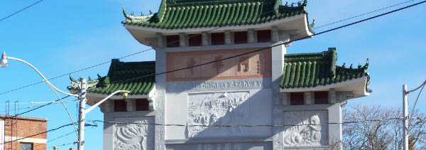
-
Article
Toronto Feature: Black Creek Pioneer Village
This article is from our Toronto Feature series. Features from past programs are not updated.
"https://d3d0lqu00lnqvz.cloudfront.net/media/media/708727f3-b6c9-4b49-8662-d311b5803b6b.jpg" // resources/views/front/categories/view.blade.php
https://d3d0lqu00lnqvz.cloudfront.net/media/media/708727f3-b6c9-4b49-8662-d311b5803b6b.jpg