
Browse "Cities & Populated Places"
-
Article
Stoney Creek
The first European settlers, primarily LOYALISTS, arrived from the US in 1786. The area was cleared for mixed farming and Stoney Creek attracted many saw and grain mills and other agricultural service activities.
"https://thecanadianencyclopedia.ca/images/tce_placeholder.jpg?v=e9dca980c9bdb3aa11e832e7ea94f5d9" // resources/views/front/categories/view.blade.php
https://thecanadianencyclopedia.ca/images/tce_placeholder.jpg?v=e9dca980c9bdb3aa11e832e7ea94f5d9
-
Article
Stony Plain
Stony Plain, Alta, incorporated as a town in 1908, population 15 051 (2011c), 12 363 (2006c). The Town of Stony Plain is located about 25 km west of EDMONTON. Settlement began in 1881 about 3 km south of the present town. This settlement was called Dogrump Creek but in 1892 was renamed Stony Plain.
"https://thecanadianencyclopedia.ca/images/tce_placeholder.jpg?v=e9dca980c9bdb3aa11e832e7ea94f5d9" // resources/views/front/categories/view.blade.php
https://thecanadianencyclopedia.ca/images/tce_placeholder.jpg?v=e9dca980c9bdb3aa11e832e7ea94f5d9
-
Article
Stratford
Urban growth was slow until the railway-building boom of the 1850s. Stratford businessmen lobbied for the forming in 1853 of the County of Perth, with Stratford as the county seat, and the county at once voted bonuses to railway companies.
"https://d3d0lqu00lnqvz.cloudfront.net/media/media/664057ff-dd11-4f37-abff-a514d6fb143e.jpg" // resources/views/front/categories/view.blade.php
https://d3d0lqu00lnqvz.cloudfront.net/media/media/664057ff-dd11-4f37-abff-a514d6fb143e.jpg
-
Article
Strathmore
Strathmore, Alta, incorporated as a town in 1911, population 12 305 (2011c), 10 280 (2006c). The Town of Strathmore is located 40 km east of CALGARY. Strathmore was named after Charles Bowes-Lyon, 13th earl of Strathmore (1824-1904), a forefather of Queen Elizabeth II.
"https://d3d0lqu00lnqvz.cloudfront.net/media/media/210a4861-11eb-4238-97ad-3bdd221a3b60.jpg" // resources/views/front/categories/view.blade.php
https://d3d0lqu00lnqvz.cloudfront.net/media/media/210a4861-11eb-4238-97ad-3bdd221a3b60.jpg
-
Article
Strathroy-Caradoc
During its early history Strathroy suffered a number of devastating fires. In 1868 a blaze wiped out a considerable portion of Strathroy's business section. Several fires in manufacturing plants in the late 1890s and an agricultural depression caused a period of economic downturn for the town.
"https://d3d0lqu00lnqvz.cloudfront.net/media/media/997b9858-a7a8-4f8a-8880-76bd7d7f9b96.jpg" // resources/views/front/categories/view.blade.php
https://d3d0lqu00lnqvz.cloudfront.net/media/media/997b9858-a7a8-4f8a-8880-76bd7d7f9b96.jpg
-
Article
Sturgeon Falls
Sturgeon Falls, Ontario, population centre, population 6,939 (2021 census), 6,916 (2016 census). Sturgeon Falls is located 5 km up the Sturgeon River from Lake Nipissing. It was incorporated as a town in 1895. After a failed court challenge aimed at maintaining a separate identity (1997), Sturgeon Falls is now the administrative centre for the provincially-mandated town of West Nipissing (incorporated 1990).
"https://thecanadianencyclopedia.ca/images/tce_placeholder.jpg?v=e9dca980c9bdb3aa11e832e7ea94f5d9" // resources/views/front/categories/view.blade.php
https://thecanadianencyclopedia.ca/images/tce_placeholder.jpg?v=e9dca980c9bdb3aa11e832e7ea94f5d9
-
Article
Sudbury
Greater Sudbury, Ontario, incorporated as a city in 2001, population 166,004 (2021 census), 161,531 (2016 census). The judicial seat for the District of Sudbury, the City of Greater Sudbury is located on the western shore of Ramsey Lake, about 60 km north of Georgian Bay. When incorporated in 2001, it replaced the former Regional Municipality of Sudbury (1973–2000) and City of Sudbury (1930–2000). The city owes much of its development to the mining industry, in particular, the mining of nickel. The largest urban area in northeastern Ontario, Greater Sudbury, now offers a concentration of business, cultural and educational services and is recognized for the impressive regreening program that it has been carrying out since the 1970s.
"https://d3d0lqu00lnqvz.cloudfront.net/media/media/4508a162-1478-4016-a9fe-a629711736ab.jpg" // resources/views/front/categories/view.blade.php
https://d3d0lqu00lnqvz.cloudfront.net/media/media/4508a162-1478-4016-a9fe-a629711736ab.jpg
-
Article
Summerland
Summerland, BC, incorporated as a district municipality in 1906, population 11 280 (2011c), 10 828 (2006c). The District of Summerland is located on the west bank of OKANAGAN LAKE in the southern interior of British Columbia between KELOWNA and PENTICTON.
"https://d3d0lqu00lnqvz.cloudfront.net/media/media/0244c898-89ec-490e-8fce-58f57b91df26.jpg" // resources/views/front/categories/view.blade.php
https://d3d0lqu00lnqvz.cloudfront.net/media/media/0244c898-89ec-490e-8fce-58f57b91df26.jpg
-
Article
Summerside
Beginning around 1910, the town experienced renewed prosperity as a fur-trading centre, stimulated by Sir Charles Dalton and Robert T. Oulton's successful breeding of silver foxes in captivity. In 1920 Summerside was established as the headquarters of the Canadian National Silver Fox Breeders' Assn.
"https://d3d0lqu00lnqvz.cloudfront.net/media/media/c92b22e5-2797-46d3-bd33-d318ecb6cc64.jpg" // resources/views/front/categories/view.blade.php
https://d3d0lqu00lnqvz.cloudfront.net/media/media/c92b22e5-2797-46d3-bd33-d318ecb6cc64.jpg
-
"https://d3d0lqu00lnqvz.cloudfront.net/media/media/a75c407d-aa04-450d-9516-94bdc0f4f3f3.jpg" // resources/views/front/categories/view.blade.php
https://d3d0lqu00lnqvz.cloudfront.net/media/media/a75c407d-aa04-450d-9516-94bdc0f4f3f3.jpg
-
Article
Surrey
Surrey, British Columbia, incorporated as a city in 1993, population 568,322 (2021 census), 517,887 (2016 census). The city of Surrey is the second-largest municipality by population in British Columbia, after Vancouver. Part of Metro Vancouver, it is bounded by the Fraser River on the north and Washington state on the south. The municipalities of Langley and Delta lie to the east and west.
"https://thecanadianencyclopedia.ca/images/tce_placeholder.jpg?v=e9dca980c9bdb3aa11e832e7ea94f5d9" // resources/views/front/categories/view.blade.php
https://thecanadianencyclopedia.ca/images/tce_placeholder.jpg?v=e9dca980c9bdb3aa11e832e7ea94f5d9
-
Article
Sussex
Sussex, New Brunswick, incorporated as a town in 1904, population 4,440 (2021 census), 4,282 (2016 census). The Town of Sussex is located in south-central New Brunswick in a rich agricultural area, 73 km from Saint John on the Kennebecasis River.
"https://thecanadianencyclopedia.ca/images/tce_placeholder.jpg?v=e9dca980c9bdb3aa11e832e7ea94f5d9" // resources/views/front/categories/view.blade.php
https://thecanadianencyclopedia.ca/images/tce_placeholder.jpg?v=e9dca980c9bdb3aa11e832e7ea94f5d9
-
Article
Swan Hills
Swan Hills, Alta, incorporated as a town in 1967, population 1465 (2011c), 1645 (2006c). The Town of Swan Hills is located in the Swan Hills, 209 km northwest of Edmonton. The Swan Hills were named by the Cree for legendary giant swans whose thundering wings would fill the air.
"https://d3d0lqu00lnqvz.cloudfront.net/media/media/c832dba4-b8a8-4794-a903-4d960dbe55b2.jpg" // resources/views/front/categories/view.blade.php
https://d3d0lqu00lnqvz.cloudfront.net/media/media/c832dba4-b8a8-4794-a903-4d960dbe55b2.jpg
-
Article
Swift Current
Swift Current began to adopt the persona of a community in 1883 with the appearance of a dam, water tank, freight sheds, roadhouse and dining room. For many years it has served a large ranching, mixed-farming and grain-farming area.
"https://d3d0lqu00lnqvz.cloudfront.net/media/media/5ff60670-5d29-40af-bc8c-2490e8c26d9d.jpg" // resources/views/front/categories/view.blade.php
https://d3d0lqu00lnqvz.cloudfront.net/media/media/5ff60670-5d29-40af-bc8c-2490e8c26d9d.jpg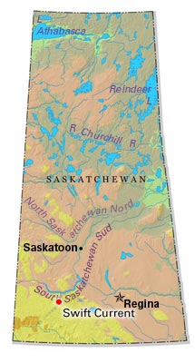
-
Article
Sydney
Sydney, Nova Scotia, incorporated as a city in 1900, population 30,960 (2021 census), 30,170 (2016 census). Sydney is located near the eastern extremity of Cape Breton Island. It is the centre of the second-largest urban complex in Nova Scotia, Cape Breton Regional Municipality (1995). Its fine harbour, known as Spanish Bay in colonial times, is ringed by the richest coalfield in eastern Canada. Since 1900, it has been noted for its huge steel mill, the largest and most modern in Canada at its construction. The industrial core around the mill has been in decline since the end of the Second World War as the coal mines of the surrounding communities became less productive and the obsolete steel mill less competitive with central Canadian producers.
"https://d3d0lqu00lnqvz.cloudfront.net/media/media/de26e0a9-50cb-48be-bf77-273aa9c599f6.jpg" // resources/views/front/categories/view.blade.php
https://d3d0lqu00lnqvz.cloudfront.net/media/media/de26e0a9-50cb-48be-bf77-273aa9c599f6.jpg