
Browse "Cities & Populated Places"
-
Article
Naujaat
Naujaat, Nunavut, incorporated as a hamlet in 1978, population 1,225 (2021 census), 1,082 (2016 census). The hamlet of Naujaat is located on the north shore of Repulse Bay, which is on the south shore of the Rae Isthmus. For a period of time, Naujaat was known as Repulse Bay.
"https://thecanadianencyclopedia.ca/images/tce_placeholder.jpg?v=e9dca980c9bdb3aa11e832e7ea94f5d9" // resources/views/front/categories/view.blade.php
https://thecanadianencyclopedia.ca/images/tce_placeholder.jpg?v=e9dca980c9bdb3aa11e832e7ea94f5d9
-
Article
Reserves in British Columbia
As of 2019, there were 1,583 reserves in British Columbia associated with 203 Indigenous Nations (see also First Nations in British Columbia). Unlike many other parts the country, where reserves resulted from treaties made between the federal government and Indigenous Nations, most reserves in BC were created without such negotiations. Only two general locations in BC are covered by historic treaties: parts of Vancouver Island are covered by the Douglas Treaties, and the northeast corner of the province by Treaty 8. In BC as with other parts of the country, reserves are bound by the terms of the Indian Act. However, given the number of Indigenous Nations without a treaty in BC, the province has implemented a modern treaty negotiation process. Several BC Indigenous communities have used this process or other means to negotiate self-governing agreements. These agreements place decision-making authority over land management in the hands of Indigenous governments.
"https://d3d0lqu00lnqvz.cloudfront.net/ReservesInBC/TribalCanoeJourney.jpg" // resources/views/front/categories/view.blade.php
https://d3d0lqu00lnqvz.cloudfront.net/ReservesInBC/TribalCanoeJourney.jpg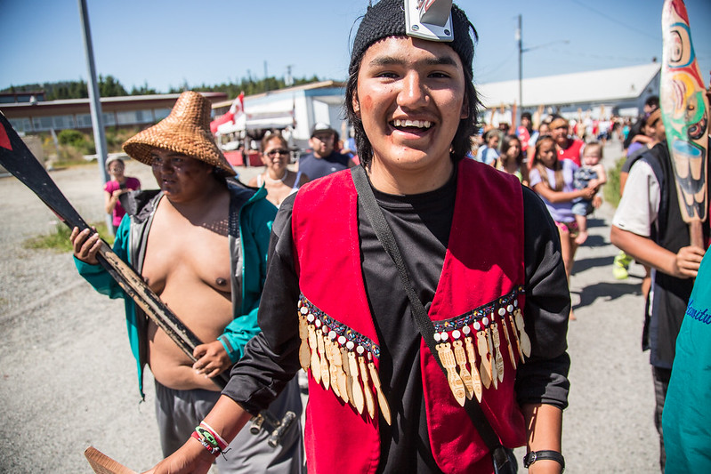
-
Article
Reserves in Canada (Plain-Language Summary)
A reserve is land set aside by the Canadian government for use by First Nations. Reserves are managed under the Indian Act. Reserves are places where First Nations often live. However, some reserves are only for practices like hunting. Not all First Nations have reserve lands. There are reserves in every province in Canada, but most are in rural or remote areas. Few reserves have been established in the territories. (This is a plain-language summary of Reserves in Canada. If you are interested in reading about this topic in more depth, please see our full-length entry, Reserves in Canada.)
"https://d3d0lqu00lnqvz.cloudfront.net/media/media/98f21d5f-b51e-4f33-8760-a876daffe0cd.jpg" // resources/views/front/categories/view.blade.php
https://d3d0lqu00lnqvz.cloudfront.net/media/media/98f21d5f-b51e-4f33-8760-a876daffe0cd.jpg
-
Article
Reserves in New Brunswick
There are 31 reserves in New Brunswick held by 15 First Nations (see alsoFirst Nations in New Brunswick). These First Nations belong to one of two larger cultural groups, namely the Mi’kmaq or Wolastoqiyik (Maliseet), who are, in turn, part of the Wabanaki Confederacy. Reserve names and boundaries have changed through time and some reserves either no longer exist or are not recognized by the provincial government. As of 2021, there were 16,985 Registered Indians in New Brunswick, about 59 per cent of whom lived on reserves.
"https://d3d0lqu00lnqvz.cloudfront.net/ReservesinNB/PotatoPickers.jpg" // resources/views/front/categories/view.blade.php
https://d3d0lqu00lnqvz.cloudfront.net/ReservesinNB/PotatoPickers.jpg
-
Article
Reserves in Nova Scotia
There are 42 reserves in Nova Scotia, held by 13 First Nations (see First Nations in Nova Scotia). Nova Scotia is one of just two provinces, the other being Prince Edward Island, that is part of the traditional territory of only one Indigenous people. In both cases, it is the Mi'kmaq. In 2020, there were 17,895 registered Mi’kmaq in Nova Scotia, about 63 per cent of whom (11,202 people) lived on reserve. Reserves in Nova Scotia vary in size from over 3,500 hectares to less than one, though almost every First Nation has more than one land tract.
"https://d3d0lqu00lnqvz.cloudfront.net/media/media/c46f71fe-d1d5-47bd-9ee6-bfeaa4810e03.jpg" // resources/views/front/categories/view.blade.php
https://d3d0lqu00lnqvz.cloudfront.net/media/media/c46f71fe-d1d5-47bd-9ee6-bfeaa4810e03.jpg
-
Article
Reserves in Quebec
There are 30 reserves in Quebec, held by 25 of the province's 40 First Nations (see also First Nations in Quebec). In addition, there are 14 Inuit, 9 Cree and 1 Naskapi community whose lands fall under the jurisdiction of the James Bay and Northern Quebec Agreement and the Northeastern Quebec Agreement. Because they are not governed by the Indian Act, these communities are technically not reserves. There are also five First Nations in Quebec that do not have reserve lands (Long Point First Nation, Communauté anicinape de Kitcisakik, Wolf Lake First Nation, Montagnais de Pakua Shipi and Nation MicMac de Gespeg). This is the largest number of First Nations without reserve land of any province. Finally, the Mohawk Council of Akwesasne has a reserve that is partly in Quebec, Ontario and New York state. As of 2020, there were 92,762 registered Indians in Quebec, 64 per cent of whom live on reserve.
"https://d3d0lqu00lnqvz.cloudfront.net/media/new_article_images/ReservesinQC/Powwow.jpg" // resources/views/front/categories/view.blade.php
https://d3d0lqu00lnqvz.cloudfront.net/media/new_article_images/ReservesinQC/Powwow.jpg
-
Article
Reserves in Saskatchewan
Saskatchewan is home to at least 70 First Nations and various Métis communities. It contains 782 reserves, settlements and villages, many of which are located in the southern half of the province. Reserves in Saskatchewan were created between 1874 and 1906 by Treaties 2, 4, 5, 6, 8 and 10. As of 2016, 47.5 per cent of the province’s 114,570 self-identified First Nations peoples live on reserves, a percentage comparable to the province of Manitoba. Most of the remaining 47 per cent who reside off-reserve in Saskatchewan live in the cities of Saskatoon, Regina and Prince Albert.
"https://d3d0lqu00lnqvz.cloudfront.net/media/new_article_images/ReservesSK/Flag of Thunderchild First Nation.jpg" // resources/views/front/categories/view.blade.php
https://d3d0lqu00lnqvz.cloudfront.net/media/new_article_images/ReservesSK/Flag of Thunderchild First Nation.jpg
-
Article
Resolute
Resolute, Nunavut, incorporated as a hamlet in 1987, population 198 (2021 census), 183 (2016 census). The Hamlet of Resolute is located on the south coast of Cornwallis Island in the Arctic Archipelago, near the middle of the Northwest Passage. It is the second most northern community in both Nunavut and Canada and is far enough North that the sun never sets in the summer.
"https://d3d0lqu00lnqvz.cloudfront.net/resolute/Resolute.jpg" // resources/views/front/categories/view.blade.php
https://d3d0lqu00lnqvz.cloudfront.net/resolute/Resolute.jpg
-
Article
Revelstoke
Revelstoke, British Columbia, incorporated as a city in 1899, population 7,547 (2016 census), 7,139 (2011 census). The city of Revelstoke is situated on the Columbia River between the Selkirk and Monashee mountains. It is on the Trans-Canada Highway at the western entrance to Rogers Pass and Mount Revelstoke and Glacier national parks. Revelstoke is located on the traditional territory of the Ktunaxa, Sinixt, Secwepemc and Okanagan peoples. (See also Interior Salish.)
"https://d3d0lqu00lnqvz.cloudfront.net/media/media/d1ad52d1-3866-4ccd-9454-4d28fb26ee18.jpg" // resources/views/front/categories/view.blade.php
https://d3d0lqu00lnqvz.cloudfront.net/media/media/d1ad52d1-3866-4ccd-9454-4d28fb26ee18.jpg
-
Macleans
Revelstoke Avalanche Deaths Raise Questions About Backcountry Safety
RICH MARSHALL, back from a therapeutic ski trek with his wife, Abby Watkins, sits at the kitchen table of their home in Golden, B.C., attempting to describe the godawful choices thrust upon them on Feb. 1 by chance, by training and, as they see it, by a duty to help.This article was originally published in Maclean's Magazine on February 17, 2003
"https://thecanadianencyclopedia.ca/images/tce_placeholder.jpg?v=e9dca980c9bdb3aa11e832e7ea94f5d9" // resources/views/front/categories/view.blade.php
https://thecanadianencyclopedia.ca/images/tce_placeholder.jpg?v=e9dca980c9bdb3aa11e832e7ea94f5d9
-
Article
Rexton
Rexton, NB, incorporated as a village in 1966, population 818 (2011c), 862 (2006c). The Village of Rexton is located in southeastern New Brunswick, at the mouth of the Richibucto River.
"https://thecanadianencyclopedia.ca/images/tce_placeholder.jpg?v=e9dca980c9bdb3aa11e832e7ea94f5d9" // resources/views/front/categories/view.blade.php
https://thecanadianencyclopedia.ca/images/tce_placeholder.jpg?v=e9dca980c9bdb3aa11e832e7ea94f5d9
-
Article
Richmond
Richmond, British Columbia, incorporated as a city in 1990, population 209,937 (2021 census), 198,309 (2016 census). The City of Richmond is located adjacent to and south of Vancouver and west of New Westminster. The city comprises Sea Island, most of Lulu Island and 12 smaller islands in the delta of the Fraser River. Due to its culturally diverse populace, the city provides many services in different languages. Vancouver International Airport is located in Richmond.
"https://thecanadianencyclopedia.ca/images/tce_placeholder.jpg?v=e9dca980c9bdb3aa11e832e7ea94f5d9" // resources/views/front/categories/view.blade.php
https://thecanadianencyclopedia.ca/images/tce_placeholder.jpg?v=e9dca980c9bdb3aa11e832e7ea94f5d9
-
Article
Richmond Hill
Richmond Hill, Ontario, is a city 23 km north of Lake Ontario, population 202,022 (2021 census), 195,022 (2016 census). It is one of nine municipalities that make up the Regional Municipality of York. The city is bordered by Aurora to the north, Whitchurch-Stouffville to the east, Markham to the east and south, Vaughan to the west and south, and King Township to the west. Richmond Hill became an incorporated village in 1872, changing status to town in 1957, and city in 2019. The modern borders were established in 1971 from the Town of Richmond Hill, as well as parts of King, Vaughan, Whitchurch and Markham Townships. Throughout history, the Richmond Hill area has been home to different Indigenous groups, namely the Huron Wendat, Haudenosaunee and Anishinaabeg. The land is covered by Treaty 13 and the Williams Treaties.
"https://d3d0lqu00lnqvz.cloudfront.net/media/new_article_images/RichmondHill/DowntownRichmondHill.jpg" // resources/views/front/categories/view.blade.php
https://d3d0lqu00lnqvz.cloudfront.net/media/new_article_images/RichmondHill/DowntownRichmondHill.jpg
-
Article
Rimouski
In the 18th century, agriculture and seasonal fishing were the only occupations, but the area experienced some growth when Québec City merchants, including William Price, began to develop the forest resources and built several sawmills.
"https://thecanadianencyclopedia.ca/images/tce_placeholder.jpg?v=e9dca980c9bdb3aa11e832e7ea94f5d9" // resources/views/front/categories/view.blade.php
https://thecanadianencyclopedia.ca/images/tce_placeholder.jpg?v=e9dca980c9bdb3aa11e832e7ea94f5d9
-
Article
Riverview
Riverview, incorporated as a town in 1973, population 19 128 (2011c), 17 832 (2006c). The Town of Riverview is situated on the Petitcodiac River opposite MONCTON.
"https://thecanadianencyclopedia.ca/images/tce_placeholder.jpg?v=e9dca980c9bdb3aa11e832e7ea94f5d9" // resources/views/front/categories/view.blade.php
https://thecanadianencyclopedia.ca/images/tce_placeholder.jpg?v=e9dca980c9bdb3aa11e832e7ea94f5d9