
Browse "Cities & Populated Places"
-
Article
Lumsden
Lumsden, Sask, incorporated as a town in 1905, population 1631 (2011c), 1523 (2006c). The Town of Lumsden is located 26 km northeast of REGINA, nestled in the rolling terrain of the QU'APPELLE RIVER valley. The first settlers arrived in 1881 and named their community Happy Hollow.
"https://thecanadianencyclopedia.ca/images/tce_placeholder.jpg?v=e9dca980c9bdb3aa11e832e7ea94f5d9" // resources/views/front/categories/view.blade.php
https://thecanadianencyclopedia.ca/images/tce_placeholder.jpg?v=e9dca980c9bdb3aa11e832e7ea94f5d9
-
Article
Lunenburg
Lunenburg, Nova Scotia, incorporated as a town in 1888, population 2,405 (2021 census), 2,262 (2016 census). The town of Lunenburg, the seat of Lunenburg County, is located on Lunenburg Bay, 90 km southwest of Halifax.
"https://d3d0lqu00lnqvz.cloudfront.net/lunenburg/lunenburg-waterfront.jpg" // resources/views/front/categories/view.blade.php
https://d3d0lqu00lnqvz.cloudfront.net/lunenburg/lunenburg-waterfront.jpg
-
Article
Lynn Lake
Lynn Lake, Manitoba, incorporated as a town in 1997, population 482 (2011c), 714 (2006c). The Town of Lynn Lake is a community located 1066 km by road northwest of Winnipeg on the Canadian SHIELD.
"https://thecanadianencyclopedia.ca/images/tce_placeholder.jpg?v=e9dca980c9bdb3aa11e832e7ea94f5d9" // resources/views/front/categories/view.blade.php
https://thecanadianencyclopedia.ca/images/tce_placeholder.jpg?v=e9dca980c9bdb3aa11e832e7ea94f5d9
-
Article
Lytton
Lytton, British Columbia, incorporated as a village in 1945, population 249 (2016 census), 228 (2011 census). The village of Lytton is located on the Trans-Canada Highway, 260 km northeast of Vancouver, at the junction of the Thompson and Fraser rivers. This is one of the driest and warmest spots in Canada.
"https://d3d0lqu00lnqvz.cloudfront.net/media/media/597fe6e1-a416-4a06-8227-f84345c5562b.jpg" // resources/views/front/categories/view.blade.php
https://d3d0lqu00lnqvz.cloudfront.net/media/media/597fe6e1-a416-4a06-8227-f84345c5562b.jpg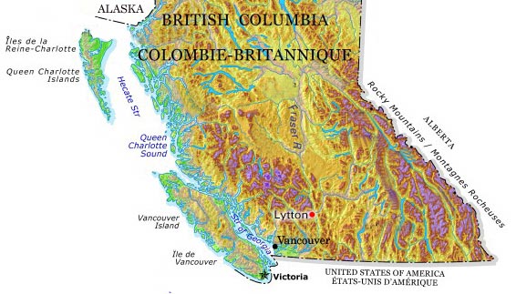
-
Article
Mackenzie
Mackenzie, BC, incorporated as a district municipality in 1966, population 3507 (2011c), 4539 (2006c). The District of Mackenzie is situated in northern British Columbia near the south end of Williston Lake in the Rocky Mountain Trench.
"https://thecanadianencyclopedia.ca/images/tce_placeholder.jpg?v=e9dca980c9bdb3aa11e832e7ea94f5d9" // resources/views/front/categories/view.blade.php
https://thecanadianencyclopedia.ca/images/tce_placeholder.jpg?v=e9dca980c9bdb3aa11e832e7ea94f5d9
-
Article
Magog
In 1888 the village of Magog separated from the municipality of Magog Township (established 1855) and soon incorporated as a town.
"https://thecanadianencyclopedia.ca/images/tce_placeholder.jpg?v=e9dca980c9bdb3aa11e832e7ea94f5d9" // resources/views/front/categories/view.blade.php
https://thecanadianencyclopedia.ca/images/tce_placeholder.jpg?v=e9dca980c9bdb3aa11e832e7ea94f5d9
-
Article
Mahone Bay
Mahone Bay, NS, incorporated as a town in 1919, population 943 (2011c), 904 (2006c). The Town of Mahone Bay is located on the "Lighthouse Route" of Nova Scotia's southern shore, 10 km northwest of LUNENBURG.
"https://thecanadianencyclopedia.ca/images/tce_placeholder.jpg?v=e9dca980c9bdb3aa11e832e7ea94f5d9" // resources/views/front/categories/view.blade.php
https://thecanadianencyclopedia.ca/images/tce_placeholder.jpg?v=e9dca980c9bdb3aa11e832e7ea94f5d9
-
Article
Malartic
Malartic, Qué, Town, pop 3640 (2006c), 3704 (2001c), inc 1939. Malartic is located 70 km east of ROUYN-NORANDA in northwestern Québec. It was established by Québec's Ministry of Mines, which hoped to end the
"https://thecanadianencyclopedia.ca/images/tce_placeholder.jpg?v=e9dca980c9bdb3aa11e832e7ea94f5d9" // resources/views/front/categories/view.blade.php
https://thecanadianencyclopedia.ca/images/tce_placeholder.jpg?v=e9dca980c9bdb3aa11e832e7ea94f5d9
-
Article
Manitouwadge
Manitouwadge, Ont, incorporated as a township in 1975, population 2105 (2011c), 2300 (2006c). The Township of Manitouwadge is located in northwestern Ontario 397 km northeast of Thunder Bay.
"https://thecanadianencyclopedia.ca/images/tce_placeholder.jpg?v=e9dca980c9bdb3aa11e832e7ea94f5d9" // resources/views/front/categories/view.blade.php
https://thecanadianencyclopedia.ca/images/tce_placeholder.jpg?v=e9dca980c9bdb3aa11e832e7ea94f5d9
-
Article
Maniwaki
The Oblate Fathers founded the mission Notre-Dame du Désert in 1849. Soon after, many settlers moved into the area, drawn by the forest's economic potential. A forest industry was established and provided the livelihood for the residents of the region. In 1851, Maniwaki was declared a parish.
"https://thecanadianencyclopedia.ca/images/tce_placeholder.jpg?v=e9dca980c9bdb3aa11e832e7ea94f5d9" // resources/views/front/categories/view.blade.php
https://thecanadianencyclopedia.ca/images/tce_placeholder.jpg?v=e9dca980c9bdb3aa11e832e7ea94f5d9
-
Article
Manning
Manning, Alta, incorporated as a village in 1951 and as a town in 1957, population 1164 (2011c), 1493 (2006c). The Town of Manning lies beside the Notikewin River, 73 km north of the town of PEACE RIVER.
"https://thecanadianencyclopedia.ca/images/tce_placeholder.jpg?v=e9dca980c9bdb3aa11e832e7ea94f5d9" // resources/views/front/categories/view.blade.php
https://thecanadianencyclopedia.ca/images/tce_placeholder.jpg?v=e9dca980c9bdb3aa11e832e7ea94f5d9
-
Article
Maple Ridge
Maple Ridge, BC, incorporated as a district municipality in 1874, population 76 052 (2011c), 68 949 (2006c). The District of Maple Ridge is located 40 km east of VANCOUVER, bounded by the FRASER RIVER on the south and on the north by the Golden Ears Mountain.
"https://thecanadianencyclopedia.ca/images/tce_placeholder.jpg?v=e9dca980c9bdb3aa11e832e7ea94f5d9" // resources/views/front/categories/view.blade.php
https://thecanadianencyclopedia.ca/images/tce_placeholder.jpg?v=e9dca980c9bdb3aa11e832e7ea94f5d9
-
Article
Markham
Markham, Ontario, incorporated as a city in 1971, population 338,503 (2021 census), 328,966 (2016 census). Markham is located immediately northeast of Toronto. It is one of nine municipalities that make up the Regional Municipality of York. The Rouge River cuts through the municipality diagonally, connecting to Rouge National Urban Park. Initially an agricultural community, Markham is now known for its technology businesses and ethnocultural diversity. Throughout history, the Markham area has been home to different Indigenous groups, namely the Huron Wendat, Haudenosaunee and Anishinaabeg. The land is covered by Treaty 13 and the Williams Treaties.
"https://d3d0lqu00lnqvz.cloudfront.net/media/new_article_images/Markham/PacificMall.jpg" // resources/views/front/categories/view.blade.php
https://d3d0lqu00lnqvz.cloudfront.net/media/new_article_images/Markham/PacificMall.jpg
-
Article
Marshall
Marshall, Sask, incorporated as a village in 1914 and as a town in 2006, population 533 (2011c), 608 (2006c). The Town of Marshall is located on the Canadian National Railway line and the Yellowhead Highway between LLOYDMINSTER and NORTH BATTLEFORD, in the Rural Municipality of WILTON.
"https://thecanadianencyclopedia.ca/images/tce_placeholder.jpg?v=e9dca980c9bdb3aa11e832e7ea94f5d9" // resources/views/front/categories/view.blade.php
https://thecanadianencyclopedia.ca/images/tce_placeholder.jpg?v=e9dca980c9bdb3aa11e832e7ea94f5d9
-
Article
Martensville
Martensville, Sask, incorporated as a town in 1969 and a city in 2009, population 7716 (2011c), 4978 (2006c). The City of Martensville is located 9 km north of SASKATOON. In the late 1960s as Saskatoon's population underwent
"https://thecanadianencyclopedia.ca/images/tce_placeholder.jpg?v=e9dca980c9bdb3aa11e832e7ea94f5d9" // resources/views/front/categories/view.blade.php
https://thecanadianencyclopedia.ca/images/tce_placeholder.jpg?v=e9dca980c9bdb3aa11e832e7ea94f5d9