
Browse "Cities & Populated Places"
-
Article
Anjou
First part of the parish municipality of Saint-Léonard-de-Port-Maurice from 1886 to 1916, it was set up as a separate municipality in 1916 and incorporated as a city 50 years later.
"https://thecanadianencyclopedia.ca/images/tce_placeholder.jpg?v=e9dca980c9bdb3aa11e832e7ea94f5d9" // resources/views/front/categories/view.blade.php
https://thecanadianencyclopedia.ca/images/tce_placeholder.jpg?v=e9dca980c9bdb3aa11e832e7ea94f5d9
-
Article
Annapolis Royal
Annapolis Royal, NS, incorporated as a town in 1893, population 481 (2011c), 444 (2006c). The Town of Annapolis Royal is located on the south side of the Annapolis River, about 10 km from its mouth near the western shore of Nova Scotia.
"https://d3d0lqu00lnqvz.cloudfront.net/media/media/3a7c4fed-361c-4480-87bf-5cde577568f1.jpg" // resources/views/front/categories/view.blade.php
https://d3d0lqu00lnqvz.cloudfront.net/media/media/3a7c4fed-361c-4480-87bf-5cde577568f1.jpg
-
Article
Antigonish
Antigonish, NS, incorporated as a town in 1889, population 4524 (2011c), 4236 (2006c). The Town of Antigonish is situated on a small plain just over a kilometre from Antigonish Harbour. Located midway between Halifax and Sydney.
"https://thecanadianencyclopedia.ca/images/tce_placeholder.jpg?v=e9dca980c9bdb3aa11e832e7ea94f5d9" // resources/views/front/categories/view.blade.php
https://thecanadianencyclopedia.ca/images/tce_placeholder.jpg?v=e9dca980c9bdb3aa11e832e7ea94f5d9
-
Article
Anyox
Anyox, BC, was a town situated on Granby Bay, 60 km north of Prince Rupert. The Tsimshian word means "hidden water.
"https://thecanadianencyclopedia.ca/images/tce_placeholder.jpg?v=e9dca980c9bdb3aa11e832e7ea94f5d9" // resources/views/front/categories/view.blade.php
https://thecanadianencyclopedia.ca/images/tce_placeholder.jpg?v=e9dca980c9bdb3aa11e832e7ea94f5d9
-
Article
Argentia
Argentia, NL, Unincorporated Place. Argentia is located on the west coast of the Avalon Peninsula of Newfoundland.
"https://thecanadianencyclopedia.ca/images/tce_placeholder.jpg?v=e9dca980c9bdb3aa11e832e7ea94f5d9" // resources/views/front/categories/view.blade.php
https://thecanadianencyclopedia.ca/images/tce_placeholder.jpg?v=e9dca980c9bdb3aa11e832e7ea94f5d9
-
Article
Arnprior
Arnprior, Ont, incorporated as a town in 1892, population 8114 (2011c), 7158 (2006c). The Town of Arnprior is located at the confluence of the Madawaska and Ottawa rivers, 56 km west of Ottawa.
"https://thecanadianencyclopedia.ca/images/tce_placeholder.jpg?v=e9dca980c9bdb3aa11e832e7ea94f5d9" // resources/views/front/categories/view.blade.php
https://thecanadianencyclopedia.ca/images/tce_placeholder.jpg?v=e9dca980c9bdb3aa11e832e7ea94f5d9
-
Article
Arthabaska
The founder of Arthabaska, Charles Beauchesne, arrived in 1834 and was impressed by the size of the trees and quality of the soil. The first industries were potash and maple-sugar production.
"https://d3d0lqu00lnqvz.cloudfront.net/media/media/4a328ded-ba4b-4436-9bf9-1636dd1a2779.jpg" // resources/views/front/categories/view.blade.php
https://d3d0lqu00lnqvz.cloudfront.net/media/media/4a328ded-ba4b-4436-9bf9-1636dd1a2779.jpg
-
Article
Arviat
Arviat, Nunavut, incorporated as a hamlet in 1977, population 2318 (2011c), 2060 (2006c). The Hamlet of Arviat is located on the west coast of Hudson Bay and is the southern-most community of mainland Nunavut.
"https://thecanadianencyclopedia.ca/images/tce_placeholder.jpg?v=e9dca980c9bdb3aa11e832e7ea94f5d9" // resources/views/front/categories/view.blade.php
https://thecanadianencyclopedia.ca/images/tce_placeholder.jpg?v=e9dca980c9bdb3aa11e832e7ea94f5d9
-
Article
Val-des-Sources (Asbestos)
Val-des-Sources, Quebec, incorporated as a village in 1899 and as a town in 1937, population 7,088 (2021 census), 6,786 (2016 census). The town of Val-des-Sources is located in the Eastern Townships region, 53 km north of Sherbrooke and 58 km southeast of Drummondville. Originally called Asbestos, the town was named after the mineral mined there from 1881 to 2011. During that time, Asbestos produced much of the world’s supply of the asbestos mineral, which is now banned in many countries because of its negative health effects. Asbestos was renamed Val-des-Sources in December 2020. Val-des-Sources is located on ancestral Abenaki lands. The land is unceded and is considered Indigenous territory.
"https://d3d0lqu00lnqvz.cloudfront.net/media/new_article_images/Asbestos/Jeffrey_Mine_1944.jpg" // resources/views/front/categories/view.blade.php
https://d3d0lqu00lnqvz.cloudfront.net/media/new_article_images/Asbestos/Jeffrey_Mine_1944.jpg
-
Article
Ashcroft
Ashcroft, BC, incorporated as a village in 1952, population 1628 (2011c), 1664 (2006c). The Village of Ashcroft is situated on a flat bench above the Thompson River in the dry belt of the interior of southern British Columbia, about 90 km west of Kamloops.
"https://thecanadianencyclopedia.ca/images/tce_placeholder.jpg?v=e9dca980c9bdb3aa11e832e7ea94f5d9" // resources/views/front/categories/view.blade.php
https://thecanadianencyclopedia.ca/images/tce_placeholder.jpg?v=e9dca980c9bdb3aa11e832e7ea94f5d9
-
Article
Assiniboia
Assiniboia is a name derived from the Assiniboine, an Indigenous people. The name Assiniboia applied to two political units in the 19th century. The first was a district centred on the forks of the Red and Assiniboine rivers — which became the site of the Red River Resistance (1869–70) — forerunner to the province of Manitoba. The second was a provisional district of the ever-changing North-West Territories (1870–1905). Two political constituencies (one federal and one Manitoban), a rural municipality (in Manitoba), and a town (in Saskatchewan) have also been called Assiniboia.
"https://d3d0lqu00lnqvz.cloudfront.net/media/media/7c750db8-996c-4553-a3ce-505301222eaa.jpg" // resources/views/front/categories/view.blade.php
https://d3d0lqu00lnqvz.cloudfront.net/media/media/7c750db8-996c-4553-a3ce-505301222eaa.jpg
-
Article
Assiniboia (Sask)
Assiniboia, Sask, incorporated as a town in 1913, population 2418 (2011c), 2305 (2006c). The Town of Assiniboia is located on the Canadian Pacific Railway line, 105 km south of Moose Jaw.
"https://thecanadianencyclopedia.ca/images/tce_placeholder.jpg?v=e9dca980c9bdb3aa11e832e7ea94f5d9" // resources/views/front/categories/view.blade.php
https://thecanadianencyclopedia.ca/images/tce_placeholder.jpg?v=e9dca980c9bdb3aa11e832e7ea94f5d9
-
Article
Athabasca
Athabasca, Alberta, incorporated as a town in 1911, population 2,965 (2016 census), 2,990 (2011 census). The town of Athabasca is located on the Athabasca River, 150 km north of Edmonton. Up until 1904 it was known as Athabasca Landing.
"https://d3d0lqu00lnqvz.cloudfront.net/media/media/2f641937-2de3-4d14-86ed-a71823bd4070.jpg" // resources/views/front/categories/view.blade.php
https://d3d0lqu00lnqvz.cloudfront.net/media/media/2f641937-2de3-4d14-86ed-a71823bd4070.jpg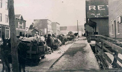
-
Article
Atikokan
Atikokan, Ont, incorporated as a township in 1954, population 2787 (2011c), 3293 (2006c). The Township of Atikokan is located in northwestern Ontario on the Atikokan River, 220 km west of Thunder Bay.
"https://thecanadianencyclopedia.ca/images/tce_placeholder.jpg?v=e9dca980c9bdb3aa11e832e7ea94f5d9" // resources/views/front/categories/view.blade.php
https://thecanadianencyclopedia.ca/images/tce_placeholder.jpg?v=e9dca980c9bdb3aa11e832e7ea94f5d9
-
Article
Atlin
Atlin, BC, Unincorporated Place, elevation 671 m. Atlin is a small community of about 400 residents situated on Atlin Lake in the lake district of the northwest corner of the province, 182 kilometres southeast of Whitehorse, Yukon.
"https://thecanadianencyclopedia.ca/images/tce_placeholder.jpg?v=e9dca980c9bdb3aa11e832e7ea94f5d9" // resources/views/front/categories/view.blade.php
https://thecanadianencyclopedia.ca/images/tce_placeholder.jpg?v=e9dca980c9bdb3aa11e832e7ea94f5d9