Share on Facebook
 Share on X
 Share by Email
 Share on Google Classroom
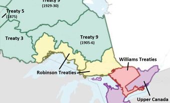
The Lake Simcoe Treaty, or Treaty No. 16, of 1815 was signed between the British authorities in Upper Canada (later Ontario) and the Anishinaabe peoples. It concerned the purchase of about 100,000 hectares of land between Lake Simcoe and Lake Huron. Its purpose was to acquire territory to the north and south of that covered under the John Collins’ Purchase of 1785 and south of that acquired by Penetanguishene Treaty, Treaty No. 5, of 1798. This gave the British control of all the land between Lake Simcoe and Georgian Bay. The Lake Simcoe Treaty is one of many agreements made during the late 18th and early 19th centuries known as the Upper Canada Land Surrenders.

Historical Context
The John Collins’ Purchase of 1785 covered the use of lands between the northwestern end of Lake Simcoe to an inlet off Georgian Bay in Lake Huron known as Matchedash Bay. Although little evidence remains of the original negotiations, Collins reported that he had obtained agreement from Indigenous peoples in the area to allow the Crown to make roads through their territory to connect Lake Simcoe and Lake Huron. No roads were built, however, and the purchase resulted in a negotiated right of way passage through it.
Collins also noted that no payment had been made to achieve this agreement, nor had one been demanded. He stated that the chiefs in question said their people were poor and needed clothing but would let “their good Father” (King George III) determine the quantity. The lack of documentary evidence for the boundaries of the John Collins’ Purchase caused confusion, however, and resulted in further negotiations until the boundaries were finally resolved much later. In the interim, the British continued to use the land covered by the original verbal agreement.
After the American Revolutionary War ended in 1783, Upper Canadians needed a direct route to the upper Great Lakes to avoid having to travel through the United States (see also Canada and the American Revolution; Upper Canada). In 1793, Lieutenant-Governor John Graves Simcoe chose Penetanguishene Bay as a deep-water harbour to bypass American-controlled waters and the location to build a naval base on Lake Huron before the United States could build one. The Penetanguishene Treaty, or Treaty No. 5, of 1798 encompasses lands on the peninsulas to the east and northwest of present-day Penetanguishene on Georgian Bay so the base could be built and its approaches protected.
Between 1808 and 1811, government surveyor Samuel Wilmot explored and mapped the route between Lake Simcoe and Penetanguishene. At the same time, relations between the new United States and the British were not good and culminated in the War of 1812. At the end of the war in 1814, the British began to build a rough military road that fall through the wilderness from Kempenfelt Bay on Lake Simcoe to Penetanguishene Bay on Lake Huron, even though the territory did not yet belong to them.
Description
The Lake Simcoe Treaty consists of two separate documents, known as indentures. Both were signed at Kempenfelt Bay by representatives of the Anishinaabe and British authorities. Three principal chiefs, Kinaybicoinini, Aisaince and Misquuckkey signed for the Anishinaabeg (see also William Yellowhead). The British signatories were provincial commissioners Elisha Belman and Henry Proctor, Capt. W.M. Cochrane representing the army, Lieut. Alex Ferguson of the Indian Department, interpreter William Gruet and J. Givens representing the Crown.
The first indenture was signed on 17 November 1815, and the second was signed the next day. The first document gave five shillings to each of the three chiefs, plus an annual rent of one peppercorn, which meant a token or nominal amount. The second indenture provided a one-time payment of £4,000.
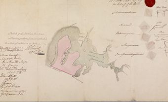
The treaty covered two separate parcels of land, a larger one to the south of the John Collins’ Purchase of 1785 and a much smaller one to the north of it. Along with the land included in the earlier Collins’ Purchase and the Penetanguishene Treaty, Upper Canada now included a large circular tract of territory between Lake Simcoe and Lake Huron.
Recognition
On 30 May 1932, the Historic Sites and Monuments Board of Canada unveiled a plaque in Couchiching Beach Park in Orillia, Ontario, titled “Surrender of Indian Lands.” It refers to the treaties of 1798, 1815 and 1818, which ceded the lands lying north and west of Lake Simcoe. It was from this area that grants were made to military veterans and the children of Loyalists “in fulfillment of earlier pledges.” The wording of the plaque has been identified for review, which can be for a number of reasons, one of which is “outdated language or terminology.”
Did you know?
Today, Ontario Highway 93 and Simcoe County Road 93, which run from Barrie to Penetanguishene, closely follow the route of the original Penetanguishene Road and are still known by that name.